Our friends have asked frequently, “What’s been your best holiday?” and now Yellow Zebra Safari is asking the same question. For a chance to win a Tanzanian Safari, they are asking entrants to write a travelblog about their best trip ever and submit it by October 31st.
My best trip ever has to be the one we are currently on. Roughly two years ago, out of the clear blue, one evening my wife floated the idea that she was thinking of retiring soon. I had been downsized several years earlier and had found a second career as a USPS mailman, delivering junk mail and mountains of Amazon packages through terrible weather, while deftly avoiding ferocious Pomeranians. The idea struck home. Okay! But, what would we do?
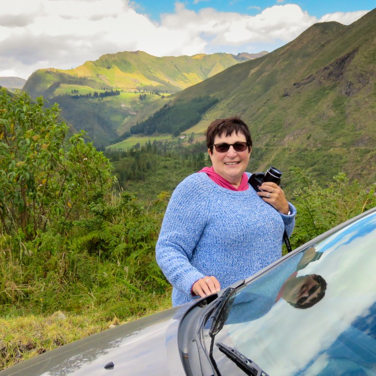
As a pair of seasoned citizens, we are not the typical demographic for a gap year/round the world trip, though our community is growing. We sold most of our belongings, put the rest into storage and hit the road. I write this from Olon, Ecuador, where we are practicing slow travel, a two-year journey around the world with the best travel partner, my wife.We’ve been on the road for more than 100 days now; previously, our longest trip was just shy of three weeks, with carry-on luggage only. So, we felt fully prepared to tackle this challenge (insert wink here.) Needless to say, there is a learning curve, but we have the right mind set. In late October, we move north to Guatemala, followed by a cruise to Cuba. The first part of 2019 will see us in Europe, and after that, who knows? We’ve discussed heading to South Africa, then working our way north and through East Africa, trying to have as many big game safari experiences as possible. This has been a dream of mine since I unwrapped my first National Geographic magazine and was enthralled by the spectacular images of the great migration across the Serengeti. Winning this Tanzanian Safari experience by Yellow Zebra Safari would make this dream a reality.
Our earlier adventures have prepped us for mishaps. At a filling station in France, I put gasoline into the rental car’s diesel engine; in Italy, we were trapped in a parking area when our token would not raise the automatic exit gate; we have experienced canceled flights and missed connections which resulted in airport overnights on hard floors. Trips to Peru, Mexico, Guatemala, Fiji, Turkey and Morocco have broadened our perspective; we view the world as global citizens, and take seriously our responsibilities as travelers and stewards of the planet.
“Travel is fatal to prejudice, bigotry, and narrow-mindedness, and many of our people need it sorely on these accounts. Broad, wholesome, charitable views of men and things cannot be acquired by vegetating in one little corner of the earth all one’s lifetime.”
The first sentence of this quote from Mark Twain is the one most widely known. We think the second line is more relevant today, since we really do share commonality with people the world over.
We are currently in the midst of our best holiday ever, a life changing/lifestyle change that will create lasting memories.
Time has passed so quickly, with our days full of adventure and exploring, and it is difficult to believe we’ve been away from home for one hundred days already. The month of July was spent driving down the East Coast of the US, visiting friends and family and having a great time. Our first three weeks in Ecuador were packed with activity. Quito, the Galapagos Islands and driving south to Cuenca along the Pan-American Highway, also known as the Avenue of the Volcanoes, filled our itinerary.
Arriving in Cuenca, we set up home for five weeks in a lovely studio apartment, for under $500 per month, that had a large rooftop deck with tremendous views over the Rio Tomebamba. We immersed ourselves in the neighborhood; it was a delight to shop in the city’s central market for exotic fruits, (pitacaya is our favorite,) from the Amazon region, plentiful and pricey, or for locally grown vegetables which were so inexpensive. Every city block seemed to have multiple panaderias, bakeries, that offered extremely inexpensive and delicous baked goods. A dozen roses usually cost four dollars. Alternately, a large, American style supermarket had prices that rivaled those around our old home in Pennsylvania. Cuenca was full of the ubiquitous yellow taxis. For under two dollars we could travel to the far reaches of this sprawling city.
Adapting to our surroundings in a new country, we noticed that the sun sets quickly here with practically no twilight period. We are also adjusting to the concept of long-term travel and retirement itself – what our expectations should be on a daily basis. 24/7 together is a new concept for a previously working couple. We have often asked each other which day of the week it is. Every day does not need to be nor can it be an adventure. We enjoyed chilling on the rooftop, reading and writing. Alternately, we wandered through different parts of the city taking advantage of the many free public museums scattered about.
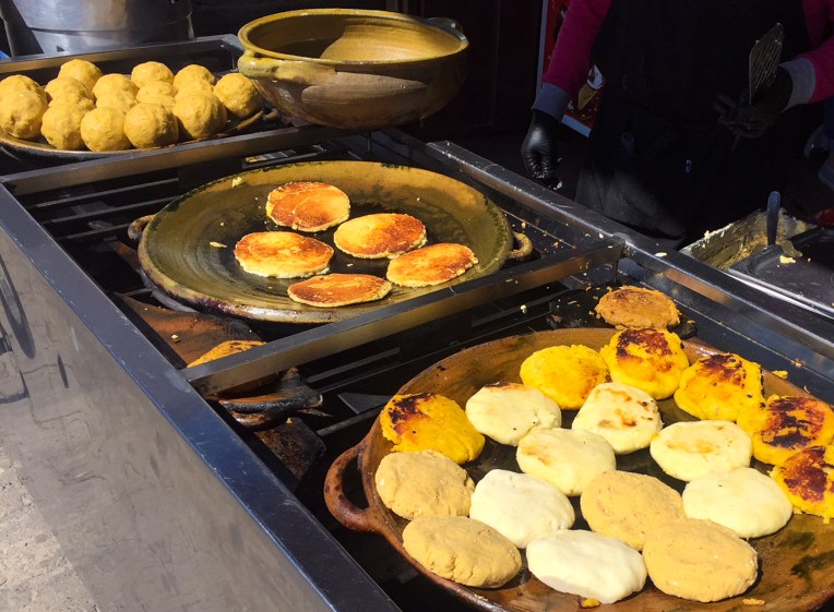
The dining out options in Cuenca covered the full spectrum from mom and pop holes-in-the-wall offering the plate of the day, plata del dia, where for $3.50 you received a very good three course lunch, to fine gourmet dining that reasonably ran about $50.00 for two with wine, dessert and coffee in a beautiful restaurant.One of our favorite snacks was Tortilla de Choclo, eighty cents, a corn pancake that was grilled on a large ceramic plate, curbside, as you waited. Often, coffee and dessert cost more than lunch itself.
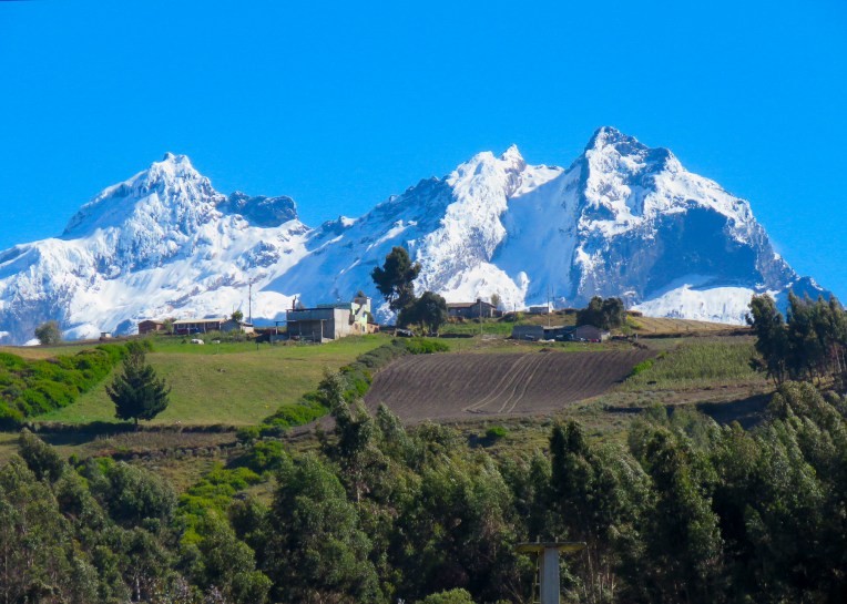
There were some difficulties with our new environment. Mainly we had trouble acclimating to Cuenca’s 8,500ft altitude. This was surprising because we spent the better part of two weeks driving through the Andes Mountain Range at heights exceeding 10,000ft and surely thought Cuenca’s setting would be easier on us. Donna required a visit to the emergency room of a local private hospital one Sunday morning after feeling dizzy for too long. After checking that her vitals were okay the doctor wrote a prescription for Dramamine to treat the effects of altitude sickness. A week’s supply of the drug cost $2.40. Our forty-five minutes in the emergency room cost thirty-two dollars.
A long weekend, a vacation from our vacation, took us to Vilcabamba, a small town in Ecuador’s southern Andes. A reputation as “the valley of longevity,” with mineral rich mountain water and crisp air, has attracted a diverse international expat population of aging hippies. It was ten degrees warmer there, which was a nice reprieve from the chilly days and nights in Cuenca. At Hosteria Izhcayluma, a wonderful and very affordable eco-lodge/spa, we indulged in deep tissue massages that lasted for ninety minutes and cost all of $24.00 each. Feeling adventurous I chose to go on what I thought would be a leisurely five-hour horseback ride through the surrounding mountains. The brochure advertised “gallop with our horses.” Thinking this was hyperbole I signed on. From the moment we all mounted our horses we galloped out of the stables, through Vilcabamba, into the mountains and back. I walked liked a saddle-sore cowboy for a week after that.One of the reasons we chose Cuenca for our first short term rental was so that I could take advantage of their dental tourism offerings. I had put off getting things done in the states because of what I thought were excessive cost, even with insurance. I am extremely pleased with the dental care that I received at Finding Health in Ecuador. Tooth extraction – $35.00, cavity – $25.00, two-tooth bridge – $250.00. Our premise that we could live abroad more economically than living back in the states is so far holding true.Currently we are in Olon, a rustic beach town on Ecuador’s southern Pacific coast with a wide, flat sandy beach that stretches for nearly five miles without a high-rise to been seen. It’s off season, mostly cloudy, but the water is still warm, perfect conditions for the handful of surfers and us. Fishermen still launch skiffs through the surf from the beach, and fathers can be seen taking their kids to school on the handlebars of their motorcycles, gently splashing through the incoming tide. Our rent for the month of October is $730.00 with breakfast included!
By ten o’clock each evening the streets are empty. From our apartment at night we can hear the waves crashing onto the beach, along with roosters crowing – they start at one in the morning, seemingly on a campaign to discourage tourism – and dogs barking to each other. There is no traffic in this tiny four block square village. Everyone walks in the middle of the road, roosters, dogs and cats included. Every day pushcart vendors wheel their offerings of fruit, eggs, cheese, clothing, kitchen supplies, etc. through town, each peddler singing out a different sales pitch.
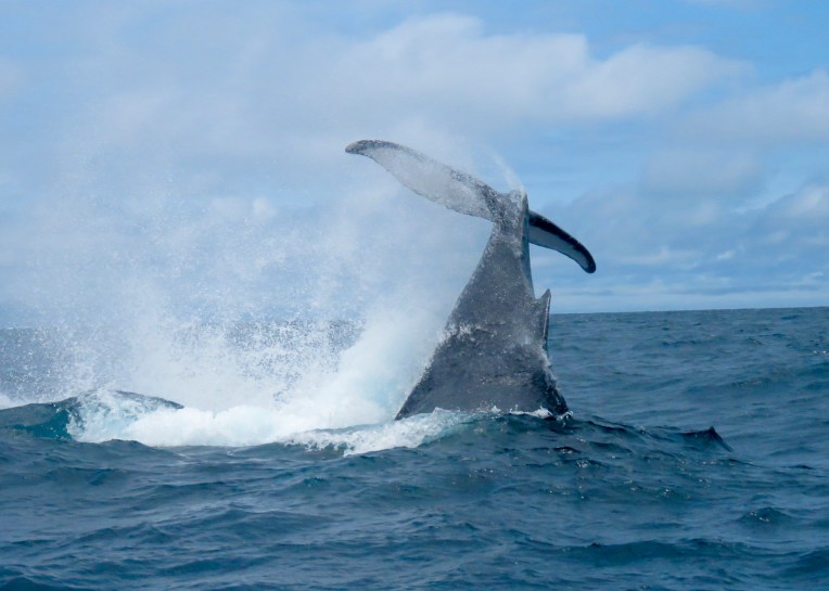
For a change of scenery, we took a day cruise out of Puerto Lopez to Isla de la Plata, an uninhabited island which is part of Machalilla National Park. It is also referred to as the “budget Galapagos.” Fifty dollars per person included shuttle transportation, boat ride, snorkeling gear, lunch, a three-hour hike with a licensed guide to view nesting birds and most importantly the chance to see humpback whales.
At the outdoor fish market, two kilos of fresh large shrimp set us back six dollars. Several doors down at a little house with the barbeque out front, two plates of fresh grilled fish with a beer cost five dollars for dinner. For a tiny place, this village has a surprising number of eateries, most of them created by northern European surfers who fell in love with the waves here and never left. Cotinga’s might be the only restaurant in Ecuador where you can get home-made borscht, prepared by Olga a Russian expat.
The only thing Olon really needs is a French inspired chef whose specialty is Coq au Vin. Roosters, you’ve been warned!
The road conditions don’t warrant driving after dark, there are just to many ifs, so we departed early from Hostal Taita Cristobal, after wishing our table mates safe travels and adventures as they hoisted heavy backpacks to their shoulders. The Quilotoa Crater and Baños, the adventure capital of Ecuador, were our day’s destinations. Really, Donna’s not going to go zip lining nor am I willing to try bungie jumping. Still, we thought we could find an adventurous activity where one foot was required to be in contact with the ground occasionally. Experience has taught us to double the amount of time our GPS app suggests it will take to get from point A to B due to road conditions and the frequent stops for photo opps. As my wife says “if we continue to stop every 100 yard for pictures, we’ll never get there.” The return drive back to the main road in Sigchos seemed to go very quickly. We only stopped for photos around every other bend. Fortunately we were able to drive down the center of the road or hug the left side to avoid looking over the precipice most of the time. It was nerve racking when we had to get closer to the edge to make room for an oncoming truck to pass. We never thought the sight of a guardrail would bring as much joy as it did when we got back on the main road in Sigchos. As our host had promised the road out of Sigchos was freshly paved. Along with a bright, yellow double line down the center it had shiny, heavenly guardrails around every curve! Even with the new road there were still hazards. There were numerous signs for falling rock or mudslide zones. We also shared it with folks herding sheep or cattle, donkeys carrying water barrels and folks selling things from motorcycles towing small trailers. Suddenly around one curve, marked by only 2 piles of dirt as a warning, about one hundred feet of road had collapsed into a steep ravine. There were no flagmen, orange cones or repair crews in the vicinity. The hair on the back of our necks stood up.
The treed landscape slowly disappeared and was replaced with barren windswept vistas as we rose in altitude, the closer we got to Quilotoa. Gale force winds ripped around us on the ridge above the magnificant Quilotoa Crater (12,913ft), its turquoise waters calm a thousand feet below. Local legend believes Quilotoa fell in love with the Cotopaxi volcano, and the tears from her unrequited love filled the crater. Teary-eyed from the wind chill and altitude, we sought out some restorative coca tea.
A few miles down the road Canyon del Rio Toachi, a mini Grand Canyon, offered interesting photo opportunities from the parking area. Further on small groups of men and women could be seen in the fields winnowing grain by throwing it into the air to separate the wheat from the chaff. Barns made from thatch lined the road for storage.In Zumbahua, with the hills green again, we picked up route E30, which connects the Pacific Coast region with the Amazon basin through Baños. It is a slow cross country route that encounters numerous traffic lights as it passes through many towns along the way, but gives wonderful insight into how folks live along this corridor of commerce. Shops of every variety lined both sides of the road with their doors and workshops literally on curb of the road.
Baños is a well developed town of about 40 blocks that is know for its location under the towering, 16,575ft high and still active Volcan Tungurahua. As recently as two years ago, the town had to be evacuated due to an eruption. Mineral rich hot-springs, numerous waterfalls and the close proximity to the Amazon basin made this a must stop for two days.
The sight of a tall waterfall pouring down from a ridge above town greeted us a we turned down the street for Hostal Posada de Arte. This small boutique hotel was as whimsical as its name suggests, with a colorful interior and excellent, locally created art decorating the walls. If the wind blew just right, mist from the waterfall fell on the inn. Breakfast and dinner at the hotel were delightful with a large fireplace warming the room.
On the central plaza several blocks away stood the Church of our Lady of Holy Water which has many large paintings depicting miracles granted by the Virgin Mary. Most illustrate some mishaps centuries ago with the turbulent Rio Pastaza which rushes through town.
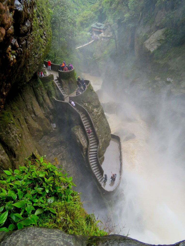
Clouds hung below the mountain peaks as we hiked down to the El Pailon del Diablo, the Devil’s Waterfall. This met our criteria for keeping our feet on the ground. It was an amazing descent along a cloud forest trail to a thundering waterfall. We weren’t planning on getting wet here, drenched is more like it; there is no way to avoid it, especially if you squirrel under the ledge to find the rabbit hole that leads to the highest viewing platform as we did! And you haven’t experienced the fury of this cascade fully unless you do. There is a rest hut at the bottom of the trail, by the suspension bridge, with a fireplace where we relaxed and purchased some refreshments to energize ourselves before the trek back up.
The hike back to the parking area wasn’t as difficult as we had worried, nevertheless our muscles ached. So being in the land of holistic cures we tried a locally brewed craft beer by (no kidding) Shaman breweries. It was so delicous, one of the best brews ever. Sadly, we haven’t been able to find it since.
The Swing at the End of the World was another matter. Hanging from a treehouse situated on the edge of a ravine, with Volcan Tungurahua rising dramatically to the sky across the way, you can get a thrilling swing or a swing with a twist as many times as you dare. Cost of entry for the day – $1.00. Brave soul, Donna got airborne!
We took the first left out of Baños onto Rt. 490, the slow road, heading south to Riobamba. Fortunately, the weather was with us as we began to climb out of the valley, rewarding us with tremendous views of Baños in the valley below and Volcan Tungurahua to the east. The route passed through many small villages and verdant farmland as it sinuously followed the Rio Pastaza which snaked through the valley several hundred feet below us. With such steep terrain we were always amazed that every acre seemed to be cultivated by manual labor. Constantly battling the whims of nature, a hard living is extracted from the earth here. Mother nature rules in these mountains, as witnessed by the path of older, washed away bridges we viewed.
The majestic Volcan Chimborazo came into view for the first time as we crested a small hill on the outskirts of Riobamba. At 20,549ft it is the tallest mountain in Ecuador and the highest near the equator. As the crow flies the mountain was only 15 miles away, but as the road curved it took us another two and a half hours to get to our night’s lodging at Hosteria La Andaluza in San Andres, which was very near the mountain on Rt. 35, the Pan-American Highway. The mountain was hidden by afternoon clouds by the time we pulled into the hacienda’s driveway.
Seeing two exhausted travelers approaching, the staff came from behind the reception desk to take our bags and welcome us. A woodstove in the corner warmed pots of their high altitude tea remedy Canelazo, a mixture of local herbs and fruit which also could be consumed with an optional splash of a sugarcane moonshine. It definitely warmed our bones. Red rose petals on the bed sheets greeted us as we opened the door to our guestroom. The functioning radiator was a nice surprise. This was the first hotel in Ecuador that we stayed in that offered heat; normally it’s window open, window closed, blankets on or off or light the fireplace. Our room overlooked a fountain filled with rose petals and freshly ploughed fields in the distance.
The hacienda dates from 1555 and echoes with history, “Simon Bolivar slept here,” had a familiar ring to it. Ornate, antique furnishings highlighting the craftsmanship of an earlier era filled the common areas. As we wandered about the grounds we were delighted to discover one courtyard had a family of domestic rabbits scurrying about it. A large basket of carrots was left off to the side, so guests could feed them. Two peacocks also strutted about fanning their elegant feathers. That evening chandeliers and candlelit tables created a romantic setting as the filet mignon we ordered was threactically flambéed at our table.
The majestic Volcan Chimborazo.
Chimborazo gleamed brilliantly in the morning sun and filled the horizon across the road from the inn. It seemed almost close enough to touch, but it was only an illusion. To the north just a tiny wedge of Volcan Carihuairazo appeared in the distance. We spent a good part of the day driving through the surrounding farmlands trying to get as close as we could to these beautiful peaks.
Volcan Carihuairazo
On mountain overload, later that afternoon we headed into the historic heart of Riobamba just to get a feel for the city and a change of pace. We had a difficult time figuring out the on-street parking rules, but fortunately after circling several blocks we spotted a parking attendant who issued us a ticket to park for fifty cents. Parque Maldonado centers the historic district with a monument dedicated to Pedro Vicente Maldonado, a multi-disciplined Ecuadorian scientist known for his work with the French Geodesic Mission. He also had responsibilities as Mayor of the City, Lieutenant Magistrate Governor of the Emerald Province, Horseman of the Golden Key and Gentleman of the Camera. Obviously a renaissance man; we weren’t sure if the statue was tall enough. Bordering the plaza, La Catedral de San Pedro’s baroque façade is all that remains of the original structure, one of Riobamba’s earliest, after a 1797 earthquake estimated at a 8.3 magnitude shook the region for three minutes and left thousands dead.
A short walk away, Mercado de San Alfonso filled a city block with terraced displays of flowers and exotic fruits (oh, the creative possibilities – truly a smoothie lover’s paradise), seldom seen in North American markets. Numerous varieties of potatoes in every color and size filled sacks aligned neatly down the aisles.
The next morning we left the wonderful hospitality of Hosteria La Andaluza for Cuenca, our final destination and home for the next five weeks. Fields of quinoa hugged the steep slopes as we continued south on Rt. E35. In one small village we passed parade floats and camionetas, shared pick-up truck taxis, filled with costumed revelers leaving town after what looked like a lively celebration. If we had only arrived a little sooner. These are the unexpected things you happen across when you travel the backroads. Places and events that are too small to be included in the popular tour guides, but entertaining, interesting and eye-opening nevertheless.
As we left the highway in Sangolqui, grilled Cuy, (guinea pig, the national dish) impaled on tall sticks lined both sides of the road, to entice us to stop for a taste. We drove on, unable to consume a pet animal yet. Not sure what side of the omen scale this greeting fell on. We continued for several hours, driving along the route we had chosen through green farmland, before entering the higher regions that encompass Cotopaxi National Park. The relatively smooth cobbled road soon transitioned to dirt as it began to follow a narrow ridgeline that wove between small villages. The views of the lush valleys on both sides of the road were fantastic; just finding the appropriate place to stop hindered us from taking as many pictures as we wanted to. Occasionally we were passed by a speeding tanker truck hurrying from dairy farm to dairy farm to collect the day’s fresh milk.
Slowly the terrain changed and slopes of eucalyptus trees towered over the road. Our route brought us through the eastern side of Refugio de Vida Silvestre Pasochoa, a wildlife and habitat preserve of 33,000 acres. Signs for waterfalls began to appear, tempting us to stop at the Rumipamba Falls trailhead to stretch our legs. We followed the trail until a small suspension footbridge and a glance at the time turned us back.
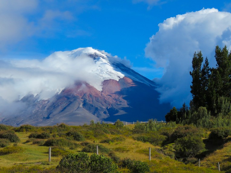
Forest turned to shrubland as we rose in elevation and neared Cotopaxi National Park. Having not seen a car or truck for awhile now, we were surprised when all of a sudden five vehicles were parked, a little ways from each other, in the middle of nowhere. Not a person in sight. Was this a local lovers lane? Further along more cars. Thursday afternoon, what an amorous society we thought – “obtener una habitacion” – get a room!, seems to have lost something in translation. Later we spotted folks carrying baskets full of small blue berries, Mortiños or Andean Blueberries as it turned out, which are highly sought after. Around a bend the cloud covered dome of Cotopaxi (19,347ft) appeared for the first time.
Surprised by our appearance, a “how did you arrive here?” greeted us as we checked in. A large cloud of dust behind an SUV, driven by a professional driver, usually announces guests about to check in, we were told. Our humble vehicle was lost behind tall blueberry bushes in the parking area. Being surrounded by thousands of acres Andean Blueberry bushes, Hacienda Los Mortiños, is appropriately named. Located just outside the northern entrance to Cotopaxi National Park, (which encompasses 82,500 acres and three other volcanoes , Ruminahui, Sincholaqua and Morurco within its boundary) it offers inspiring views of the surrounding landscape from every window. If you aren’t into mountain biking, horseback riding or hiking, just sitting next to the fireplace in the restaurant, watching the weather change with clouds building then dissipating suddenly to reveal the shy summit of Cotopaxi is a mesmerizing and relaxing way to spend any day.
Towards sunset, wild llamas grazed near the main building. We snapped away while the dominant male approached closer than the rest, as if to announce that he was the protector of his harem. It was a postcard perfect moment with Cotopaxi as the backdrop. The temperature drops quickly at these altitudes once the sun is low in the sky. Towards sunset a housekeeper lite the woodstove in our room to keep the night chill away.
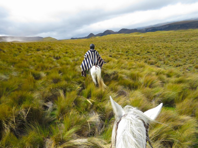
It was not as easy getting onto a horse as it was a few years ago, but I decided to go for a three hour ride with Jorge, a guide from Los Mortiños. Pull back on the reigns and say “Soa,” sounds like whoa, when you want to stop were my instructions in Spanish. I am not a very seasoned rider, but I’ve gotten my limited experience on steep trails in the Rocky Mountains of Montana and know enough to realize that the horse is smarter than me in keeping us both safe in difficult terrain. The horse leads, “you’re just baggage” a wrangler once told me. In a stiff cold wind we saddled up, “Vamamos amigo” and we were off. Just outside the reserve, cattle grazed in the wind swept grassland and llamas could be seen in the distance.
As we entered the park and rode along a deep gully I got my first chance to yell “Soa,” at least I hope I was yelling the right phrase, when a unseen bull violently exploded from the earth and spooked our horses into a sudden gallop! That was more than enough excitement for me. We were miles away from the base of Cotopaxi, but the high plains landscape had a raw natural beauty to it. Each turn of the trail and every hill crested brought wonderful vistas. The only sound was the constant wind. Later we would flush Andean quail and ride through several herds of wild horses. The ride was exhilarating!
I’m not sure which road was bumpier, the one leading to Hacienda Los Mortiños or the one heading away, but we were relieved to be back on the Pan American highway for awhile, as we headed to three days of very inexpensive R&R at a hostel in Isinlivi on the Quilotoa Loop. Not sure what to expect at the hostel, (we are not exactly the demographic you would find there,) we decided to fortify ourselves with lunch at the historic Hacienda La Cienega which dates from 1695. As we pulled into the stately drive that led to the hacienda we wondered if there would be sticker shock when we saw the lunch menu. The elegant dining room overlooked a beautifully landscaped courtyard and bubbling fountain, where an extended family was posing for a group photo. Simultaneously, a rock band was filming a music video on the steps of the hacienda’s ancient, private chapel. Surprisingly there were many reasonably priced entrees offered for lunch. Hacienda La Cienega is just a short detour off the highway in Tanicuchi, but well worth it. It’s a great destination to experience the grandeur of a forgotten way of life.
The Quilotoa Loop is primarily known as a mountainous hiking trail that links remote, isolated villages where indigenous Kichwa is the native language, via a series of footpaths that have been followed for several thousand years.
The elevations of the villages range from 9200ft at Isinlivi to 12,500ft at the Quilotoa Crater. Fortunately Hostal Taita Cristobal, our base for three days, was the in the village of Isinlivi. Why here? We had been moving almost continuously since returning from our Galapagos trip, so it was time to recharge our batteries and just chill for a couple of days. Also we wanted to experience something more remote and less expensive. So for under $40.00 per night Hostal Taita Cristobal provided a beautiful setting, a nice private room with en-suite bath with hot water along with two hearty and delicous meals per day. Plus they had llamas on the property!
Getting there was there harrowing part. Outside of Tanicuchi the road turned to dirt and the low hills became worthy of the Alps with footpaths and stairs cut into steep slopes leading to places unseen. We glimpsed the twin peaks of Mt. Iliniza Sur (17,300ft) and Iliniza Norte (16,900ft). The GPS showed a sinuous route that wound on and on forever. We quickly developed a system to navigate the numerous blind S curves we were encountering. I would lean on the horn for 3 long blasts as we were entered a curve and Donna would try to see as far around the corner as possible and give a thumbs if all was clear as we inched uphill in second or first gear. Once you are off the highway guardrails are non-existent!!! Several times the hair was raised on the back of our necks and Donna grabbed the “Oh Jesus!” strap above the passenger door. We often faced buses barreling downhill at us in a cloud of dust and we tried to navigate the switch-back turns, clinging as tightly to the corner as possible. We passed many sobering roadside memorials to those less lucky. Many miles were traveled in second gear with a top speed of twenty miles an hour or so. Every now and then we would stop and check the road when we heard a loud metallic ping come from the undercarriage, fearing that we lost part of the car. Fortunately our wheels stayed intact. Occasionally we drove through clouds of smoke, billowing up from fields farmers had set afire to burn off the stubble left from the harvest. We saw one partially hidden directional sign for our inn, which contradicted all three GPS mapping apps we were using. Despite no mention of miles to go, trustingly we followed it. At times we were driving above the clouds.
For the next three days and nights we shared wonderful meals around a communal table with hikers from the United Kingdom, Belgium, France and Siberia. Stories told, plans and information shared, we learned about maps.me, which turned out to be quite helpful later on, and as citizens of the world how much we share in common. After midnight the wind blew so fiercely, for several hours, we thought the roof might fly off. Over the several days spent there, we turned out to be the only guests crazy enough to drive ourselves into this remote region. At tea time every afternoon the owner brought the llamas, 2 adults and a three month old, home from grazing and staked them out behind the inn for the night, to the delight of the guests. Just watching the little one playfully scamper around the yard was worth the effort to get there. We strolled around Isinlivi that Sunday just as church was letting out and villagers from outlying hamlets were sitting down on the curb to catch up on local news. Around the corner sheep grazed in the school yard, and a large hog was reluctantly led uphill through town by a woman and her daughter. Weary backpackers, dusty from the trail, inquired about lodging.
Discussing our driving plans over a map with one of the tour guides one morning, the inn keeper interjected that you can’t go that way, “YOU REALLY DO NEED A FOUR WHEEL DRIVE” for that route. “You must return the way you came, the road gets better as you leave Sigchos, it was just redone.”
I never thought I would be so happy to see a guardrail!
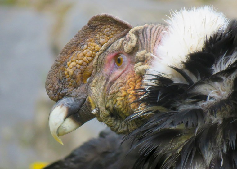
On the way to Parque Condor, a rescue center for Andean birds of prey, our GPS failed us and lead us down a dirt track on the other side of the mountain that we were supposed to be at the top of. Fortunately the first person we asked walking along the road spoke a little English and pointed us back in the direction from which we came. Before we turned around she looked seriously at our car, shook her head and said “I don’t think your little car can make it there”. We too had our doubts when we saw the condition of the dirt road and the incline that faced us. “It’s not what you drive, but how you drive it” became my favorite mantra when considering the capabilities of our wheels. And yes, we wished we had a little more ground clearance occasionally, and more horsepower. With minutes to spare we made it in time for the morning “free flight” demonstration at 11:30.
In a stone amphitheater set into the side of the mountain top, high above the valley below, a falconer performed with a variety of Andean hawks, to the audience’s delight. Starting with their smallest raptor and working their way to the larger ones, from behind us his assistants would release the birds from their cages and they would fly through the crowd to land on the sheathed hand of the falconer. As the falconer tossed food in the air, the birds would grab it in mid-flight, circle around and land on perches amidst the audience. Evidently the falconer moonlighted as a stand up comedian as the enthralled audience erupted in laughter numerous times throughout the hour and a half show. Unfortunately, “no hablo Espanol,” the jokes were lost on us. The park also houses a great variety of owls and condors which were a delight to photograph.
We were so anticipating the Otavalo Market, and better yet we were there on a Saturday, its largest day. As promised, the streets were full of vendor stalls radiating for blocks from the Artisan Square. Unfortunately, many stalls featured everyday essentials for the local populace and not the high quality crafts that the market had previously built its legendary status on. At the very center on the Artisans square, what looked liked machine woven textiles, made in Ecuador, were available and priced accordingly.
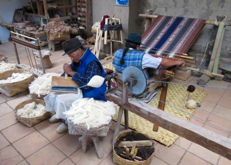
We opted to visit one of the local weavers, Miguel Andrango, at his home workshop in Agato to view his unique and one of a kind textiles, all woven by hand on a backstrap loom. A fourth generation weaver, he explained to us how everything was done by hand. From the shearing, cleaning, carding, spinning and then dying the wool using local plants or insects to create the colors needed. A hand woven blanket wide enough for a double bed takes two months to weave by hand. It is so important to support these local artisans as they are knowledge keepers of their craft and maybe the last, as the younger generation shows little interest in keeping these traditional crafts alive. Please try to avoid buying cheap foreign knock-offs at these markets. The local craftspeople suffer terribly from this competition.
The town of San Antonio de Ibarra has two large plazas, one block apart, which are lined with numerous traditional woodcarvers shops. Here we found artisans creating religious statuary for homes and churches and more contemporary pieces for decoration, in workshops fragrant with cedar and sawdust.
We were still weaving with our sea legs as we stood at the Budget Rental Car counter in dismay and frustration. We were told that our reservation (that we had had for six months) was canceled an hour earlier. Seems we were late for our pickup, and since Budget didn’t hear from us, they cancelled our car. And since we were on an airplane, it wasn’t possible to call. We quickly found the LAST vehicle available at the airport at the Thrifty Car rental counter, as more than twice the price. The best they could do was a SUV with the driver’s door severely banged in, but it was a set of wheels and as they say “vamanos amigos!”
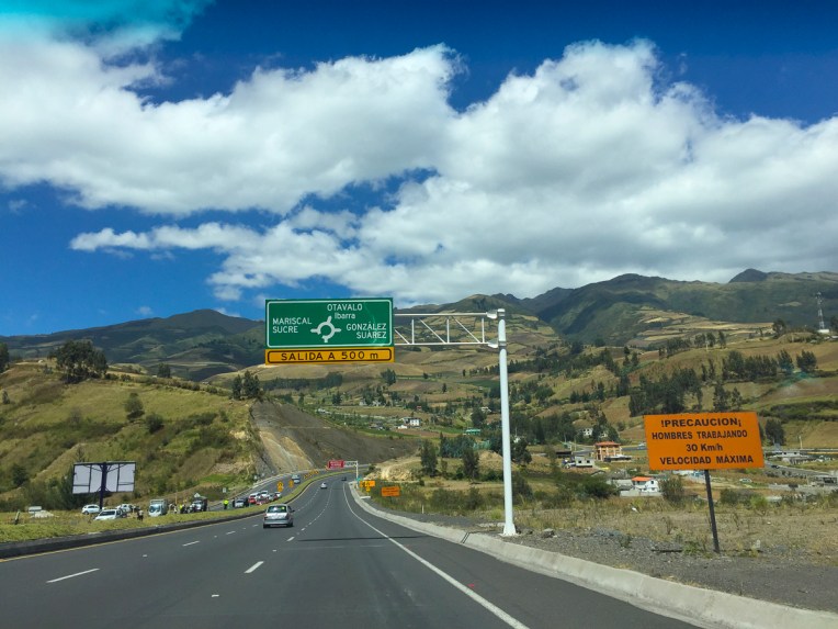
Ecuador has invested heavily in infrastructure projects and the Pan American highway is a marvel of engineering, whisking drivers away from the Quito area through numerous S curves that steeply climb then descend, then repeat, repeat, and repeat until you’ve reached Otavalo. Sometimes the highway is eight lanes wide and at other times it’s only two. If you love S curves, the Pan American highway is a definite must drive.
Though an international highway, many times the road is the main street through small towns with active businesses lining its sides. This area is full of nurseries growing flowers, mostly roses, for international export. Numerous street vendors also lined the route selling a dozen roses for three dollars. In Otavalo we had to exchange our muscular SUV for a small 5-speed, manual transmission, sedan.
Due to the steep, long climbs and S curves of the highway we spent many miles in second gear. This continued on the secondary roads as well – they started off asphalt, then switched to flat pavers, followed by cobblestone paving (with a center stone line) which eventually turned into compacted dirt with ruts. Did I say RUTS?! First and second gears ruled now as it seemed there was not a level or straight road in all of Ecuador, especially where were we were headed. I had to treat Donna to massage therapy after one particularly bone-jarring adventure, where we were lucky that the muffler didn’t get snagged on a rock . And of course there is the thrill factor, with side roads in the mountains not having guardrails and buses barreling down hill at you in a cloud of dust as you are trying to negotiate an uphill 180 degree switchback in first gear on a dirt road wide enough for one car! Numerous roadside crosses dotted the landscape for an instant reality check. Really these roads would be a challenge for the drivers that do the infamous Baja off-road race! Why buy a ticket for a rollercoaster when you can scare yourself to death driving the secondary roads of Ecuador. As I said before, the Pan American highway is a great road in perfect condition without potholes. Once you leave it be warned. And really do opt for that SUV. Vroom, vroom!
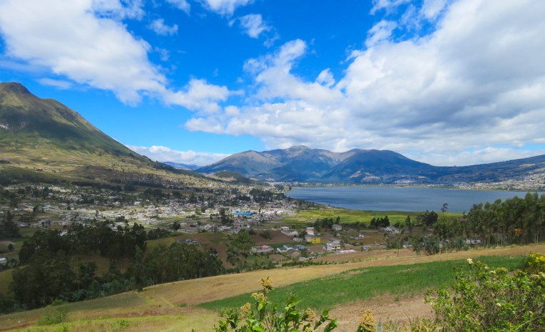
Set at 9800ft altitude, high in the hills above Otavalo, Casa Mojanda is definitely a destination; a boutique lodge that practices sustainability. The massive dining room has 3 foot thick walls constructed using a rammed earth technique which was then whitewashed. Rustic cabins with kiva fireplaces, to ease away the chill of an Andean night, are set into the hillside to follow the natural contour of the terrain and take full advantage of the view. Lower on the property, a massive organic garden supplies the kitchen. And an authentic sweat lodge is available for those would want to hire a local, registered shaman and indulge in the indigenous traditions. For a side trip we drove up to the crater lake of Lagunas de Mojanda which is at 12,000ft, and got the feel for the first of many to follow ubiquitous cobbled roads. So far our transportation has proven to be the little car that could.
On the way to Parque Condor, a rescue center for Andean birds of prey, our GPS failed us and lead us down a dirt track on the other side of the mountain that we were supposed to be at the top of. Fortunately the first person we asked walking along the road spoke a little English and pointed us back in the direction from which we came. Before we turned around she looked seriously at our car, shook her head and said “I don’t think your little car can make it there”. We too had our doubts when we saw the condition of the dirt road and the incline that faced us. “It’s not what you drive, but how you drive it” became my favorite mantra when considering the capabilities of our wheels. And yes, we wished we had a little more ground clearance occasionally, and more horsepower. With minutes to spare we made it in time for the morning “free flight” demonstration at 11:30. In a stone amphitheater set into the side of the mountain top, high above the valley below, a falconer performed with a variety of Andean hawks, to the audience’s delight. Starting with their smallest raptor and working their way to the larger ones, from behind us his assistants would release the birds from their cages and they would fly through the crowd to land on the sheathed hand of the falconer. As the falconer tossed food in the air, the birds would grab it in mid-flight, circle around and land on perches amidst the audience. Evidently the falconer moonlighted as a stand up comedian as the enthralled audience erupted in laughter numerous times throughout the hour and a half show. Unfortunately, “no hablo Espanol,” the jokes were lost on us. The park also houses a great variety of owls and condors which were a delight to photograph.
We were so anticipating the Otavalo Market, and better yet we were there on a Saturday, its largest day. As promised, the streets were full of vendor stalls radiating for blocks from the Artisan Square. Unfortunately, many stalls featured everyday essentials for the local populace and not the high quality crafts that the market had previously built its legendary status on. At the very center on the Artisans square, what looked liked machine woven textiles, made in Ecuador, were available and priced accordingly.
We opted to visit one of the local weavers, Miguel Andrango, at his home workshop in Agato to view his unique and one of a kind textiles, all woven by hand on a backstrap loom. A fourth generation weaver, he explained to us how everything was done by hand. From the shearing, cleaning, carding, spinning and then dying the wool using local plants or insects to create the colors needed. A hand woven blanket wide enough for a double bed takes two months to weave by hand. It is so important to support these local artisans as they are knowledge keepers of their craft and maybe the last, as the younger generation shows little interest in keeping these traditional crafts alive. Please try to avoid buying cheap foreign knock-offs at these markets. The local craftspeople suffer terribly from this competition.
The town of San Antonio de Ibarra has two large plazas, one block apart, which are lined with numerous traditional woodcarvers shops. Here we found artisans creating religious statuary for homes and churches and more contemporary pieces for decoration, in workshops fragrant with cedar and sawdust.
For a change of pace we switched hotels and drove across the valley to Hacienda Cuisin which dates from a Spanish land grant of 150,000 acres in the 16th century. The hacienda is a classic example of Spanish colonial architecture, situated under Cerro Imbabura. Sprawling whitewashed buildings with red tile roofs which once provided exquisite shelter for extended family and staff now sleep guests. The common rooms filled with antiques have the atmosphere of an old money private estate. The grounds are also fun to explore with stately plantings and llamas on tether to keep the lawns trimmed. We were pleasantly surprised to find hot water bottles under the bedclothes, to take away the evening chill, when we went to sleep that night in a bed large enough for a conquistador and his horse.
Back on the road, we headed to Termas de Papallacta, a hot springs resort in the middle Andean mountains range, at an altitude of 10,000ft, to soak our weary bones in their therapeutic waters. Our room faced out onto soaking pools only ten feet from the door. Since we were there for only one night, we took full advantage of the facilities with Donna getting a much enjoyed deep tissue massage. Dinner that night was a locally sourced Andean trout which was delicious and surprisingly fairly priced considering the remoteness of the location. The next morning, a chilly early morning mist fell and steam rose from the pools as I soaked for one last time before breakfast. At $14 per person, what was offered for the buffet breakfast was highway robbery. “Levanta tus manos” or “stick your hands up”!
We weren’t going to opt for this day tour from Quito in the beginning when we first planning our trip, but we are so happy that we changed our minds. Being backyard bird enthusiasts we have been happy with the small variety that was attracted to our Northeast feeders and thrilled when a hummingbird would briefly land on our flowers. The Mindo Cloud Forest ranges from 3200ft to 9800ft altitude and is lush in verdant green vegetation that hosts over 330 species of birds. Our guide, provided by Enjoying Ecuador Tours, was so enthusiastic that he would suddenly stop the car and beckon us to jump out to observe a bird that he spotted, high in the canopy above us, as he was driving. We spotted 44 species of birds in one day! The variety of wildlife in Ecuador is incredible! It was a fun and amazing day.
I use a Canon PowerShot SX60 HS all in one camera. It zooms out to the equivalent of a 1300 mm telephoto lense. Hummingbirds move so fast. I shot wide and then cropped into the photo.
Birds are a little more cooperative, they perch for awhile.
The animals and marine life of the Galapagos Islands are everything they are supposed to be – UNIQUE and AMAZING! A tour of these islands and their unique ecosystems should convince even the most die-hard doubters among us to become tree hugging environmentalists. Kudos to Ecuador for doing a wonderful, difficult, and expensive job protecting this unique environment for future generations.
We were originally thinking of heading to the Galapagos for our 60th birthdays, but work / life interceded. So we postponed it until our retirement this year and made sure it was the first thing we did, because you can never predict the future.
There are so many options to consider when planning to visit the Galapagos Islands. Did we want to do a cruise around the islands or do shore based excursions from various ports? If we did a cruise, should it be for 3, 5, 7 or 8 days, on a large or small boat? After some research we opted to go for an eight day cruise, arranged by Eva of Enjoying Ecuador Travel – thank you – on the small ship Golondrina which slept 16 in eight cabins in bunk beds on three decks. Our group had a wonderful international mix, consisting of folks from Belgium, Germany, Italy, Argentina and the U.K., all good friends by the end of the trip. Before being converted to carry tourists the Golondrina served as the scientific research vessel Beagle lll. The ship had lines and character that would have enticed Joseph Conrad or Jack London to step aboard.
Wanting to be away from the potential noise and vibration of the engine room, we chose a cabin on the top deck, right behind the pilothouse. The cabin was small and efficient and the location on the third deck perfect for fair weather sailors like us. In choppy or rough seas every pitch or roll was exaggerated; then you wished were as close to the bottom and back of the boat as possible, were the motion wasn’t felt as much. We had been on large cruise ships many times before and never experienced sea-sickness, but on this small vessel we were not as lucky and I was in the top bunk. We paid a premiun for the priveledge to be tossed, rolled and bounced. Fortunately, two young women from Germany shared their motion sickness medicine and it saved the week for us.
As soon as we were all aboard the yacht it was anchors away and we headed to Mosquera Islet and our first wet landing and snorkeling. A wet landing is as you would expect: the ship’s two pangas (small boats) motor you as close to the beach as possible and drop you off into, hopefully, knee deep water to walk ashore. There are also dry landings where the pangas bring you into a dock or more likely stone outcroppings and you jump ashore ,keeping your feet dry. Then there is the less discussed dry landing with really good potential to become very wet. These are situations where the surf might be a little rough and the boat handler has to keep the bow of the panga pinned to the rocks with engine in full throttle until everyone is off. The boat’s guide is always ashore first to help everyone else ashore safely. “Welcome to my world,” Donna says as she helps me into my wetsuit. “It’s just like putting on Spanx!” I was always the last one to get in or out of their wetsuit.
Mosquera Islet was a narrow sliver of brilliant white sand with bull Fur Seals protecting their harems and on one end, and the sun bleached skeletal remains of a small whale as well as hundreds of red Sally Lightfoot crabs scurrying over the rocks on the other end.
That night as we steamed toward Isabela Island we crossed the equator and encountered some large swells as northern currents clashed against southern ones and had us second guessing our choice of an upper cabin. In the morning we awoke to find ourselves at anchor in the calm waters of Urbina Bay.
After breakfast (which daily consisted of eggs, granola with yogurt, fruit, toast, coffee, tea and incredible fresh juices) it was into the pangas to see what was living in the cliffs that lined the bay. Sea Iguanas shared rocks with penguins, while pelicans squabbled with blue-footed boobies over the same cliff outcropping. Our pangas edged into the black mouth of a sea cave where more birds were roosting high up. After an hour we headed back to our mother ship to prepare for snorkeling along the cliff face where it met the sea. I think my eyes popped when a sea turtle gracefully swam by almost close enough for me to touch. The first of many close encounters during that swim and the subsequent days to follow.
Back aboard it was lunch time and a two hour cruise to stop at Isabella Island’s Tagus Cove. The food aboard our boat was amazing considering the small galley space that these tasty and healthy creations emerged from. So our days followed a wonderful schedule of discovery and adventure with one or two activities between meals and then sailing overnight to the next day’s destination. Each island’s environment was unique in the animals it hosted, as was the sea life in the surrounding waters. The sheer joy of seeing so many animals in their natural habit was awe inspiring.
On Santa Cruz Island we visited the Charles Darwin Research Station for a tour of their tortoise breeding program. Tortoise eggs collected from each island are marked accordingly as are the shells of the hatchlings, so that they can be returned to the right island later. The young tortoises are kept sheltered for 5 years or until their shells harden enough to protect them against predators in the wild when they are released. We also visited a private tortoise reserve in the highlands where from a distance we saw hundreds of small boulders. Walking closer to the boulders we realized that they were actually tortoises in their natural environment, slowing munching away as they inched across the verdant green highland.
Many times in our travels in other countries, we have noticed the highwater mark from a flood or storm by the line of plastic bags left hanging from trees and bushes along the tributaries. We never saw this in the Galapagos; there was absolutely no litter on the Islands. Ecuador takes great pride in preserving its natural resources. Please make an effort to reduce your plastic waste as it is severely polluting our oceans and has a terrible impact on all sea life.

 We’ve been on the road for more than 100 days now; previously, our longest trip was just shy of three weeks, with carry-on luggage only. So, we felt fully prepared to tackle this challenge (insert wink here.) Needless to say, there is a learning curve, but we have the right mind set. In late October, we move north to Guatemala, followed by a cruise to Cuba. The first part of 2019 will see us in Europe, and after that, who knows? We’ve discussed heading to South Africa, then working our way north and through East Africa, trying to have as many big game safari experiences as possible. This has been a dream of mine since I unwrapped my first National Geographic magazine and was enthralled by the spectacular images of the great migration across the Serengeti. Winning this Tanzanian Safari experience by Yellow Zebra Safari would make this dream a reality.


![IMG_5946[12490]](https://i0.wp.com/2suitcasesfor2years.com/wp-content/uploads/2018/10/img_594612490.jpg?w=378&h=504&ssl=1 "IMG_5946[12490]")

 One of our favorite snacks was Tortilla de Choclo, eighty cents, a corn pancake that was grilled on a large ceramic plate, curbside, as you waited. Often, coffee and dessert cost more than lunch itself.

 One of the reasons we chose Cuenca for our first short term rental was so that I could take advantage of their dental tourism offerings. I had put off getting things done in the states because of what I thought were excessive cost, even with insurance. I am extremely pleased with the dental care that I received at Finding Health in Ecuador. Tooth extraction – $35.00, cavity – $25.00, two-tooth bridge – $250.00. Our premise that we could live abroad more economically than living back in the states is so far holding true.
 Currently we are in Olon, a rustic beach town on Ecuador’s southern Pacific coast with a wide, flat sandy beach that stretches for nearly five miles without a high-rise to been seen. It’s off season, mostly cloudy, but the water is still warm, perfect conditions for the handful of surfers and us. Fishermen still launch skiffs through the surf from the beach, and fathers can be seen taking their kids to school on the handlebars of their motorcycles, gently splashing through the incoming tide. Our rent for the month of October is $730.00 with breakfast included!


![IMG_5961[12489]](https://i0.wp.com/2suitcasesfor2years.com/wp-content/uploads/2018/10/img_596112489.jpg?w=402&h=536&ssl=1 "IMG_5961[12489]")


")