Jerez de la Frontera: Quiet and Captivating

For a moment I thought I was hallucinating, when the truck in front of us pulled away at the traffic circle and revealed a towering paranormal monster. A scene and song from GhostBusters! played through my mind. To say the least, this puffy creation was an odd introduction to a new destination, but Bibendum, or Bib, aka the “Michelin Man,” made us laugh.

After a long day of travel, our stomachs were now growling from hunger and Donna quickly located a small neighborhood restaurant, Rincón de Castro. It was only a few blocks away from Bib, down a side street, on the outskirts of Jerez de la Frontera. Shouldering our day packs, we entered the taverna and were obviously tourists – from the puzzled looks we received it was clear they didn’t get many foreign visitors through their doors. It turned out to be a delightful meal. We apologized for our minimal Spanish, and as the waitress seated us she asked Javier, who spoke very good English, to help us through the menu. He suggested the sherry, our first glasses in Spain, an appetizer, and a main. All the dishes were very good and we were enjoying the sherry. “And with your cafe, have you tried Tocino de Cielo? It’s a traditional Jerez dessert.” The name of the dessert roughly translates to ‘heaven’s bacon’, which reflects the dessert’s color only and is a total misnomer for this wonderful flan-like creation. The nuns of Convento del Espíritu Santo have been credited with the divine inspiration for this sweet treat, first baked 600 years ago. They created a recipe to use the huge quantity of leftover egg yolks donated to the convent from the sherry producers of Jerez, who only used the egg whites to clarify their wines. The oldest convent in the city, it dates from 1430, and still stands near the Cathedral of Jerez de la Frontera, between the Bodega Tio Pepe and Bodegas Fundador. Thus began our vacation. We were off to a good start.

We hadn’t heard any buzz about Jerez de la Frontera when we started planning our March Andalucia road-trip. This was a decision sparked by a great deal on airfare. Ultimately, we were headed to Cadiz, a destination highly recommended by our Italian friend Giulia several years ago. While planning the trip, we learned that Malaga, Seville, and Jerez de la Frontera all had good regional airports. We’d lived in Seville for a month several years ago and totally enjoyed immersing ourselves in the city’s life. But this would be a short two-week adventure and we didn’t want to repeat anything. Malaga, on the Mediterranean, seemed too far and we decided we would save that city for another time. And then there was Jerez de la Frontera, which looked surprisingly fascinating, when I started clicking around Google maps. We say surprisingly, because really it gets very little notice, even though it anchors the Sherry Triangle, an area that extends from Jerez northwest to Sanlúcar de Barrameda on the Atlantic coast, and south to El Puerto de Santa Maria, near Cadiz. It’s a quiet off-the-beaten-path destination, especially in the shoulder season. Larger than Cadiz, smaller than Seville, the city was the perfect size for a three-night, two-day stay, after arriving XRY.  We don’t like to admit aging, but twenty hours of airports and flights takes a toll on us.  So now that first afternoon after we land is spent recovering: airport, rental car, food, hotel in short order.

We emerged from the underground parking at the Plaza del Arenal, onto a large square centered with a bubbling equestrian statue, surrounded by empty tables. We would learn that come 8:00 every evening this would all change when folks filled the restaurants, tapas bars and side streets around the plaza with activity.

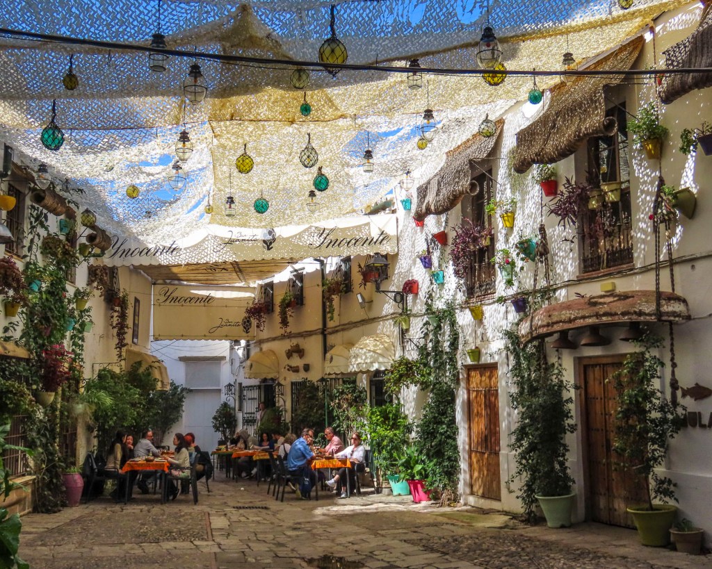
Following our host’s directions, we crossed the plaza and entered an arched alley that opened to the sky when it reached a small courtyard between the buildings. Shade netting strung across the alley created a picturesque play of light on the diners outside Bar Juanito.

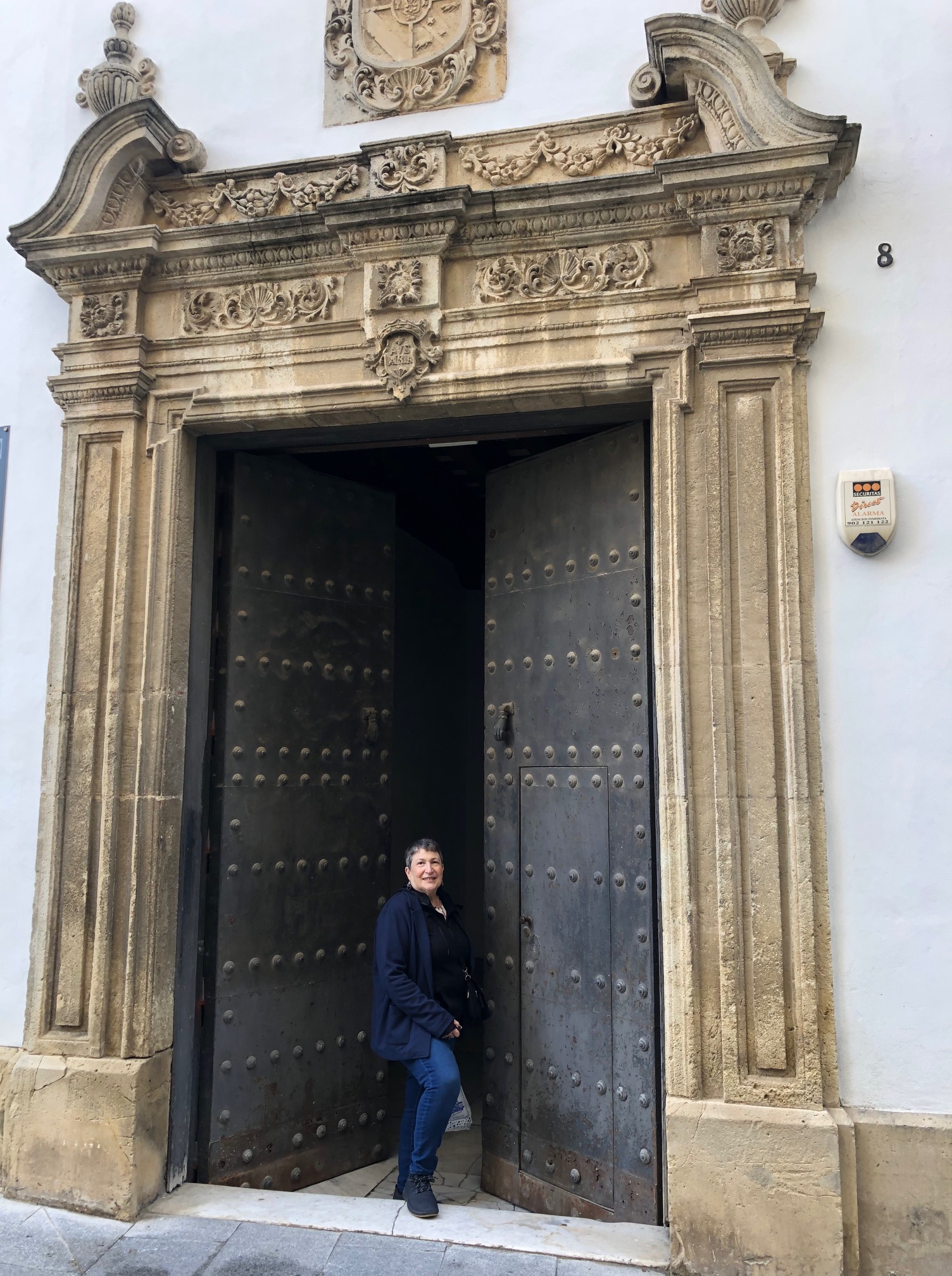
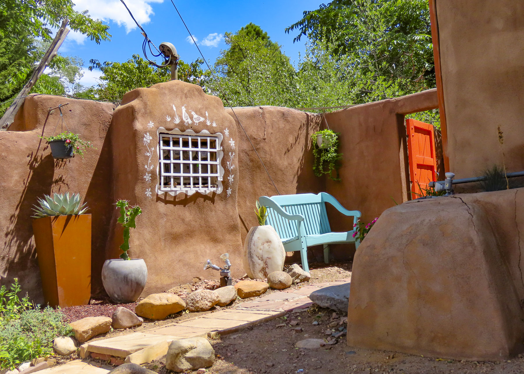
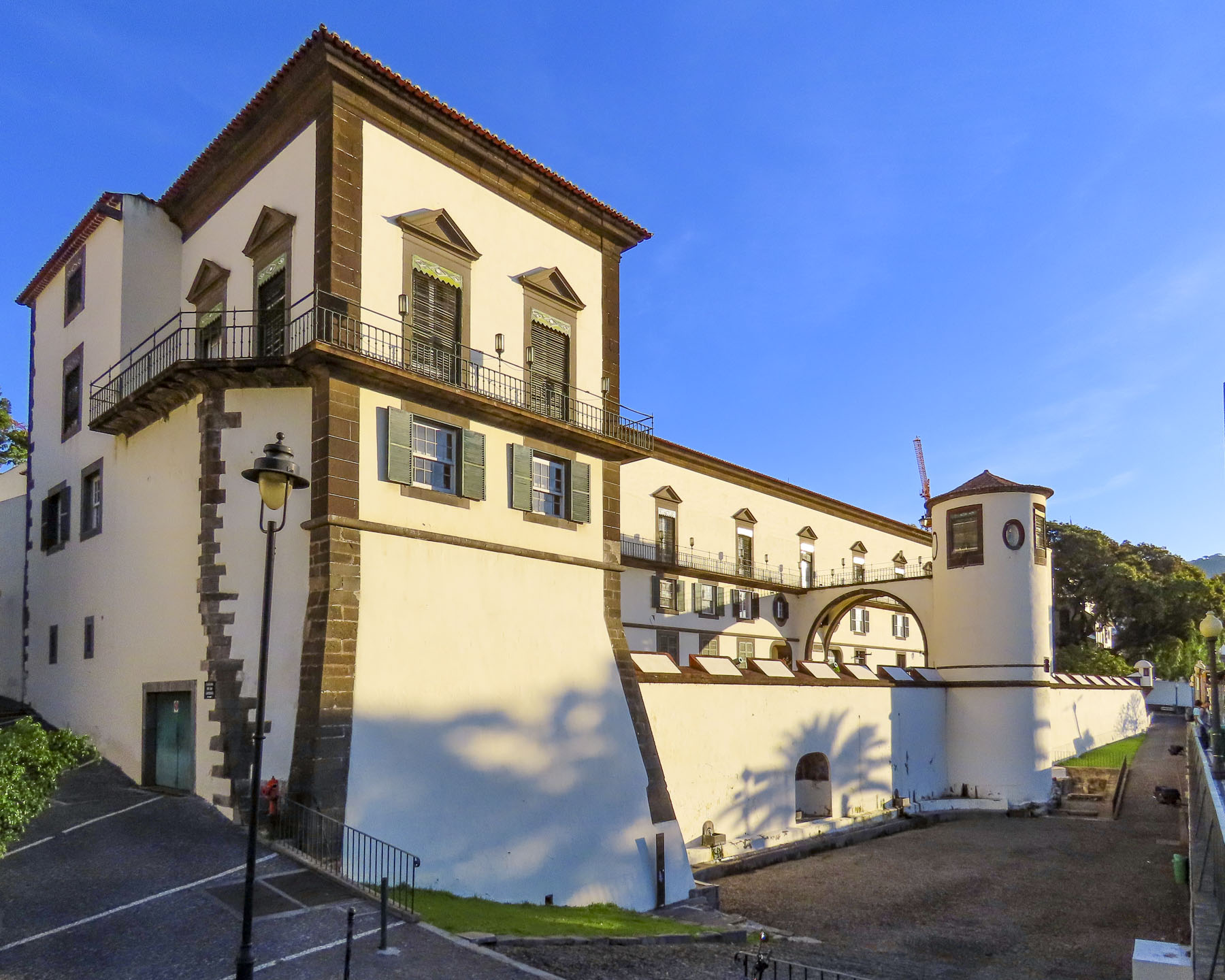
The restaurant was just around the corner from our lodging at the Palacio del Virrey Laserna, a 13th century palace that has remained in the same family for several centuries. While the name is quite impressive, being a palace and all, and it does have some nice antiques along with some interesting décor in the guest wing, it feels a little tired. Perhaps this is an unfair criticism for an ancient family home. A tour of the private part of the palace was included in our room rate. Sadly, they restrict photos in this part of the palace, which is filled with fascinating ancient memorabilia and furniture collected from Spain’s various colonies at the apex of its empire. Interestingly, in 1264, it was one of forty Moorish properties given as a reward to the knights that valiantly served King Alfonso X during the Reconquista of Jerez. Located only a short distance from the Alcazar, the old Moorish fortress, its proximity and size indicated it was once the home of an important Moor.

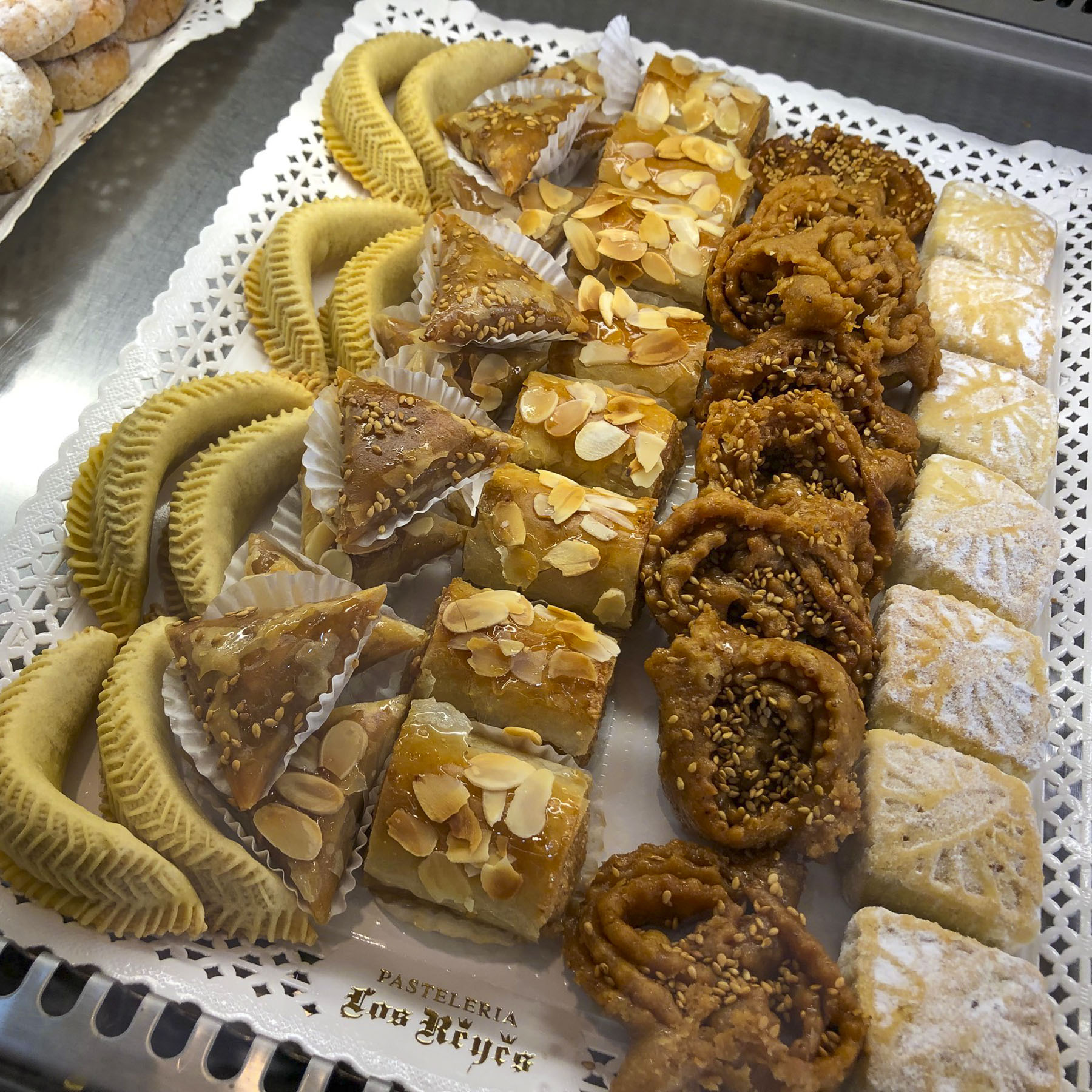
As nice as the ambience was on the Plaza the del Arenal, prices were rather steep, so the next morning we walked down a side street off the square to Los Reyes Pastelería. One of everything would have been our first choice. Yum!

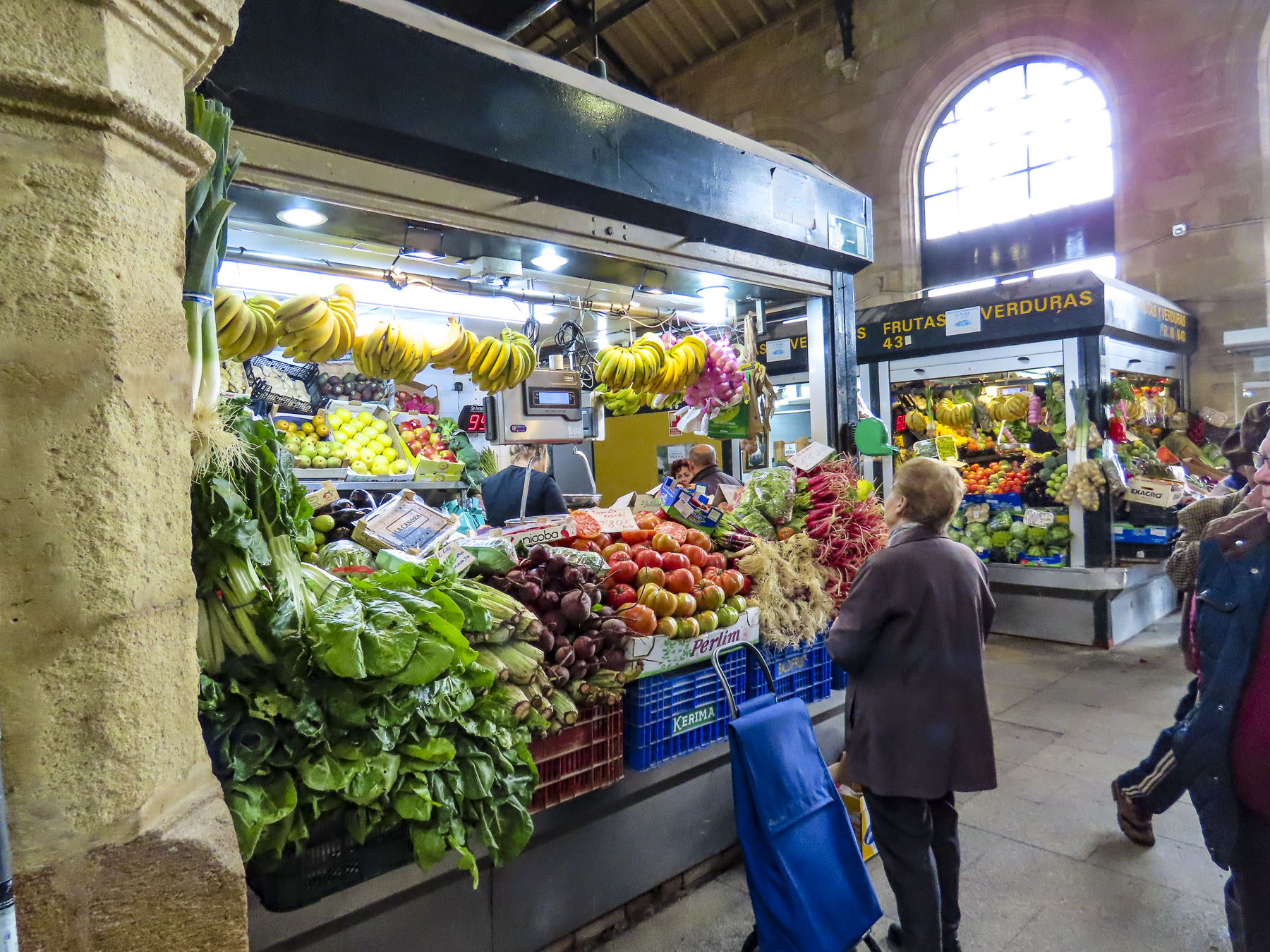
Later that morning we worked our way to the Mercado Central de Abastos, one of the oldest covered markets in Spain dating back to 1837. It has become part of our travel ritual to explore the central markets in the cities and towns we visit. The ones in Spanish cities close to the ocean are especially rewarding, as vendors display fresh seafood, shellfish, prawns and sea urchins. The Andalucia bounty doesn’t stop there. Olives, sausages, cheeses, and vegetables galore. And of course, jamon! The finest being named Pata Negra, in reference to their black hoofs. This jamon comes mostly from three villages, Jabugo, Cortegana, and Cumbres Mayores in the Sierra de Arecena mountains, two hours north of Jerez. Here the free-range pigs are raised on an organic diet of only acorns which imparts a unique flavor to the jamon. We made some purchases for a snack later.

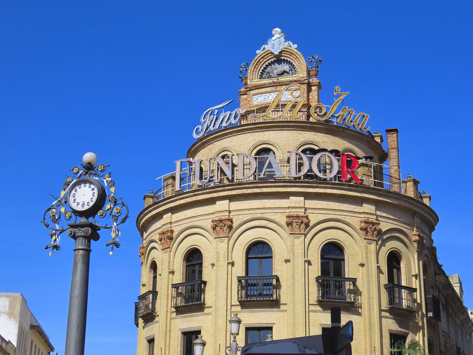
Around the corner from the market the iconic Fundador sign sits atop a historic building which is home to an equally famous 100-year-old bar named the Gallo Azul, or Blue Rooster. Known for its 6th floor semi-circular bar, interesting interior, and view of Jerez from its windows, it was unfortunately under renovation when we were in the city but is now open.

Walk a little then café was our philosophy as we wandered our way across Jerez towards Plaza de la Yerba and Plaza de la Asunción. There seems to be an infinite number of eateries across the city to the point that it feels like are more restaurants than retail shops. The dilemma is that they all look so inviting.

We were in Jerez several weeks before Easter and signs of Holy Week preparations were evident at the Plaza de la Asunción, where reviewing stands surrounded the plaza in front of the ancient City Hall and Real Iglesia De San Dionisio Areopagita. Built in 1575, during the reign of Felipe II, the façade of the old town hall is covered in ornate relief carvings depicting popular Renaissance motifs and is considered one of the finest examples of Andalusian Renaissance architecture. Though now, its weathered stonework is in need of some tender-loving care.

The church across the plaza stands in austere beauty by comparison, its simple 15th-century Gothic-Mudejar architecture the perfect backdrop for the monument to la Virgen de la Asunción, centered in the plaza before it. Interestingly, the monument was a relatively new addition to the plaza in 1952. It was created by the legendary religious sculptor Juan Luis Vassallo, from Cadiz, whose many monumental pieces can be seen atop buildings and in public spaces across Spain.

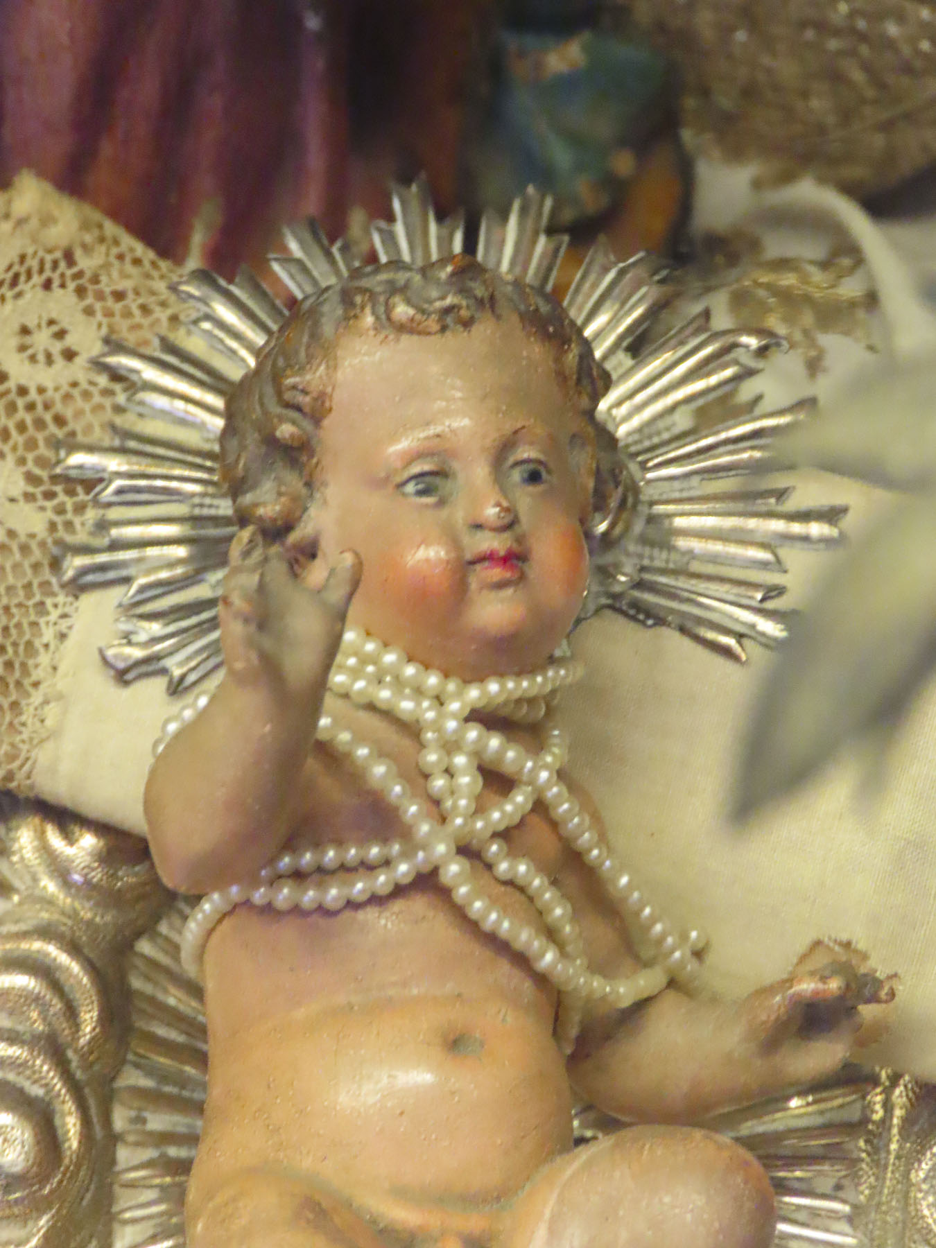
The church’s belltower was originally a civilian construction in 1447 to serve as a watchtower to spot attackers or fires. Several years later the town’s first public clock was installed on it. The inside of the church features an 18th-century baroque interior. In preparation for Semana Santa, the statue of the Virgin stood in one corner dressed in her ceremonial attire. Maybe it’s just me, but I think there was a Barbie as Scarlett O’Hara, from Gone with the Wind, theme happening?

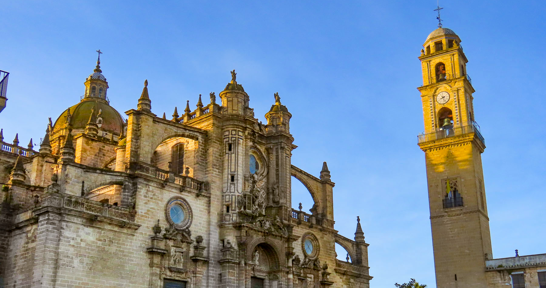
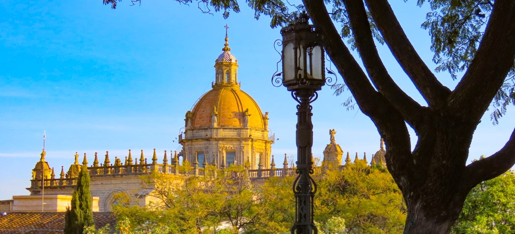
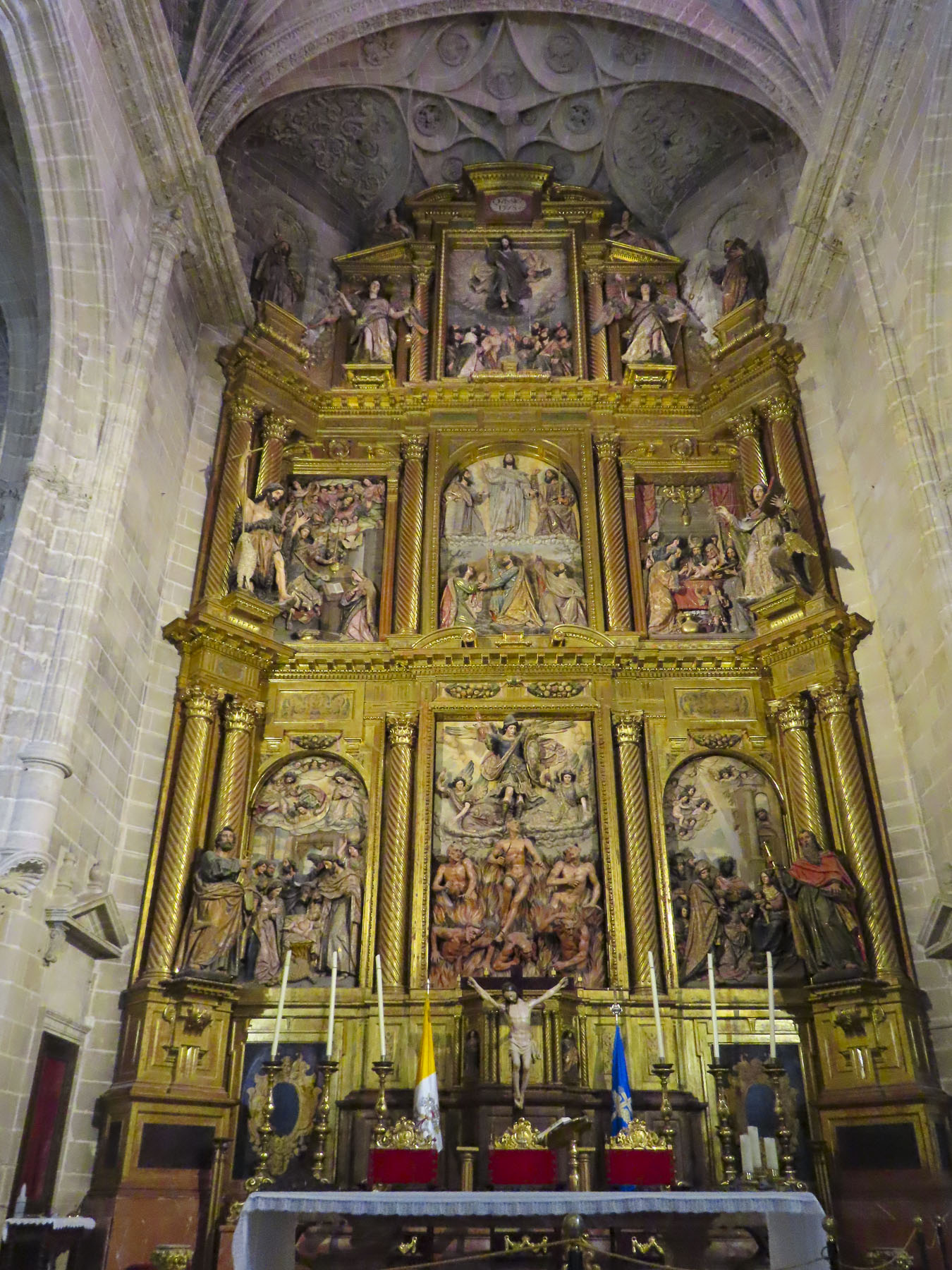
A huge church needs a significant name to match it and the Cathedral of Jerez de la Frontera / Colegiata de Nuestro Señor San Salvador successfully fills this obligation. It’s a massive structure supported with flying buttresses that we were able to get an aerial view of from the belltower across the way. It’s thought the belltower was reconfigured around a minaret that was part of the Great Mosque of Jerez before the reconquest.

With a special tax on sherry wine approved by the crown, construction of the cathedral was started in 1695. The first worship service was held sixty years later, but it would take another twenty years before the church was completed.

Inside the church is very austere, but voluminous. The soaring ceilings of the cavernous space is supported by monumental Corinthian columns, the width and height of giant sequoia trees. The huge doors on the ends of the naves dwarfed us. It was an enormous engineering feat.

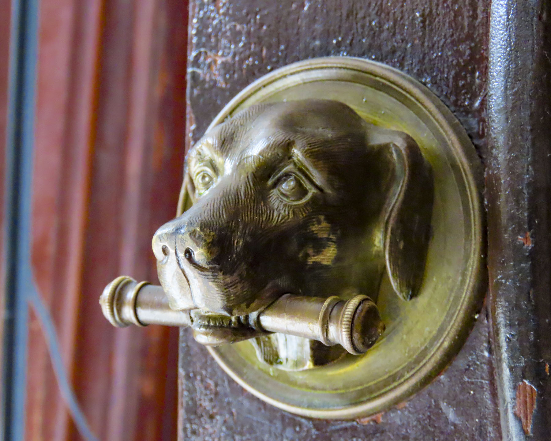
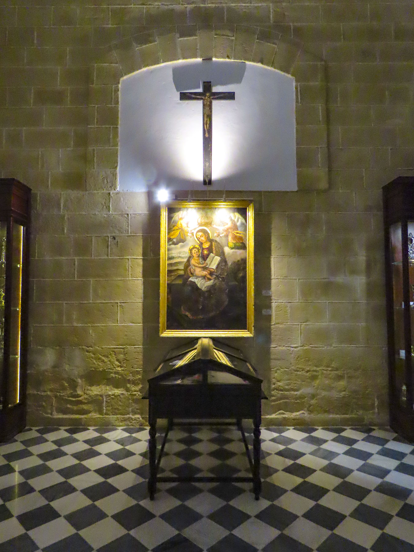
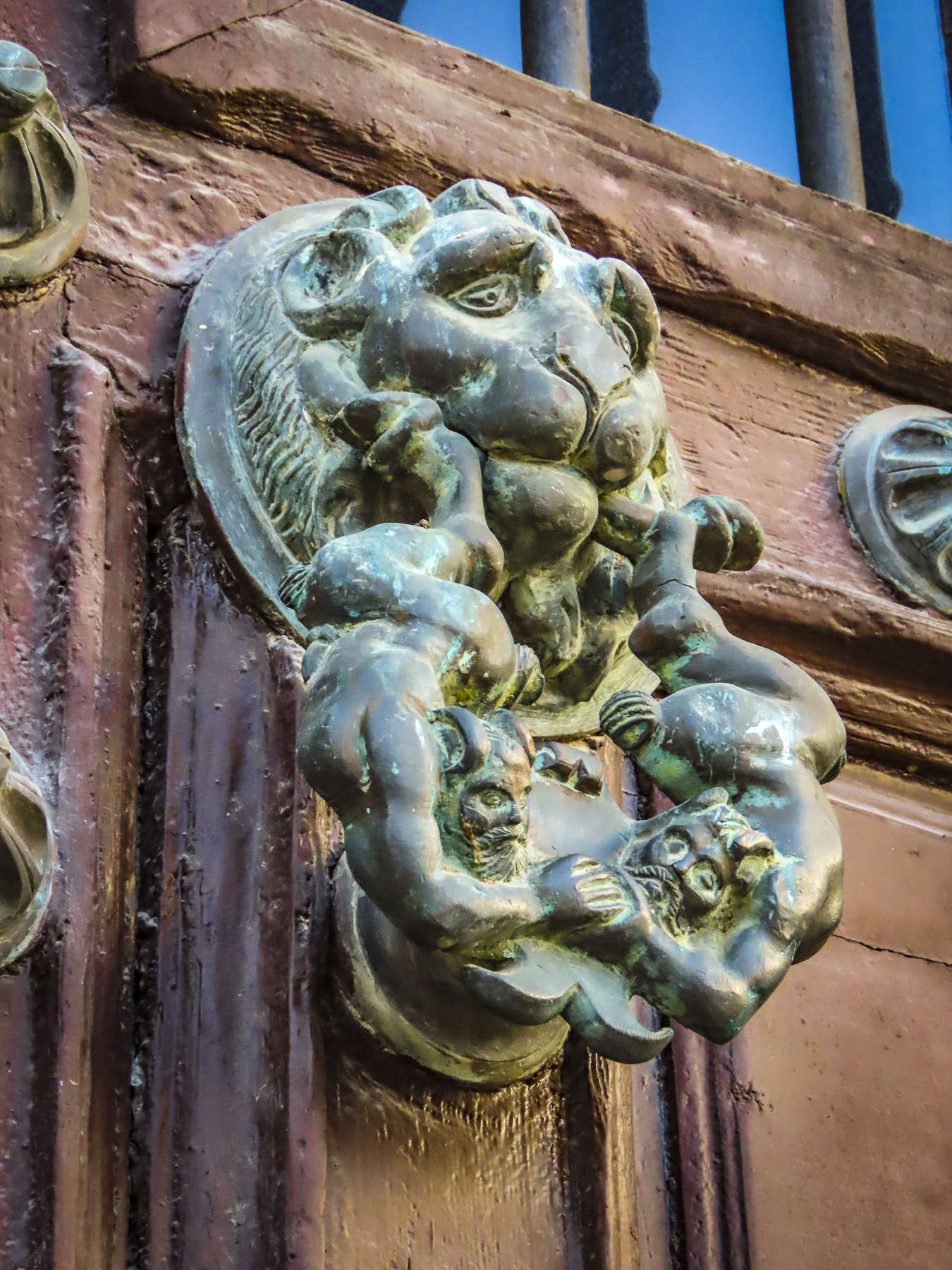
The sacristy was interesting with a display of the church’s treasure. The old-world craftsmanship in the archaic religious objects was amazing. An odd detail was two doorknobs sculpted as dog heads. We asked the attendants if they knew the story behind them, but no. They were a playful insight into the mind of God’s representative in Jerez. In one corner a small alcove revealed a nautilus staircase that spiraled aloft. Disappointingly, it was roped off and Donna was unwilling to create a diversion for me to explore further.

Walking by along the bodegas of Gonzalez Byass, famous for its sherry aging warehouses, we made our way through a lovely, shaded park to Taberna La Sureña, a small tavern across from the Alcazar. “No se permite hablar de política, religión o deportes,” roughly translated as no talk of politics, religion or sports allowed, was wisely written in chalk above the bar. It’s a small space with only three tables inside and three on the sidewalk. We snacked on two local cheeses with sausage, crunchily addictive picos (a mini dry bread stick,) and our first taste of vermut, or vermouth, that wasn’t part of a martini. It was a wonderful, flavorful revelation. Though sherry and vermouth are considered fortified wines because brandy is added after fermentation, vermut additionally gets infused with spices and aromatic herbs. Flavorful and complex, the local vermut became our wine of choice during our trip through Andalucia.

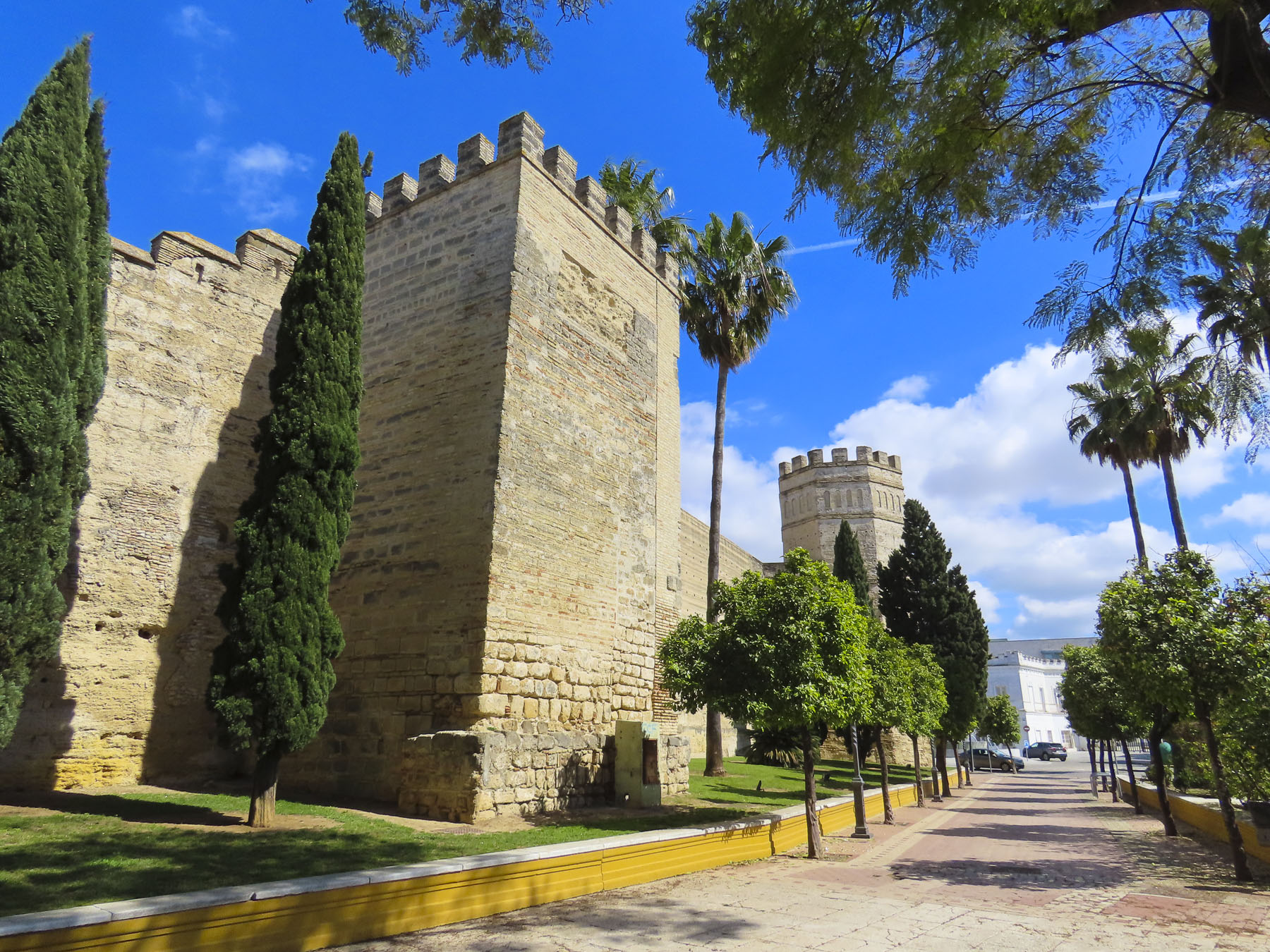
Across the way the Alcazar of Jerez beckoned for exploration. The history of all the towns in Andalucia is complex, with loosely associated tribes, Phoenicians, Romans, Vandals and Visgoths. It wasn’t until the Moorish rule of the region between the 8th and 13th centuries that Jerez underwent a period of great urban development. It was during this time that the city was ringed with a defensive wall and the Alcazar was expanded to become a fortified palace and city-within-a-city, with its own separate economy, supported by a granary, warehouses and olive presses. With the Christian Reconquista in 1264 the Alcazar became the seat of the first Christian mayors of the city and the palace was used by royal visitors. The addition de la frontera (“of the frontier”) to cities’ name reflects that this was a hotly contested region, with an expanding and contracting border for many decades.

The discovery of the Americas in 1492 brought prosperity with the export of wine to Spain’s colonies in the New World. Interestingly a conquistador from Jerez, lvar Núñez Cabeza de Vaca, survived an ill-fated expedition which explored from the gulf coast of Florida to Texas. Surviving capture and enslavement by Indians, he and three compatriots trekked across the wilderness for eight years before being reunited with fellow Spaniards along the Gulf of Baja on the Pacific coast of Mexico. In his book La relacion y comentarios del gouernador Aluar Nuñez Cabeca de Vaca, the documenting of the native American tribes he encountered is so unique that he is regarded as the first ethnologist of the American southwest.

The ancient olive oil press at the Alcazar is huge. Touring the supporting production rooms with smaller presses and underground ceramic storage vats reinforced the importance of olive oil to the local economy centuries ago. A path through the gardens led to the old hammam. Centuries ago, it must have been quite an impressive structure with cool and hot baths, surely a luxury back then. The scale of the hammam is best seen from atop the fortress walls, some of which were constructed using a rammed earth technique.

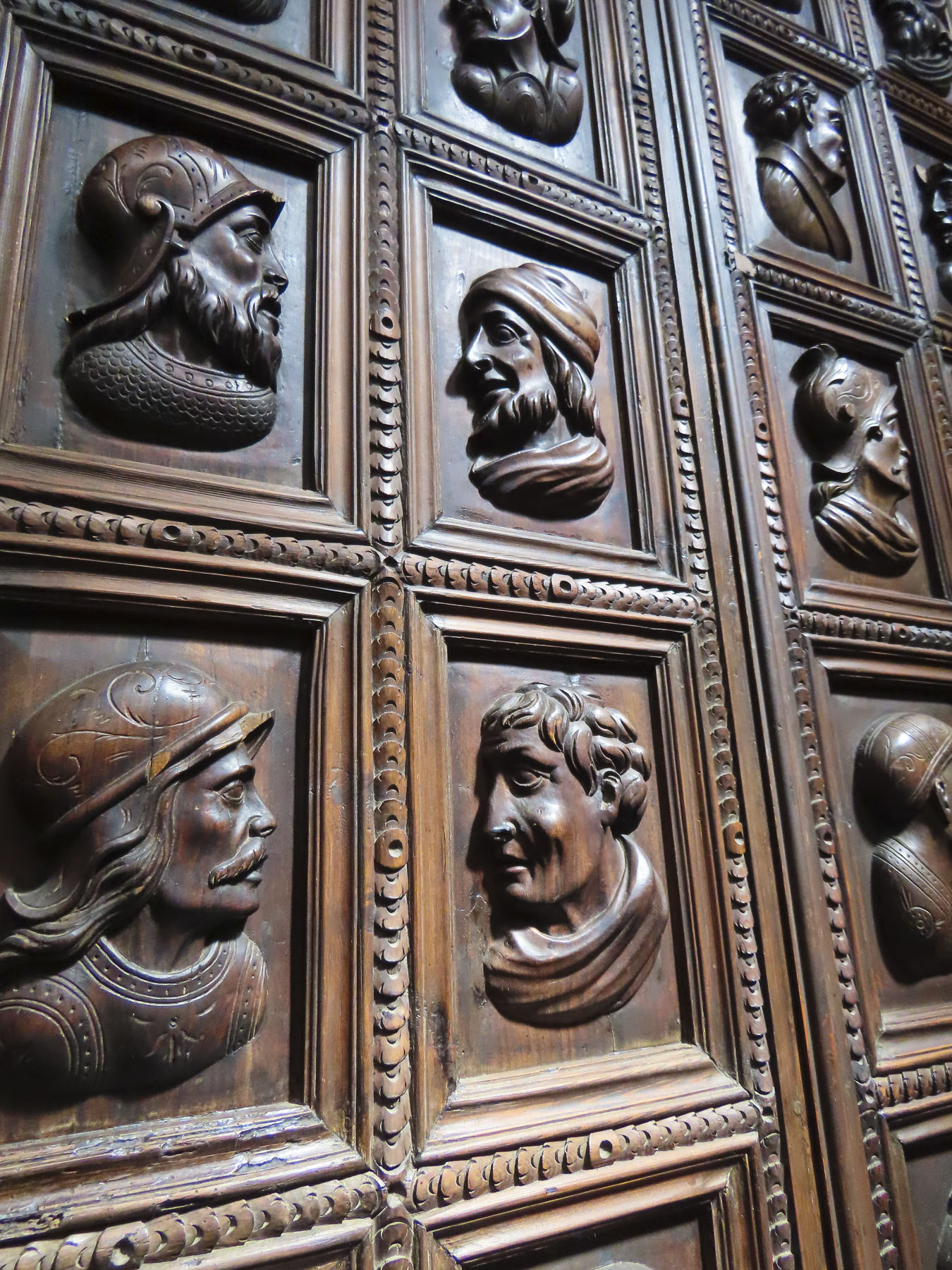
We found the palace, renovated to a utilitarian boredom, the least interesting part of the grounds. Though it did have an intriguing set of wood doors carved with the profiles of famous citizens. And on the highest level there is a nice view of the Cathedral of Jerez across the park.

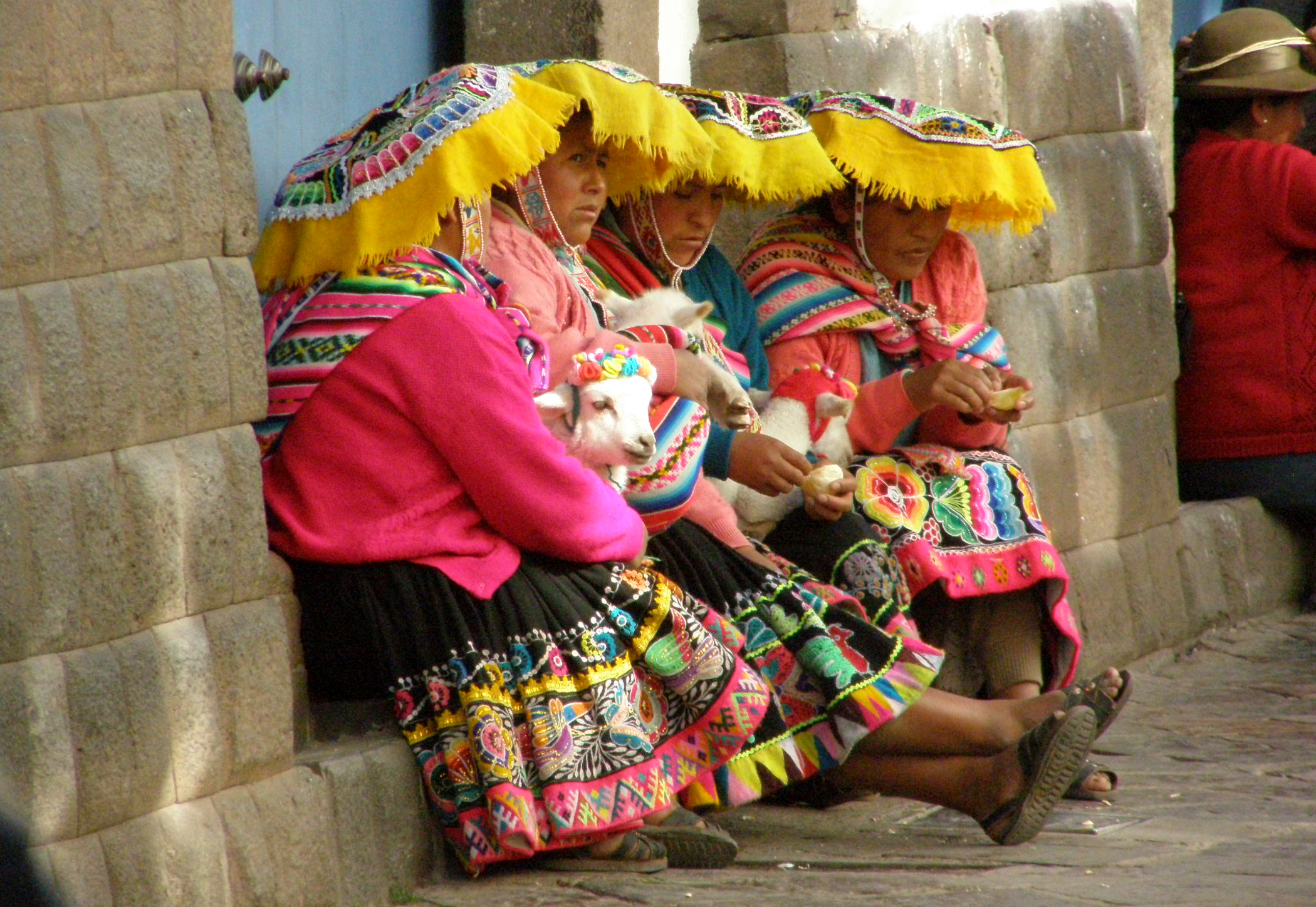
Later that evening as we strolled across town in search of elusive Alcauciles Fritos (Fried Baby Artichokes) we happened upon one of the cities’ brotherhoods practicing marching with a weighted platform before the big events of Holy Week. With military precision they followed their captain’s instructions and performed a switchback maneuver through restaurant tables that nearly blocked their route.

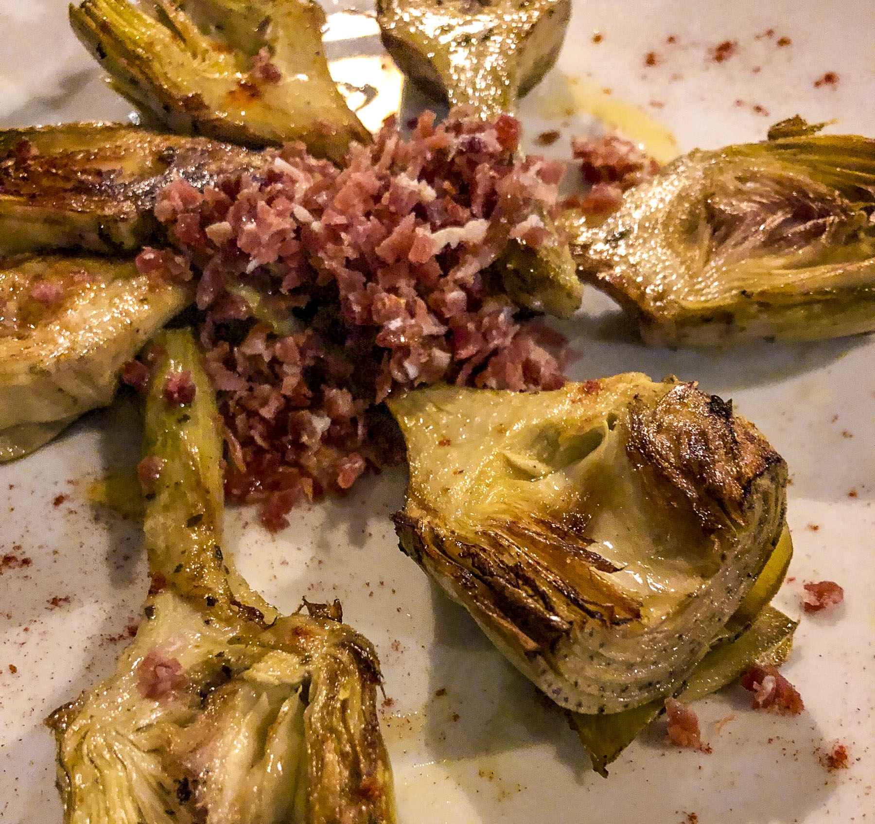
Down a side street near the central market, we found Tabanco La Reja, a small tapas bar far removed from the center of the city, that’s known for its local fare. The young seasonal artichokes are sprinkled with lemon juice and sea salt, then pan fried in oil over high heat until the stalks and hearts are tender, and the juices caramelized to set the flavor. They were sublime.  Flamenco music from a tabanco across the calle drifted in, the vermut was good, the evening was perfect.

Strolling back to our hotel, concert music filled the street as we passed the Iglesia Conventual de San Francisco, drawing us inside. A Brotherhood band was playing to a full church. Another pre Semena Santa event that charmed us.

Churches, churches, churches. Spain, Italy, Portugal. Everywhere a church They share that history of religious influence that so dominated the emergence of European kingdoms during the Middle Ages and Renaissance. Princes and paupers donated for that access to the stairway to heaven, enriching the church with grand architecture, priceless art, and jeweled encrusted religious iconography. Which is exactly why we visit so many of them. “Follow the money, it’s where the art is,” is how I like to phrase it.

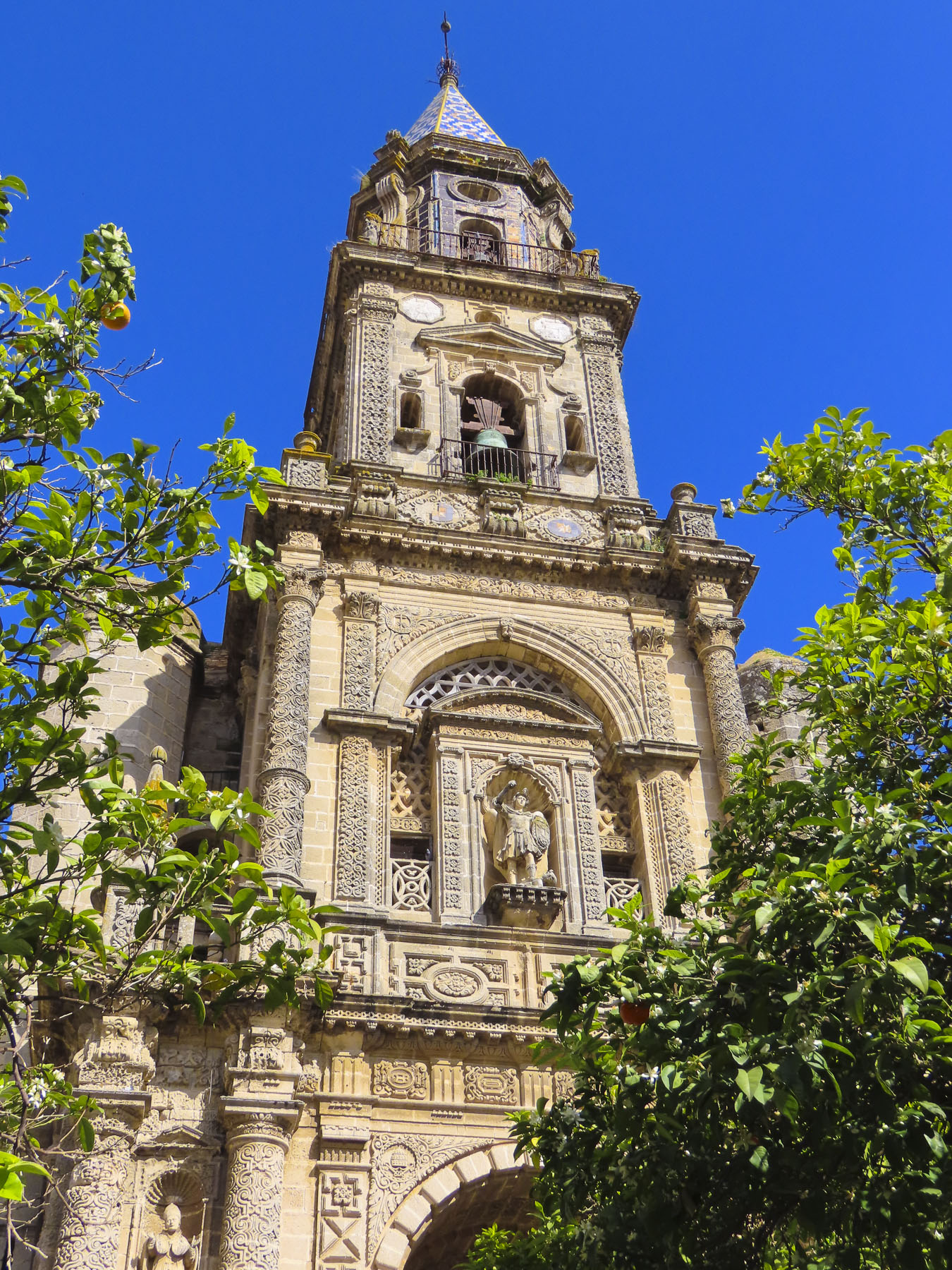
Covered in highly detailed baroque relief carvings, the Iglesia de San Miguel stood magnificently before us. Though much smaller than the Jerez Cathedral, the façade of this church and belltower are stunningly beautiful.

And the inside feels more intimate with a modest gilded altar. But we could only speculate on the hell fire and brimstone sermons that might have been delivered here based on a fiery retablo which dominates the church. Created by master sculptors Martínez Montañés and José de Arce, in the 17th Century, it depicts the Archangel Michael fighting very realistic devils.

Across from the church the sequestered nuns of the Convento San José Franciscanas Descalzas still operate a dulces turno, a lazy susan type cabinet, in the wall of the convent from which they sell pastries and cookies made from ancient church recipes to support themselves. It’s handy to have paper and pen to write down what you want from a list that hangs on the wall, or to use the translator app on your phone. It’s a wonderful centuries-old tradition that continues in many convents across Spain.

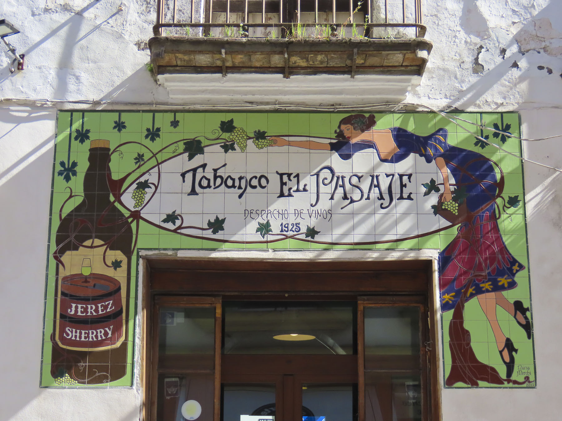
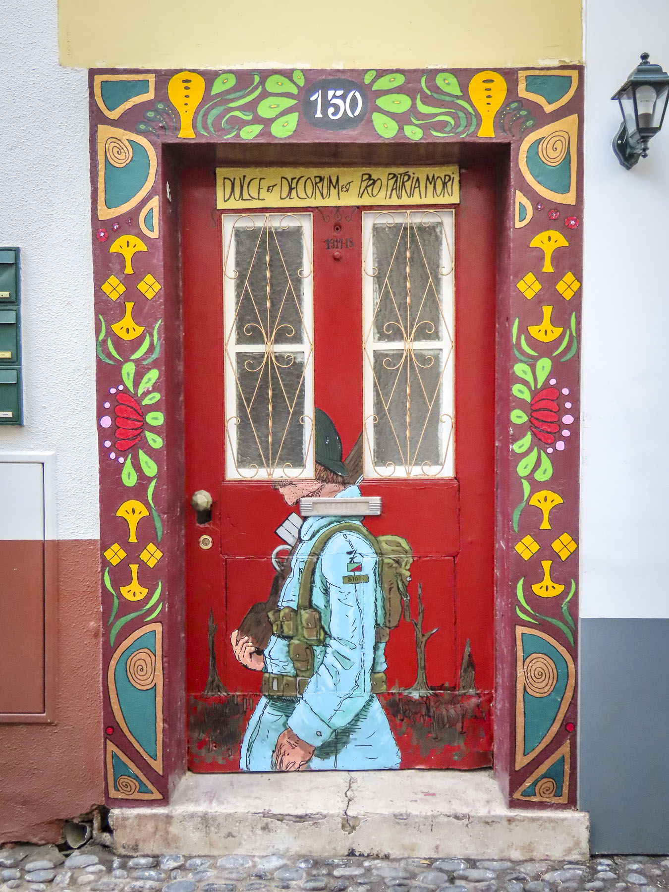
Scattered across Jerez are colorful ceramic advertising murals that usually highlight various sherries. They are all very artistic and seem to be unique to Jerez.

Touring a sherry bodega, a wine cellar, is a must in Jerez and there are several vintners in the city that offer tours, then tastings at their facilities. We chose Bodega Tio Pepe at Gonzalez Byass, basically for its convenience to other historic sites nearby. And we do admire their iconic Tio Pepe logo and advertising.

The bodega was started in 1835 by a young 23-year-old businessman, Manuel María González Ángel,  who had no experience creating wine, but he enlisted the help of his beloved Uncle Pepe to show him the ropes. Their first sherry was well received, especially in England. In appreciation for his uncle’s expertise González named their sherry Tio Pepe, “Uncle Pepe.” The iconic logo was created in 1935 , and shows a bottle dressed with a wide-brimmed hat, Andalusian jacket, and Spanish guitar to celebrate the company’s 100th anniversary. It soon became one of the world’s most recognizable advertising logos. The sherry is exported to 115 countries around the world.

The tour through the old bodegas was very interesting, as the guide explained that tiered casks never get completely emptied. The ready-to-drink aged sherry is siphoned from the bottom barrel until it is one-third-full. It is then refilled with less aged sherry from the cask above. The procedure is repeated until new wine is added to the partially emptied top cask. From start to finish the aging of sherry takes four years. In keeping with the times, the tour ended in a very hip tasting area that features various configurations of the Tio Pepe logo.

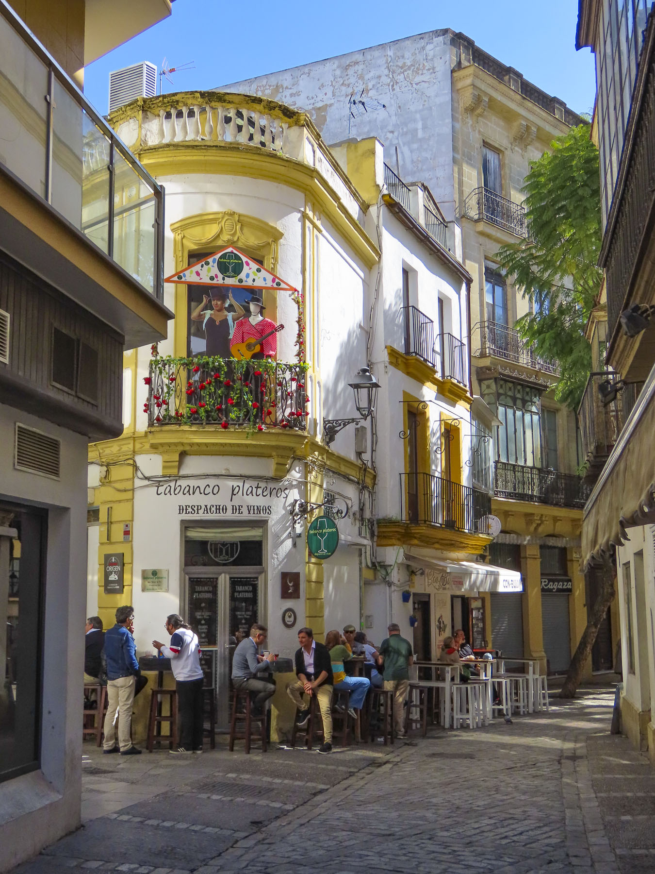
Most worthy restaurants in Jerez don’t open until 8:00PM and then seem to instantly fill up, with patrons spilling onto the street. If you have a particular spot in mind, our suggestion is to arrive when it first opens, as many do not take reservations, or try dining there for lunch. The good news is Jerez takes its cuisine very seriously and there are few places geared toward tourists. The most popular street we found was Calle San Pablo, a narrow alley filled with lively tapas bars. It’s located between the Iglesia de San Miguel and Plaza del Arenal. A walk along Calle Consistorio which starts at the plaza will also lead you past many places that will whet your appetite.

Jerez de la Frontera has a wonderful tranquil ambience. Historic with a cosmopolitan flare, the city is often overlooked by folks visiting Andalucia. This is a blessing for those that enjoy its charms.

“If God had not made Jerez, how imperfect would his work be!” – Benito Perez Galdos.

Till next time, Craig & Donna

Peru: The Inti Raymi Festival – An Ancient Celebration Revived

The precision stone masonry of ancient Inca craftsmen lined narrow alleys, and slowly began to come to life with Quechuan women dressed in their colorful attire. They were clutching baby llamas and claiming spots to pose for photos with tourists. It would be a busy day. The Plaza de Armas, the historic center of Cusco, would soon be packed with spectators for the Inti Raymi Festival.

This nine day long ancient Inca ritual traditionally celebrated the Sun God, Inti, on the winter solstice in the southern hemisphere, June 21st, but is now observed on the feast day of Saint John the Baptist, June 24th, in an attempt to blend beliefs. The celebration marks the beginning of a new life cycle with the approach of Spring and warmer weather for the planting of crops to begin another agricultural year. We wanted to scope out the plaza early and find a spot with an unobstructed view of the activities.

In ancient times the ritual began at Coricancha the Temple of the Sun, now the Convent of Santo Domingo since the Spanish conquest of Peru. Talented astronomers, the Inca built the temple in the 1400s for one portal to celestially align with the rising sun on the winter solstice and brilliantly fill the gold covered interior with light.  

After watching the sunrise and receiving this blessing, the Inca ruler as the Sun God’s earthly representative would thank the Sun God for the last year’s harvest and request his light shine upon the Inca Empire favorably for another year.

He was then carried ceremonially on his throne atop the shoulders of warriors across Cusco, followed by other members of the royal Inca family, the mummified remains of previous Inca emperors and delegates from hundreds of different tribes that inhabited the vast Inca Empire that spanned from Columbia, Ecuador, Bolivia, Chile, from the Pacific coast over the Andes to the Amazon jungle, representing a rainbow of people, a theme that today is incorporated into the city flag of Cusco.

Conquistador Francisco Pizarro captured Atahuallpa, the 13th and last Inca emperor. Atahuallpa offered a room filled with treasure for his freedom, and the Spanish accepted. The walls of Coricancha and other temples across the Inca Empire were stripped of their gold and silver, which was then melted into bullion and sent to Spain on the famous treasure fleets that plied the Atlantic from 16th to the 18th century. The Spanish executed the Emperor when he refused to convert to Christianity in 1533.

The Spanish banned the Inti Raymi as a pagan event. But the tradition went underground and was observed in secret, in isolated villages throughout the Andes. The festival was revied in 1944, mostly due to the efforts of two proud Quechuans, Faustino Espinoza Navarro (a scholar and artist) and Humberto Vidal Unda (a future mayor of Cusco and a leader of the Indigenismo movement, which advocated for native political involvement.)

Researching historic chronicles such as Royal Commentaries of the Inca by Garcilaso de la Vega (1612), the illustrated book The First New Chronicle and Good Government by Felipe Guamán Poma de Ayala (1615) and a manuscript by friar Martín de Murúa, The Historia General del Piru (1616), that also contains illustrations, Navarro created a script and Unda envisioned the theatrical staging for a cast of 800 performers.

The event has grown over time and now includes 25,000 participants drawn from hundreds of Peruvian indigenous groups, who dress in their unique regional garments parade, dance, and sing their way through Cusco and the Plaza de Armas. They then continue uphill to the ruins of Sacsayhuaman fortress, overlooking Cusco.

In this open expanse above the city roughly 80,000 people gather to watch all the participants fill the field for the grand finale, which depicts simulated animal sacrifices, pledges of loyalty to the Inca emperor from all the tribes, and final offerings to the Sun God. This is the second largest festival in South America, after Carnival. It was a dynamic and colorful event that was a joy to experience.

Till next time,

Craig & Donna

A New Mexico Road Trip: Earth, Sky, & Art

One of the things we enjoy most about traveling is picking the brains of folks we’ve had the pleasure of meeting throughout our journeys. Whether it’s a tip from a car rental agent about an isolated restaurant in the Azores or from a young Italian attorney who shared her love of Cadiz, Spain, with us, we try to follow through. Sometimes acting immediately, but mostly tucking the tips away into the deep recesses of our minds to consider in the future.

When the same question is asked of us about the best places to see in the United States, Albuquerque, Santa Fe and Toas in New Mexico immediately top our list as the most unique destination in the USA. Maybe I’m a little cynical with an over-simplified view that the United States is mostly a homogenized mass of sameness that spans 3000 miles from the Atlantic to Pacific, mostly sharing the same landscapes, urban architecture, and strip malls with the same ubiquitous retailers – Home Depot, Starbucks, Panera, Pizza Hut and McDonalds – from coast to coast. Yes, the same is true, though to a much smaller degree, of the urban sprawl that surrounds Albuquerque. Though here you’ll find Blake’s Lotaburger, frito pies, piñon coffee, frybread-style sopapillas, and pozole (a hominy dish) along with parking lots filled with roasters full of Hatch green chilies every September when the harvest comes in and that wonderful aroma fills the air. We hope these photos and this story pique your interest in New Mexico, an endlessly beautiful, culturally diverse, artistic, and quirky place that is truly the “Land of Enchantment.” And a destination we always enjoy exploring.

Start in the Petroglyph National Monument, then follow Central Ave (Old Rt66), from the original adobe buildings of Old Town, circa 1706, east across town up to the Knob Hill area around the University of New Mexico and beyond to the Tijeras Pueblo Archaeological Site and the beginning of The Turquoise Trail. You will have spanned several millennia from the oldest petroglyphs dating from 2000 BC to the present and a blending of cultures that is refreshing. It’s a remarkable stretch of history for a young country that typically dates itself to the English colonies of Jamestown – 1607, and Plymouth – 1620.

A 2013 archeological excavation in northern New Mexico unearthed stone tools used to butcher a mammoth, and radiocarbon testing dated them to be 36,000 years old. These tools are attributed to some of the first people that migrated across the Bering Sea from Asia, the ancestors of Native Americans. Jump forward 35,000 years and you have pueblo Indians living in settlements along the Rio Grande Valley and across northern New Mexico. Their first contact with Europeans comes with a back story and cast of characters worthy of the best fiction writers.

It starts with orders from the Holy Roman Emperor Charles V (Charles I of Spain) to Álvar Núñez Cabeza de Vaca (from Jerez de la Frontera, near Cadiz, from that great tip earlier) authorizing him to colonize the region between Río Soto la Marina, Mexico, and what is now Tampa, Florida, a distance of 1500 miles. Tragically believing the distance between the two was only 45 miles, Cabeza de Vaca landed north of Tampa in April 1528 with 300 men and forty horses. Unable to rendezvous with their ships, the expedition was doomed. Traveling west across the top of the gulf towards the nearest Spanish settlement of Tampico, Mexico they encountered alligators, venomous snakes, and hostile natives. They were captured, enslaved, beset by disease-bearing mosquitos; they crossed numerous creeks, swamps and rivers. By the time they reached the “Isle of Misfortune,” Galveston, Texas a year later, only 15 remained.  They crossed the Rio Grande near El Paso. With the help of friendly tribes, Cabeza de Vaca and three others, Alonso del Castillo, Andrés Dorantes de Carranza, and his slave Esteban the Moor survived an eight-year Homeric ordeal, that took them across the Mexican desert to the Pacific Ocean before being reunited in 1536 with their compatriots in Mexico City. The three Spaniards were rewarded with titles and land by the King. Cabeza de Vaca became the Viceroy of Paraguay, gained political enemies and was unjustly tried in Spain and imprisoned in North Africa. It is not known if Esteban the Moor was granted his freedom, but he was not forgotten.

De Vaca and his fellow survivors had returned with legends heard from the Indians they encountered of fabulous riches farther inland. These stories of insurmountable wealth were still fresh in everyone’s minds two years later when Friar Marcos de Niza (from Nice, France) arrived in Mexico City after leading the first groups of Franciscans into Peru with Spanish conquistadors to conquer the Inca civilization. In hope of finding the fabled “Seven Cities of Gold,” a treasure that allegedly rivaled that of the Aztecs and Incas civilizations, the Viceroy of Mexico planned an expedition headed by Friar Marcos de Niza, along with Esteban the Moor who had the most knowledge of the area’s tribes, and their customs. It seems from reading various accounts that Esteban led, and Friar Marcos followed. They both were the first foreigners, a North African slave and a European, to explore the area we now recognize as the American Southwest. This is 27 years before the founding of St. Augustine, in Florida in 1565. Friar Marcos claimed Esteban the Moor was killed near a Zuni pueblo when he reached one of the “cities of gold.” Marcos also claimed to have seen a city larger than Mexico City, with buildings nine stories high glittering on the horizon. Dream, mirage, a pueblo glowing like a sunset – a lie? Wanting to avoid Esteban’s fate, the Friar ventured no further and returned to share his exploits in Mexico City. The lust for gold was consuming and a year later, in 1540, Francisco Vázquez de Coronado led an expedition of 400 hundred soldiers with 1500 native porters and Friar Marcos north again to attain that treasure. And boy was he miffed when they reached the Zuni tribe and found nothing but a “poor pueblo.” Accusing Friar Marcos of lying, he sent him back to Mexico. Coronado’s expedition would stay in the region for two years, traveling in several smaller groups west as far as the Grand Canyon and east into Texas and Kansas. They never discovered gold though they did travel through areas where it would be discovered centuries later. They returned emptyhanded. It would be 53 years before Spaniards ventured north again.

In 1595 King Philip II of Spain chose Don Juan de Oñate to colonize the upper Rio Grande valley. In 1598 he led an expedition north that included 20 Franciscan missionaries, 400 settlers, 129 soldiers, 83 wagons, plus livestock, with the stated mission from the Pope to spread Catholicism. But there was still hope that the evasive “Seven Cities of Gold,” would finally be discovered. Fording the Rio Grande near present day El Paso, he proclaimed all the lands north of the river “for God, the Church, and the Crown.” Life in the new territory under Oñate was severe. Some settlers urged a return to Mexico when silver was not discovered, and Oñate executed the dissenters. Pueblos that refused to share winter food stocks needed for their own survival were brutally suppressed into submission. The Spanish imposed the encomendero on the pueblo tribes. This was a colonial business model that granted conquistadores or ordinary Spaniards the right to free labor and tribute from the indigenous population. In return Nuevo México encomiendas were obligated to “instruct the Indians in the Roman Catholic faith and the rudiments of Spanish civilization.” The free land and free Indian labor promised with the encomendero was also used as a recruiting tool to encourage settlers to venture north from Mexico. The pueblos did not submit willingly; any resistance was forcibly repressed until the Pueblo Revolution in 1680. Four-hundred Spaniards died, including 21 priests, but there were almost 2000 Spanish survivors. Warriors followed the fleeing refugees all the way to El Paso to ensure their expulsion from Indian territory. But by then there were three generations of intermarriage, along with shared ideas, technology and customs.

When the Spanish returned 12 years later, they did not try to reimpose the encomendero, and returning missionaries displayed more tolerance of indigenous religious beliefs. Spain instead sought to enlist the Pueblo tribes as allies to resist French and British empire expansion farther west. The vast area claimed by Coronado and Oñate became part of the United States with the Treaty of Guadalupe Hidalgo, which ended the Mexican-American War in 1848. It’s a fascinating multilayered history that continues to contribute to New Mexico’s uniqueness.

But enough about history. Land at the Albuquerque International Sunport, rent a car and hit the road. Head north on Rt25, with the Sandia Mountain Range glowing in the late afternoon light on your right and a spectacular sunset in the west. This sublime experience could be the beginning of a long love affair with the state, as it was for us. The expansive vistas and sky, along with incredible light and dramatic ever-changing weather out here are just awesome, especially if it’s your first time to the Southwest. Fair warning: the state can become addictive with endless ways to satisfy your wanderlust.

The ruins of the old Spanish missions in the Salinas Valley and Mountainair are south of Albuquerque. Route 40 East will take you to the beginning of the Turquoise Trail, a splendid backroad route that gracefully curves, rises and falls through the rugged foothills of the Sandia and Ortiz mountains as it follows NM14 north for 65 miles. Pass through the historic towns of Golden, Madrid, Cerrillos and San Marcos just south of Santa Fe. Follow Route 40 West to see the amazing rock drawings at the Petroglyph National Monument or continue farther to the Zuni Reservation, mentioned earlier.

Veer off Rt25 and head to Jemez Springs where you’ll find, red rock canyons, old logging roads and hot springs. Farther along in the Valles Caldera National Preserve you can see herds of elk grazing in a 13-mile-wide meadow that is now all that remains of a collapsed volcano cone after a massive ancient eruption.

Nearby the 11,000-year-old cliff dwellings carved into the canyon walls of Bandelier National Monument are a must stop. There are plenty of interesting detours and quirky stops to make along the way.

Santa Fe and Toas lie in the mountains farther north of Albuquerque and have been popular destinations with artists and writers since the early 1900s – D.H. Lawrence, Georgia O’Keefe and Ansel Adams and many others enjoyed the vibrant Indian and Hispanic cultures. Today Hollywood stars like Julia Roberts, Val Kilmer, Ted Danson, and Oprah Winfrey have homes in the area.

The city retains it early Spanish heritage with historic adobe buildings surrounding Santa Fe Plaza. The Indian market is still held under El Portal in front of the Palace of the Governors, the oldest continually occupied public building in the United States, since its construction in 1610.

The region continues to support artists and craftspeople with numerous galleries, festivals, and fairs. A stretch of 80 art galleries in old adobe buildings along Canyon Road belies its ancient roots as part of El Camino Real, The Royal Road, that ran 1600 miles to Mexico City. Famously Spanish settlers from Mexico introduced chili peppers into the region via this ancient trade route.

The landscapes north of Santa Fe continue to be intriguing, with Black Mesa, sacred to Native Americans, and the Puye Cliff Dwellings which run along the base of a mesa for over a mile. Stairs and paths cut into the cliff face led to adobe structures atop the mesa’s plateau. East of Espanola, the Santuario de Chimayo, built in 1816, still attracts pilgrims seeking miraculous cures from its “healing dirt.”

Heading into the mountains of northern New Mexico, the durability and sustainability of well-maintained adobe structures are evident in the elegant San Francisco de Asis Catholic Mission Church in Rancho de Taos, which dates from 1772.

Impressive Taos Pueblo, a multi-storied residential complex, has been continually occupied since its construction in the 1400s. Today nearly 150 people continue to live traditionally in the pueblo, as their ancestors did, without running water or electricity.

Nearby the Rio Grande River Gorge fractures the earth like a lightning bolt. The view from the center of the bridge looking down into the chasm is magnificent and terrifying. Farther north as the river rises from the gorge it has a totally different character as it meanders through the high desert.

While this far north, it’s worth the effort to visit the Great Sand Dunes National Park and Preserve, located just across the state line in southern Colorado.

Over many thousands of years, sands blown across the high desert plains accumulated at the base of the Rocky Mountains here to form the tallest dunes in North America.

Wave when you see us!

Till next time, Craig & Donna

Nicaragua: The Dioromo Hipica – a Horse Parade

Celebrating the equestrian lifestyle has been a Spanish tradition since the Middle Ages and followed early Spanish colonists across the Atlantic to Central and South America in the 1500s. In Nicaragua the tradition lives on in beloved hipicas, horse parades.

There are numerous Hípica festivals, held in towns large and small, across the country throughout the year. They are usually the main event of a town’s festivities marking their patron saint’s day. By pure luck, one February, we were able to experience the Dioromo Hipica which is one of many activities held to honor La Virgen de Candelaria in the small village of Dioromo, eleven miles away from Granada.

This was a wild and crazy event, with hundreds of cowboys, dancing horses, a bull riders, and pickups trucks loaded with brass bands parading through the village. The streets were crowded with onlookers.

Because we were standing close, we were occasionally smacked by a horse tail. There were life-size toy horses for kids to sit on and get their photo taken by their parents; small amusement rides and food stalls surrounded the town plaza.

Baile de Las Negras dancers in painted masks and ornate costumes performed before a large crowd in front of the church. Down the side streets a group of men carried aloft a tall statue of the Virgin door to door, to bring blessings to the households.

I think we were the only gringos there experiencing this wonderful local event.

Till next time, Craig & Donna

The Turquoise Trail: Scenic, Artsy and Quirky

We always have a wonderful time in New Mexico, but often we’ve too easily fallen into the fastest route, the Albuquerque to Santa Fe rut. Heading north on Rt25, with the Sandia Mountain Range glowing in the late afternoon light on your right and a spectacular sunset in the west is a sublime experience, worthy of inclusion into the “wonders of the world.” The sky and light out here are just awesome, especially if it’s your first time to the Southwest. Aside from traveling north through Jemez Springs, Valles Caldera and Bandelier National Monument, all great destinations admittedly, there are not many alternative routes to Santa Fe, unless you are willing to circumnavigate northern New Mexico for days and hundreds of miles, which is a great alternative and may inspire future adventures.

Instead of following the “westward ho!” from cowboy movies of our youth, we headed east out of Albuquerque eighteen miles on Interstate 40/Route 66 to the Tijeras Pueblo Archaeological Site and the beginning of the Turquoise Trail National Scenic Byway. The trail is a splendid backroad route that gracefully curves, rises and falls through the rugged foothills of the Sandia and Ortiz mountains as it follows NM14 north for 65 miles. Passing through the historic towns of Golden, Madrid, Cerrillos and San Marcos just south of Santa Fe.

Archeological evidence found at multiple sites in Tijeras Canyon traces early habitation going back 9,000 years, near the end of the last Ice Age. The Pueblos people and their first permanent dwellings date to the 10th century AD.

It’s believed that Tijeras Pueblo was built in the early 1300s and had 200 rooms in terraced buildings arranged in a U-shape pattern around a central kiva.  The settlement only flourished for about 100 years before it was abandoned in the 1400s due to extended periods of drought and raids from nomadic Plains Indian tribes.  The Spanish tried to encourage settlement of the area in 1763 with the Carnuel land grant, but that failed after repeated raids by Comanche, Kiowa, and Plains Apache Indians forced settlers to flee. Permanent resettlement didn’t occur until 1819 when the Spanish made peace with the tribes.

Sadly, today all that is left of the Tijeras Pueblo is a terribly eroded mound of rubble with a self-guided trail that winds through the ruins. There is a small museum attached to the Park Ranger Station, which is only open on weekends.

If you haven’t taken the Sandia Peak Tramway, due to the fear of heights or its expense, you can still enjoy the view with your feet firmly planted on the ground. Follow NM14 north, turn left in the village of San Antonito onto Sandia Crest Road, and follow the signs to the 10,678-ft summit. Entrance to the park is free, but there is a small parking fee at the top. The views across Albuquerque are fantastic!

Past San Antonito the desolate, sparsely populated nature of the old west returns, with open vistas and greater distances between dirt tracks that spur occasionally left or right from the road and lead who knows where.

Legends of “Seven Cities of Gold,” and treasure that was rumored to rival the Aztec’s wealth brought Francisco Vazquez de Coronado with 2000 conquistadors north from Mexico City in 1540. On the Rio Grande north of present-day Albuquerque, Coronado commandeered a pueblo as headquarters for his expedition. His men spent two years searching an unknown region that spanned from Texas and Kansas to the Grand Canyon, searching for gold. He never found any because the Pueblo tribes attributed no value to it. Turquoise was the gold they mined for. Spiritual properties attributed to the stone are courage, good fortune and protection of the wearer in battles. The stone was a valuable trading commodity and pieces of Cerrillos Turquoise have been found by archeologists at indigenous sites in Canada and Aztec and Mayan tombs in Central America. Two years later Coronado returned to Mexico empty handed, though his camp was only 30 miles from the stream where this precious mineral glittered in the water.

In 1825, decades before the California Gold Rush, when New Mexico was still part of the Spanish Empire, the mineral placer gold was discovered in Tuerto Creek which ran down from the Ortiz Mountains. Two rough mining camps grew into small villages named El Real de San Francisco and Placer del Tuerto. Built with adobe bricks in 1830, the San Francisco de Asis Catholic Church congregation sought to soften the rough mining town’s edges.

This first discovery of gold west of the Mississippi brought prosperity to the villages for several decades. The Treaty of Guadalupe Hidalgo ended the Mexican-American War in 1848 and allowed the New Mexico territory to be annexed to the United States and the villages were combined and renamed Golden. At its zenith, the town supported many businesses, several saloons, a stock exchange, school, and post office. By the mid-1890s the luster of gold had worn away and ranching had become the dominant enterprise. Folks moved away for better opportunities; the last nail in its coffin and the beginning of its transition to a ghost town was the closure of its post office in 1928.

Not much has changed since then for Golden. If you blink you’ve driven through it. But the quirky Bottle House is worth a quick stop and sets the tone for the area that’s full of independent, eccentric, and colorful personalities. The towns along the Turquoise Trail all share similar once-prosperous histories followed by decades of decline, until a slow rediscovery began in the 1970s. It started to attract folks and artists drawn to the ruggedness and beauty of the terrain, those seeking an alternative lifestyle, wanting to live off-the-grid, or just wanting to be left alone. Evolution happens and of course there are now more homes, restaurants, RV parks, small museums, shops, and galleries. But fortunately, there seems to be some unspoken agreement between the old timers and newcomers to keep the area “historically quaint and Old West,” as if time has stopped. You’ll have to drive to Albuquerque to find a strip mall.

A short distance farther along, the San Francisco de Asis Catholic Church and cemetery still stand and command a small knoll above the road.  Its original adobe bricks were covered with a concrete veneer during a 1960’s restoration. But walk around the back of the church and it’s possible to see them where the veneer has broken away. The church supports a small congregation and holds mass on Saturdays at 4:00 pm.  Annually, every 1st Saturday of October, the church hosts the Fiesta de San Francisco de Assis which begins with a 11:00 am mass, followed with the blessing of the graves in the cemetery and a procession lead by Matachines dancers.

The vistas between the towns are epically endless and evoked thoughts of how folks centuries ago managed to survive on this wild frontier. Drive too fast and you’ll whiz by many interesting roadside attractions.

Compared to Golden, Madrid is a metropolis! Coal was discovered in the Ortiz Mountains during the mid-1800s, spurring a squatter’s camp called Coal Gulch. MAD-rid, not Ma-DRID, was founded in 1869. So much coal was being mined that the Santa Fe railroad constructed a spur down from Cerrillos into the town in 1892. We wet our whistles on the patio of the Madrid Brewing Company & Museum, in front of an ancient steam train with what we must say was one of the best craft beers we’ve tasted.

It’s difficult to believe that at its zenith the town once boasted a population greater than Albuquerque’s 3000 folks in 1906. All the small claims were eventually consolidated into the Albuquerque and Cerrillos Coal Company. It became a company town and the extraction of coal from the hills surrounding the town was king. The company provided the booming town and its employees with everything.

Houses were bought in Kanas, disassembled, and shipped on the railroad to Madrid to satisfy the demands of a growing population. The company built a community center, school, and hospital. Most importantly, after it burned down on Christmas Day in 1944, the company rebuilt the Mineshaft Tavern, with its famous 40′ long bar where miners could stretch out after a long shift hunched over underground. The first lighted baseball field west of the Mississippi was built for the town’s minor league baseball team, called the Madrid Miners. Electricity produced at the local coal fired power station ran the mines and was provided free to all the residents of the town. Free electricity encouraged extravagant Christmas light displays that drew in visitors from afar to see lights that covered every building and were strung up the mountainside.

The company brought 160,000 gallons of water daily by train tank cars into the town and legend says every home had a green lawn. The price of coal collapsed in the 1950s when natural gas was beginning to be piped into homes, and the company and town’s economy collapsed as well. In 1954 the entire town was offered for sale for $250,000.00 in the Wall Street Journal. There were not any buyers. Except for a few squatters, the town sat abandoned for twenty years until it was decided to sell the company homes one at a time. Studios, shops, museums, restaurants, and galleries now line the 20 mph main stretch. Packed with tourists on the weekends, it’s almost impossible to find a place to park. Like the rebuilt bar, the town today is a phoenix risen from the ashes.

Just north of Madrid, a huge contemporary metal sculpture similar to a Trojan Horse highlights the landscape. You can’t get very close to it, as there’s no visible gate and it’s behind a rancher’s barbed wire fencing. As of this writing I haven’t been able to identify the artist. The sculpture is intriguing, and its placement is mystifying. Other artists have also placed their creations along the drive.

The turn for Cerrillos lies just beyond the bridge that crosses the over the Arroyo Viejo, a seasonal creek. It’s the only town on the Turquoise Trail that you have to turn off NM 14 to reach. That half-mile journey takes you back 150 years to a village with dusty dirt roads, wide enough to turn around a team of horses and a wagon. Cerrillos retains its old west authenticity, with many original adobe structures and 1800s era rough-hewn lumbered storefronts. It is deemed so authentic, many western movies have used the town for their location shoots, most notably the 3:10 to Yuma (2007) starring Russell Crowe and Christian Bale, along with Young Guns (1988) which had a huge famous cast that starred Jack Palance, Kiefer Sutherland, Lou Diamond Phillips, Emilio Estevez, Charlie Sheen, and a cameo appearance by Tom Cruise as a soldier shot in the climatic scene. The action comedy with Clint Eastwood Every Which Way but Loose (1978) was also filmed here. A few miles away John Wayne filmed The Cowboys (1972) in San Marcos.

Pueblo Indians had been conducting small open pit mining with hatchets on Mount Chalchihuitl, which is now part of Cerrillos Hills State Park, since the 900s. The stone was gathered for its believed sacred properties, along with lead sulfide, which was the source of glaze paint used to decorate native pottery. Spanish settlers arrived in the 1600s and mined the same hills for silver. There was an uneasy coexistence, and silver mining ceased with the Pueblo Rebellion in 1680. Small mining efforts returned to the area after the Spanish renewed efforts to live peacefully with the Pueblo tribes. New Mexico was a United States territory when gold was discovered around Cerrillos in 1879.  The railroad arrived in 1880. The boom town supported thousands of miners with 4 hotels, 5 brothels, 21 saloons, and an opera house which once hosted a performance by the famous French stage actress and singer “the Divine Sarah,” Sarah Bernhardt.

Four thousand prospecting pits, mine shafts and holes were dug in the area by 1884. The town’s prosperity and recreation attracted outlaws like the Ketchum Gang, Silva’s White Caps and Billy the Kid. Cowboys from Cerrillos were recruited to join Teddy Roosevelt’s Rough Riders for their campaign through Cuba during the Spanish American War. The president of a gold and silver mining company began promoting turquoise and silver Jewelry to visitors arriving by train. Tiffany & Co. at one point even owned their own mine to provide the stone for their booming turquoise jewelry sales that lasted into the 1900s. The St Joseph Catholic Church standing today was built in 1922 and replaced an earlier 1884 structure. A Methodist Church graced the other end of town. It was never a ghost town, but slowly, one by one, the area’s mining operations played out and closed until only several hundred people remained in the area.

Mid-week in early spring, the only door that swung open was at the Casa Grande Trading Post and Cerrillos Turquoise Mining Museum which has a mind-boggling array of displays and trinkets. It is a large 28 room adobe hacienda that looks like it has been there for centuries. But in fact the owners, Todd and Patricia Brown, along with family and friends, started construction in the 1970s that eventually utilized 65,000 handmade adobe bricks.

Some Interesting highlights from the Cerrillos Historical Society include:

1888 – The dark stain on the floor of Dr. Palmer’s second-floor office, the relic of Black Jack Ketchum’s bullet wound, is the local must-see attraction. The first meeting of the Cerrillos Masonic Lodge is held at the Palace Hotel in their upstairs room.

February 19, 1890, 11am – Nelly Bly, the famous New York World reporter was racing back to New York on her round-the-world-in-80-days journey (she made it in 72 days, 6 hours, 11 minutes, 14 seconds). Her train stopped at Cerrillos only long enough to take on water. The 67 miles from Albuquerque to Lamy by rail was done at the breakneck speed of 46 miles an hour!

August 1892 – The new railroad spur to Coal Gulch is completed and the town of Madrid is born.

1899 – The Cochiti Gold Mining Company builds an Edison coal-fired dynamo at Madrid, which provides Cerrillos with its first electric lights. Those were the days!

Just past an interesting geological rock formation called Garden of the Gods, we reached our farthest point north and turned around on the Turquois Trail in San Marcos at the intersection with the road that leads east to Galisteo and eventual the pueblo ruins at Pecos National Historical Park. Along the road here are some whimsical wind sculptures created by David Hickman.

We could have continued north on NM14 to Santa Fe, but we chose to return to Albuquerque via Madrid and stop for a crisp cold beer at the Mine Shaft Tavern and stretch our legs.

Till next time,

Craig & Donna

South of Albuquerque: Mountains, Missions and Bottomless Cups of Coffee

In all our previous trips to Albuquerque, we had always opted to head towards Santa Fe, never exploring south of the city. But we only had a few days to ourselves this time after attending our daughter’s wedding and decided to do day trips from the Duke City. The nickname references the city’s naming in 1706 honoring the 10th Duke of Albuquerque and/or the Albuquerque Dukes, a beloved minor league baseball team.

The pueblo ruins around Mountainair piqued our interest. We mapped out a circular route; south on I-25, east on NM-60 to Mountainair, then north on NM-55 & NM-337 to Tijeras where we would pick up I-40 West back to town. The day dawned with a crisp blue sky, and we headed south. We would have preferred a slower drive through the Rio Grande Valley nearer the stately Manzano Mountain range, but with 153 miles to go and multiple stops it would be a long day. The panoramas from I-25 were expansive.

Francisco Vazquez de Coronado’s failed mission to find the legendary “Seven Cities of Gold,” in 1540 did not discourage other explorers from trying, which brought Don Juan de Oñate onto the scene. A marriage to Doña Isabel de Tolosa Cortés de Moctezuma, granddaughter of conquistador Hernán Cortés, and the great-granddaughter of Aztec Emperor Moctezuma II, gave Don Juan de Oñate new prestige and influence. In 1595 King Philip II of Spain chose Ornate to colonize the upper Rio Grande valley. In 1598 he led an expedition that included his nine-year-old son, a nephew, 20 Franciscan missionaries, 400 settlers, 129 soldiers, 83 wagons, plus livestock, north from Mexico City, with the stated mission from the Pope to spread Catholicism. But there was also hope that riches rivaling that of the Aztecs and Incas would be found again. Fording the Rio Grande near present day El Paso, he proclaimed all the lands north of the river “for God, the Church, and the Crown.”

They eventually reached three pueblos in the Abó Pass area, which were on an ancient route between the mountains that facilitated trade between the Plains Indians of Eastern New Mexico and the Pueblo peoples that lived in the lush Rio Grande Valley. This area that at the time was thought to have a population of 10,000 talented farmers, weavers, stone masons, ceramicists, and adobe making Pueblo Indians, which the Spaniards quickly began exploiting. They eventually reached three pueblos in the Abó Pass area, which were on an ancient route between the mountains that facilitated trade between the Plains Indians of Eastern New Mexico and the Pueblo peoples that lived in the lush Rio Grande Valley.

This area that at the time was thought to have a population of 10,000 talented farmers, weavers, stone masons, ceramicists, and adobe making Pueblo Indians, which the Spaniards quickly began exploiting. Life in the new territory under Oñate was severe. Some settlers urged a return to Mexico when silver was not discovered, and Oñate executed the dissenters. Pueblos that refused to share winter food stocks needed for their own survival were brutally suppressed into submission. The most notorious crime occurred at the Acoma Pueblo, north of Albuquerque, when the inhabitants resisted seizure of their winter provisions, killing Oñate’s nephew during the upheaval. In response, soldiers under his command massacred 800 men, women, and children. The 500 surviving villagers were enslaved and by his decree every Acoma man over the age of twenty-five had his left foot amputated. Word of his atrocities eventually reached the Spanish throne, and in 1606 he was recalled to Mexico City, tried and convicted of cruelty to colonists and natives. With a slap on the wrist, he was banished from Nuevo México, and allowed passage to Spain where the king appointed him Minister of Mining Inspections.

In 1621, Fray Francisco Fonte was assigned the task of building a mission at Abó Pueblo. First occupying rooms in an existing pueblo and later commandeering labor, including a large number of women, to build a separate church and convento which radically incorporated a kiva into its structure. This effort at syncretism was most likely modeled after the Catholic church’s success in Peru where Pachamama, an “Earth Mother” goddess who was celebrated to facilitate the indigenous population’s conversion to Catholicism. This  technique was adapted from Julius Caesar who allowed conquered peoples to keep their religions, as it “eased the acceptance of Roman rule.”

Two other Church missions in the Salinas Valley at Gran Quivira and Quarai pueblos were also constructed around the same time as Abo’s and also incorporate Kivas. This was a controversial practice as the Spanish Inquisition, (1478–1834), was still going strong. This threat couldn’t be used against the Puebloans, as they were not yet considered citizens of Spain without conversion. But it was a dangerous tight rope for the friars who constantly heard from the regional Spanish civil authorities that they were overly tolerant of the Indians “pagan beliefs,” and the Puebloan’s religious studies took too much time away from the encomendero. The encomendero was a colonial business model that granted conquistadores or ordinary Spaniards the right to free labor and tribute from the indigenous population. In return Nuevo México encomiendas were obligated to “instruct the Indians in the Roman Catholic faith and the rudiments of Spanish civilization.” The free land and free Indian labor promised with the encomendero was also used as a recruiting tool to encourage settlers to venture into the wilderness. The pueblos did not submit willingly; any resistance was violently suppressed. Though out-numbering the Spanish invaders, the Indians’ weapons of stone-tipped arrows and spears were no match against the Spaniards’ guns, armor, metal swords, and horses. Relations with Puebloans ultimately deteriorated when the friars, under civil pressure, refused to allow the kachina dances in the Kivas and filled them with rubble and dirt to prevent their use.

An extended period of drought and frequent raids from the plains tribes led to abandonment of the three Salinas pueblos by 1678, two years before the Pueblo Revolution in 1680 in which they surely would have participated. Four-hundred Spaniards died, including 21 of the 33 priests, but there were almost 2000 Spanish survivors. Warriors followed the fleeing refugees all the way to El Paso to ensure their expulsion from Indian territory.

When the Spanish returned 12 years later, they did not try to reimpose the encomendero and returning missionaries displayed more tolerance of indigenous religious beliefs. Spain instead sought to enlist the Pueblo tribes as allies to resist French and British empire expansion farther west. But the Salinas Valley remained deserted until Spanish shepherds returned for a few years in the early 1800s, only to be forced out by nomadic Apaches. Successful resettlement did not happen until the mid-1860s.

We turned off NM-60. Long ago the road was known as the Atlantic and Pacific Highway, one of the original Auto Trails in the early years of motoring. It was a route marked with colored bands on utility poles, that started in Los Angeles, California, and ended 2700 miles later in Virginia Beach, Virginia. Those were the days! We followed the single lane road into a gully and through a seasonal stream before rising to a field in which the earth-red stone ruins of the Abó mission glowed in the morning sun. The ruins of the mission church are massive. The complex must have been a wonderous sight when it was built next to the pueblos. Unfortunately, only piles of rubble remain of the pueblos themselves and I could not find a record as to why they were destroyed. But there is an entry from a Spaniard’s journal that describes the Salinas villages before the mission was constructed; “Each of these pueblos must have about 800 people, young and old. They were close to the plains and had bison-hide (acquired by bartering salt with the Apaches,) as well as cotton and deerskin garments; they had maize and turkeys; their houses were well-built, of slabs and rocks and whitewashed inside; the province was well forested with pine and juniper.”

We imagined a small town nestled into the mountains. Yes, it sits on the summit of Abó Pass at an elevation of 6,500 feet, in the vast expanse of the high desert. The mountains were way behind us. Mountainair is a misnomer, though the air is crisp and the town catches the winds blowing in from the eastern New Mexico plain. It’s a quaint crossroads that keeps its frontier spirit alive. In the early 1900s it was also “The Pinto Bean Capital of the World,” when peak production filled over 750 train carloads of beans in one season. A 10-year drought in the 1940s forced farmers to become ranchers. The town had passenger rail service between 1907 and mid-1960s. The railroad is an important part of the town’s heritage and BNSF Railway now owns the old Atchison, Topeka & Santa Fe Railway depot which is on the National Register of Historic Places. It’s a good spot to watch freight trains, many over a mile long, on the Southern Transcon route, pass by.

One block south of the main thoroughfare the Shaffer Hotel anchors a quiet corner. It has welcomed guests since “Mom & Pop” Shaffer built it in 1923 and decorated it with chandeliers, hand-carved vigas, and Indian art patterns painted on the walls and ceilings in bright primitive colors. The façade features four Navajo Whirling Logs, ancient symbols that represent wellbeing, good luck and protection, but unfortunately, they are often misinterpreted as nefarious swastikas. During the Depression the hotel claimed itself to be “The Most Unique Hotel in the World.” The hotel boasts a colorful history and one on legends tells of the time when Mom fired a shot at Pop when she found him in the arms of another women. She missed, but the bullet is still lodged in the ceiling above the stairs. The marriage continued. Mom died before she got to kill him.

Mr. Shaffer lived on to become a well-regarded creative wood sculptor, using twisted roots and branches from local juniper trees to carve imaginary beasts. Eleanor Roosevelt arranged an exhibit of his unique folk-art in Washington, D.C. An unusual rock-inlaid fence that Pop built still surrounds the side yard of the inn. At the Mustang Diner good food and, surprisingly, bottomless cups of coffee (star****’s is a foul word in my vocabulary) were a welcome break.

Gas stations are far apart out here, and Mountainair will be your last opportunity to fill the tank for many miles. From Mountainair we could have driven south to Gran Quivira, but it would have been a sixty-mile roundtrip, so we chose to save it for another time.

The views across the high desert were endless as we headed north on NM-55 to the Salinas Pueblo Missions National Monument Quarai Unit. To the east white puffy clouds raced across the sky. We turned west and drove into the rain. The storm was clearing by the time we stopped at an old church in Punta de Agua, not far from the Quarai mission, that dates from the 1860s.

A sign at the entrance warned visitors to stay on the paved trail to avoid rattlesnakes. It was an easy one-mile loop that took us through the church ruins and mounds of the fallen pueblos before circling back through a forest and picnic area. Four massive centuries-old logs still firmly held the weight of the thick stone wall above the church entrance. The scale of the church was immense, and the ruins towered above us.

The three Salinas Valley missions share similar histories, but there is an interesting side note to the Quarai mission. It served as the seat of the Spanish Inquisition in Nuevo México during the mid-1600s. A Spanish Inquisition panel consisting of three priests would send abusive encomenderos, (Indians did have certain rights under Spain’s complex laws), and mis-guided priests guilty of liaisons with native women, back to Mexico City for trail. The women would be sent to Santa Fe to be whipped by civil authorities.

The Quarai mission also had an unusual square kiva built within its walls, but there are not any historical references to why this shape was used. As with the one in Ado it’s thought that the kiva’s location within the walls of the mission represents the church’s syncretic approach to teaching the Puebloans the gospel. By the 1630s, there were 25 mission districts encompassing 90 pueblos in northern New Mexico, with 50 friars trying to convert nearly 60,000 Indians.

The good condition of the ruins today are the results of repairs and stabilization projects started in the 1930s by the Depression era Work Projects Administration, WPA, under the guidance of the Museum of New Mexico.

Our route back to Albuquerque traversed many isolated hamlets without many amenities. Coffee and food was a thing of the past until we reached Duke City. But we did pass several nicely done religious murals along the way in Manzano and Chilili.

The mural on the side of San Juan Nepomuceno Church in Chilili looks like it’s a scene from a Spanish Iberian village and we questioned the choice of a scenic river and bridge as a background, only to realize later that, behind the church, we had in fact crossed over a bridge that spanned the Canon De Chilili, and left centuries behind.   

Till next time,

Craig and Donna

Madeira: Pico Ruivo, Santana & Faial or Summits, Valleys and Stones

We imagine it’s possible to enjoy a full week pleasantly wandering the quaint streets of old town Funchal, basking in the sun and swimming in front of Forte de São Tiago, while venturing no farther afield than the Monte Palace Tropical Garden.

But the real beauty of Madeira lies in its rugged seascapes and mountains. The mountains admittedly aren’t that tall if you compare them to the Swiss Alps or American Rockies.

The highest, Pico Ruivo, reaches 6100 feet, nearby Pico do Areeiro is a tad shorter at 5,965 feet, and you can drive to its summit. A popular though arduous trail connects the two summits that are often above the clouds. In January and February, the sub-tropical island’s peaks can be snowcapped, and parents take off from work to bring their kids into the mountains to make snowballs and snowmen. There really aren’t foothills before the mountains. They appear to have been thrust violently upward from the earth’s crust like a knife thrower targeting a loaf of bread. They are tremendously steep and majestic, and you can experience them up close through various hikes or simply driving across the island’s numerous switch-back roads. Madeira in many aspects is similar to California, with a landscape where it is feasible to experience mountains and ocean in the same afternoon. On Madeira though it’s within the same hour.

The weather constantly changes on Madeira. The opposite of what’s forecast quite often is what happens, as it was the morning we looked up at a small patch of blue sky, teasing us with a shaft of sunlight while we waited in the parking lot atop Pico do Areeiro for our small group of intrepid hikers to gather. It was also a good twenty degrees chillier than Funchal and we quickly layered up. The clouds descended. A light rain began. Rain ponchos appeared. Visibility was 100 feet. Not the best conditions, but it was a non-refundable tour and our international group of seventeen stoically set forth into the clouds.

Commonly known as the “Pico to Pico” or the PR1 hike, it’s a semi-difficult 5-mile trek with a 1000 ft altitude gain. The route balances across narrow ridgetops and follows cliffside trails, climbs steep stairs and ladders, and passes through narrow rock-hewn tunnels before summiting Pico Ruivo. It then descends to the Achada do Teixeira parking lot for the return shuttle to Funchal. The path is improved in many sections with cobbled pavers and hand railing, but in other parts it was a muddy, puddled mess.

With the rain the trail was slippery and slow going. Unfortunately, the low cloud conditions didn’t allow for spectacular panoramas. But even with the dismal weather we were able to capture some photos that are evocative of the day. Spotting the well named red-legged partridge was a highlight of the trek. If you choose to do this hike, be prepared, wear sturdy shoes or hiking boots, bring extra clothing to layer up, plenty of water and lunch. Personally, I think this hike is too strenuous for older folks, especially if you are an inexperienced hiker. Back at our hotel, glasses of Madeira helped alleviate our chill.

We continually drove back and forth over the mountains. Many times, we partially retraced a previous route only to turn onto narrower country lanes and zig zag to a miradouro or destination that beckoned for a photo op. As birds fly, the distances are short around the island. Not so with the roads.

The Museu Família Teixeira was one such detour. It’s an interesting family museum that displays the older way of life on the island. One fascinating piece was the old wooden grape press on display, which looked like an ancient Roman catapult, more capable of destroying fortress walls than crushing wine grapes. The grounds of the family estate are also exquisitely landscaped as a living memorial garden to a lost son.

Afterwards we worked our way along the backroads through Faial to Santana then headed west down a long single lane road that eventually ended in the Parque Florestal das Queimadas. The full parking lot was quite the contrast to the desolate road we had just traveled.

Beyond the parking area there was a picnic area in a fairytale-like grove with two quaint thatched cottages, the smaller one serving as a snack bar. This is the trail head for the PR9 Levada do Caldeirão Verde, one of the easiest and flattest levada walks on Madeira that ends at a hundred-foot-tall waterfall cascading into a natural amphitheater. Unfortunately, we only followed the path next to the irrigation channel a short way before a sudden downpour turned us back.

Later that afternoon we drove down a well-worn track that followed the shallow Ribeira de São Jorge through a rugged narrow gorge. The road ended just before a footbridge that led to a freshwater lagoon, created by the river’s rushing water, just shy of the ocean. Above the lagoon was a restaurant with outside tables around a pool that had nice views of the surrounding hills and the sea.

Some of the first sugar mills on the island were built in this valley during the early 1500s. It was a good location with an abundant source of river water channeled into the mills to spin their grindstones. The king of crops was eventually dethroned and today all that remains are the Ruínas de São Jorge, Ruins of St. George – a few stone walls, and an arched portico that faces the sea.

Driving back to Funchal at the end of the day, the coastline at Faial called for some last photos we couldn’t resist.

There’s a countless number of miradouros on Madeira and it was so tempting to turn at each sign indicating a view. But leaving a few unexplored provides a good excuse to plan a return to this spectacular paradise.

Till next time, Craig & Donna

Madeira: Sao Vicente, Porto Moniz & the Fanal Forest – Mountains, Waterfalls and Waves

Often, we started our mornings at Forte de São Tiago on Funchal’s seafront to watch the sun rise over the ocean. But turn around and fog could be rolling down the slope of the hills above the city. The weather can be fickle on this mountainous, beautiful island. Though with its numerous microclimates created by the rugged terrain, it would usually be sunny someplace. A fifteen-minute drive in any direction and the weather could be totally different, as was often the case.

While it’s possible to enjoy an entire stay on the sunnier and dryer south side of the island, where Funchal is located, the dramatic mountains and deep valleys of the interior, which stretch the length of the island and the northern coast, are spectacular destinations.

As rugged as Madeira is, man has left his mark on the landscape with terracing and irrigation channels, called levadas. They’ve been an integral part of island life since 1420 when the first settlers were recruited to the uninhabited island, and impossible to avoid. With a landscape covered with virgin forests, experienced lumbermen from the Minho region, farmers and terrace builders from the Douro valley, and fishermen from the Algarve, all seeking better fortunes, were recruited to the island by the promise of land if they worked it for five years.

With a plume of black ash rising from it, Madeira from the sea must have looked like a volcano erupting. Slash and burn fires started to clear the land reportedly lasted for seven years. By the mid-1400s, soil erosion became a problem; largescale slash and burn fires were prohibited and cleared land on the slopes had to be terraced immediately. The felled trees were a valuable export to ship builders in Europe. The enriched soil from the fires was perfect for the introduction of sugar cane, which quickly became the island’s main export. Slaves from west Africa were brought to the island to sweat out this economic expansion.

To support the expanding villages, hamlets, and agricultural terraces, narrow irrigation channels called levadas were arduously cut into the mountains to divert water around the island, from the wet northern side to the dryer southern side. Their water was also used to turn the waterwheels of the first lumber, flour, and sugarcane mills on the island. Close to five-hundred miles of levadas cover this mountainous island that is roughly thirty-four miles long and fourteen miles wide.

Madeira wine replaced sugarcane when Madeira lost market share to the larger sugarcane plantations of Brazil and the Caribbean. Madeira’s a small island with a large agricultural punch. Today it’s well-watered terraces support wine grapes, banana and flower exports to Europe, as well as the cultivation of other exotic fruits like custard apple, passion fruit, tamarillo, avocado, papaya and mango.

The clouds were slowly being torn apart. Shafts of light dramatically illuminated the valley as we drove north across the island to Sao Vicente. It’s a compact village centered around its church. Nearer the ocean, we explored an ancient lava tube that led down to the sea.

Surf pounded against a rocky beach across the road from a truly amazing bakery, Padaria do Calhau. Something we didn’t expect to find, but if you need an excuse to visit, a coffee and pastry at Padaria do Calhau should suffice. Heading west, just outside of town and before you enter a tunnel, the Cascata Água d’Alto tumbles down next to the road. Unfortunately, there is not any convenient parking here.

Following the ER101 west towards Porto Moniz there were a number of beautiful waterfalls on the way. First the Córrego da Furna waterfall will be on your left and has a small, unmarked parking area across from it. Then just past the picturesque village of Seixal with its black sand beach, there is the Cascata da Ribeira da Pedra Branca on an old coastal road.

But farther along the most iconic of all of Madeira’s waterfalls is the Véu da Noiva, or bridal veil. It’s a beautiful waterfall that tumbles over a rockslide that permanently closed a section of the old coastal road. It’s a popular stop with plenty of parking, that’s perfect for lingering.

Before Porto Moniz the longest river on Madeira, the Ribeira da Janela, empties into the sea over a rocky, boulder-strewn beach. Tall, eroded sea stacks stand like sentinels amid a crashing surf only a few yards from the shore. We had lost the sun by this time, but the seascape was just as dramatic, nonetheless.

Madeira’s shoreline is very rugged; most of its beaches are pebbly rather than sandy. Then there are spots where over the eons the waves have eroded away the volcanic rock and created natural rock tidal pools along the coast.

Porto Moniz at Madeira’s northwestern tip is a popular destination for swimming safely in these coastal pools, set dramatically against a background of crashing waves. The pools have been enhanced over time, with steps into the water, sidewalks between swimming areas, and some areas being dammed to create deeper pools. There is modest entrance fee of 1.50€ per person, but it’s one of the best bargains on the island.

After a late lunch we retraced our route to Ribeira da Janela and followed a narrow secondary road over a stone bridge and through the small hamlet of pastel-colored homes set against verdant fields, into the cloud-shrouded mountains.

Whether it was cloudy or foggy we’re not sure, but it was perfectly misty as we pulled into the parking area for the Florestal do Fanal. Roughly 37,000 acres of primal laurel forest, and open woodland, the largest in Europe, it covers the mountainside 3500 feet above sea level. A short walk into the woodlands set us in an atmospheric wonderland of huge windblown trees with gnarled twisted trunks and crooked branches, covered with moss and lichens.

Other hikers and wandering cows vanished into and reappeared out of the mist as we wandered through the silent woods. Mysterious, eerie, or benignly moody are apt descriptions for this intriguing laurel forest that is a photographer’s delight.

Driving back to Funchal we crested the ridgeline of the mountains that divides northern Madeira from the south and suddenly we were driving above the clouds.

Till next time, Craig & Donna

Madeira: Pirates, Wine & Flowers or Everywhere There’s a Miradouro!

“Could you recommend any restaurants for lunch?” The young car rental agent seemed surprised, at first, that we asking her opinion. “Where are you staying. What do you like?” “In the center of Funchal. Meat, fish, we enjoy everything,” I replied. “Hah, most places in Funchal will be closed for the mid-afternoon break by the time you reach town, but nearby, though it’s in the opposite direction, there is Restaurante Snack-bar Frente Ao, one of my favorite places.” And so, our Madeira adventure began with a delicious lunch in a no-frills local place. Tasty grilled limpets in a buttery garlic sauce started our meal. A traditional Polvo a Lagareio, baked octopus with potatoes, and scabbardfish served with fried bananas followed. It was scrumptious, heavenly, you get my point, it was really GOOD!  Outside, planes flew close to the water on their final approach to FNC, across a panorama of the coast that stretched all the way to the headland of Ponta de São Lourenço.

Our first short drive to the restaurant revealed a verdant, lush tropical island bursting with flowering plants, and mountainous with steep ravines that descended into the ocean, like the radial arms of a spider’s web, from a central ridge that runs the length of the island. Colorfully painted homes with red tiled roofs dotted the countryside like swathes of pigment in an impressionist painting. There are few direct, only circuitous routes, where even the bridges and tunnels, some almost 2 miles long, curve to follow the contour of the land. Banana groves large and small dotted every plot of land between the homes that covered the hillsides. Three vintage cars zoomed by.

Portuguese sailors blown 300 miles off course by a violent storm as they explored the west coast of Africa in 1418 discovered a small uninhabited island, with a sheltered anchorage, where they rode out the storm. In thanks they christened the island Porto Santo, Holy Harbor. They noted in a ship’s log that on the western horizon a “dark monstrous shape loomed.” A year later they returned. Wood, madeira, from its virgin forests was the island’s first exports. The trees were so tall and straight that they allowed the Portuguese to design larger, sturdier ships, which Vasco da Gama’s fleet used to sail to India in 1497.

Felling trees for export opened the hillsides for extensive terracing of the lower slopes in the mid-1500s, when sugar cane became the prized export. Later grapes were introduced, and Madeira wine was born. Both crops thrived with irrigation provided by an extensive series of arduously cut, narrow channels called levadas, which traverse the rugged terrain and divert water from mountain streams to the agricultural terraces across the island. Their water was also used to turn the waterwheels of the first mills on the island. Close to five-hundred miles of levadas cover this mountainous island that is roughly thirty-four miles long and fourteen miles wide.

With Madeira wine came the English, who believed that fortified wines improved with age on long ocean voyages. Sailing to their various colonies in the Americas, English naval and merchant ships would sail south from England to catch the trade winds blowing west off Morocco. Fortuitously, Madeira was a well-placed port of call to resupply. With full sails and barrels of Madeira wine in the ship’s hold, they’d reach the Caribbean in a month’s time. Farther on, in their New England colonies, members of the Continental Congress toasted the signing of the Declaration of Independence in 1776 with Madeira wine. While being notoriously at odds with Spain for centuries, the Brits and the Portuguese have the world’s oldest alliance which stems from the Treaty of Windsor in 1386 and was fortified, port glasses raised, with the marriage of King John I of Portugal to a daughter of John of Gaunt, Philippa of Lancaster. This treaty of mutual support has lasted over 630 years. Cheers!

Captain Cook and Charles Darwin both visited at the beginning of their explorations. Napoleon in 1815 stopped for a final supply of Madeira wine while enroute to his permanent exile on St Helena. With the advent of steamships, Madeira became a destination for the well to do of Europe. Before the quay was constructed, historical photos show merchants rowing long boats laden with supplies out to ships anchored in the harbor, and returning with visitors to disembark on Funchal’s rocky beach. Doctors recommended its good fresh air for patients convalescing from tuberculosis. Winston Churchill visited in 1950, painted seascapes and stayed at Reid’s Palace, a Madeira institution since 1891 that still serves afternoon high tea.  He left the island with a reputation that it was for stogey old folks, that remained for decades.

But with Portugal joining the European Union in 1986, it enabled a massive investment in infrastructure that united all parts of the island that were previously inaccessible by overland routes. The small island now has over 100 tunnels and bridges, along with seven cable car routes scattered around the island. Across from the cruise terminal at the base of Santa Catarina Park, there is a relief statue set into a granite embankment that commemorates the men who toiled to build the island’s tunnels and terraces.

Flat land is a rarity on Madeira, as is landfill, the lack of which required the airport runway extension in 2000 to be uniquely expanded over the ocean on 180 concrete columns, each of which are 230-foot-tall, for a total length of 9,000 feet. It felt like we were going to land on an aircraft carrier. Fifty-eight cities in twenty-one countries now have direct flights to the island. Cruises to the island continue to be popular and in 2022 Madeira was voted by the World Cruise Awards the Best Cruise Destination in Europe. Madeira has now reinvented itself into a destination packed with outdoor activities that include sailing, whale watching, surfing, paragliding, scuba diving, and mountain hikes for all levels of fitness.

Our hotel, São Francisco Accommodation, was a modest three-star hotel centrally located in Funchal’s historic old town. The big pluses for us were its elevator, underground parking lot across the street, and its location. The most interesting parts of Madeira’s capital city were within walking distance of our lodging. We were set for the week!  We chose to stay in Funchal because it is the island’s largest city, with enough things to do locally so we wouldn’t feel the need to go elsewhere. The car was for day trips to explore the rest of the island.

One afternoon we were drawn down the street by the sound of classical music flowing from the park around the corner from the hotel. Folks casually filled a small amphitheater in the midst of a manicured garden. Next to the bandstand a small kiosk offered a table.  We ordered drinks and enjoyed the afternoon entertainment. At the bottom of the park people mingled around a line of classic cars parked along the street.

Delightfully, Madeirans out of necessity have inadvertently created a sub-culture of serious vintage car enthusiasts. Importing cars to the island has always been very expensive. Consequently, automobiles have become family heirlooms. Many of them are passionately maintained or restored and passed down through the generations. So common is the practice that over 800 vintage cars are registered on this small island. Their enthusiasm is celebrated each year with the Madeira Classic Car Revival, a three day event that culminates with a race along the Praça do Povo waterfront every May.

Several mornings we were up before dawn to walk along the waterfront in search of the ultimate sunrise shots with the unpopulated islands Selvagens and Desertas silhouetted on the horizon. We were not disappointed.

There were numerous interesting photo opportunities from the marina to Forte de São Tiago, which was built in the early 1600s in response to two brutal attacks by pirates. French pirate Bertrand de Montluc assaulted the town in 1566 with three ships. Mayhem ensued as his cut-throats   rampaged and plundered the streets for fifteen days. Then Barbary pirates with eight ships ransacked Funchal in 1617 and took 1200 people back to Algiers as slaves. Now, under the ramparts of the fort, pensioners enjoyed ritualistic morning swims along a peaceful, pebbly Praia de São Tiago.

Around the corner from the fortress at the Miradouro do Socorro, a pretty arbor frames the view of the sea and the Complexo Balnear da Barreirinha, a waterfront day resort where you can rent a lounger and swim in their pool or the sea. Across the street the Igreja de Santa Maria Maior, a small parish church, serenely graces the neighborhood.

Heading back into town we walked along the Rua de Santa Maria, a narrow alley known for the uniquely painted doors on homes, galleries and restaurants that line the street.  To see many of the doors you have to visit the street early before the shops open them for the business day.

In front of the Mercado dos Lavradores, the town’s old central market, there is a bronze statue depicting a merchant driving a team of oxen pulling a flat wooden pallet loaded with barrels of wine. Versions of these toboggans fitted with wicker chairs were called Carro de Cesto. Until roads were introduced in 1904 to accommodate the first cars brought to the island, this was the preferred downhill method of public transport, as a wheeled cart might run away uncontrollably if there was a mishap.

Today, at the steps before the Nossa Senhora do Monte Church, toboggans filled with tourists are pushed downhill by two men, Carreiros, donning wicker hats and traditional white outfits. Hold on, the steep serpentine course is over a mile long and the sleds can go almost 25 miles an hour! There are no brakes, only the special, rubber-soled shoes the carreiros wear, and stopping is accomplished by dragging their feet along the road to slow the toboggan. It’s a popular activity easily combined with a cable car ride from the Funchal waterfront to the Monte Palace Tropical Garden.

Though when we visited we chose to use our car instead of taking the cable car to Monte. We didn’t realize when we started but the google map route we followed to the garden was up one of Funchal’s steepest streets. The Caminho de Ferro takes its name from the old funicular train tracks upon which the road was paved. It runs for two miles straight up a hill with a twenty-five-degree slope and gains nearly 2000ft in altitude. I was doing fine driving uphill in second gear until we encountered a semi-blind cross street that did not have a stop sign, only a large traffic mirror. This was something I hadn’t encountered before, so I came to a complete stop. The incline of the road was very steep at this point, and I had difficulty getting the car moving again without rolling back too far. Ultimately after several frustrating minutes I rolled the car back perpendicularly to the road, got the car in gear and powered slowly through the intersection. Fortunately, there is very little car traffic on the side roads in Funchal and we lucked out in finding a parking space near the garden. The return route into the city center, down streets so narrow it required pulling the mirrors in, was equally challenging.

In the 1700s the hillside that the garden covers was a private estate with a small chateau. Later it functioned as a grand luxury hotel. In 1987 the entrepreneur Jose Manuel Rodrigues Berardo acquired it and transformed it into a serene Japanese themed botanical garden and opened it to the public. It’s a beautiful tranquil landscape, but it’s best to arrive early or late to avoid a crowd. There is also collection of contemporary Zimbabwean stone sculptures from the 1960s and a cave created to display a spectacular mineral collection gathered from around the world.

Slightly smaller and lower on the slope the Jardim Botânico da Madeira is also worth a visit to experience its stunning formal garden with a view of the Funchal coastline, and paths that weave through various plantings. There is also a nice cafe with a terrace that has one of the best views of Funchal.

However, if you enjoy orchids the place to head is the Quinta da Boa Vista. It’s a quirky plant nursery that has been operated by several generations of the Garton family and has hundreds of different orchids. As we entered the first greenhouse, an eager attendant waved us over and encouraged us to smell a delicate plant she was holding. An Oncidium Sharry Baby, it had a delicate chocolate aroma. It was delightful. With two stunning botanical gardens in Funchal and smaller ones seeded around the island, Madeira justly earns its nickname as “The Floating Garden of the Atlantic.”

Earlier we had spotted the hulking edifice of the Fortaleza de São João Baptista do Pico. A 17th century stronghold, it was built high on a hill, 350 feet above Funchal’s waterfront to deter pirate attacks. It’s a wonderful destination within town, with a nice children’s playground and café outside the fortress battlements. The view out over the city and ocean was spectacular.

Other mornings we explored closer to home heading to the Igreja de São João Evangelista, on Funchal’s central plaza. Built by Jesuits in 1629, it is known for the fusion of its Mannerist exterior with a lavish Baroque interior.

We climbed to the church’s roof for an exceptional view of the old town. Funchal’s City Hall is adjacent to the church and has a stately courtyard centered around a unique fountain depicting Leda and the Swan. An odd choice we thought for decorating a municipal building.

But Funchal is very supportive of public art and we passed many interesting sculptures along our walks. The historic old town with its cobbled lanes lined with centuries old buildings and churches was a delight to explore.

One morning we photographed small boats leaving the port at sunrise from Parque de Santa Catarina, which commands a bluff across from the cruise terminal.

From the park we walked along Rua Carvalho Araujo up into São Martinho, an upscale area anchored by Reid’s Palace. Occasionally we popped into the hotels that faced the water to check out their views.

But there is more to this island than just Funchal, so we hopped in the car for farther explorations west along the coast. Our first day trip was on a Saturday afternoon to Câmara de Lobos, famous as a favorite spot for Winston Churchill to paint. A newly married couple was taking wedding photos amid the colorful small boats pulled ashore as young children splashed and played with their dog in the shallow surf  that splashed against the boat ramp.

Parallel parking on a steep incline was challenging, but it’s a skill that’s required on Madeira, and came in handy when we reached the Cabo Girão Skywalk, one of the highest cliffs in Europe. Relatively close to Funchal, this is a popular destination and there was actually a traffic jam as cars and buses creatively parked. This glass bottomed miradouro seems to hover miraculously over fertile fields that grow grapes and tomatoes nineteen-hundred feet below. Nearby the Cabo Girão cable car, originally built to help farmers bring their crops up from the fields, can whisk you down to a secluded beach. We have a healthy fear of heights and instead continued on.

I wasn’t fast enough with my camera to grab a photo of a paraglider swooping low over our car as he landed along the stoney beach at Cais da Fajã do Mar. High above us a group of paragliders swirled on warm thermals and we waited for them to descend, but they kept floating back over the ridge.

We meandered farther west to the beach and harbor, dramatically wedged between ocean and mountain, in Estreito da Calheta.  This is a largely human-altered section of the coast with a breakwater protecting Praia da Calheta, created with imported sand, and harbor next to it. We ate lunch on the promenade across from the marina.

Heading back to Funchal later that afternoon we made a final stop in Ponta do Sol, and were able to find sanctioned parking in one of Madeira’s older, now decommissioned traffic tunnels. Walking out to a small headland we had late afternoon refreshments on a terrace with a brilliant view of the coastal village.

“Roll up your window.” “Wait, you’re not going to…” Yee haw! I yelled and we laughed while a thunderous cascade of water splashed off the roof of our car as we drove under the Cascade of Angels waterfall.

Till next time, Craig & Donna