

Between apartment rentals, we explored South Africa’s famous Garden Route which runs along the southern coast of the country. There’s actually no official route; basically it’s an area that starts at Heidelberg, four hours east of Cape Town, and follows the N2 into the Eastern Cape and ends around Stormsriver. In between there’s roughly 200 miles of inland scenery and gorgeous coastline at the bottom of the continent. It’s dotted with small towns and villages, and endless recreational possibilities to satisfy your interests. We mapped an elongated, seven-day road trip that started in L’Agulhas and would end with a safari on a private game reserve, followed by a visit to Addo Elephant National Park, before returning inland to Cape Town via Oudtshoorn and Montagu to satisfy our wanderlust.


The Cape of Good Hope, as some mistakenly believe, is not the farthest point south on the African continent. That distinction goes to L’Agulhas, where a lighthouse and monument marks the collision of the cold South Atlantic and warm South Indian Oceans, creating some of the fiercest storms for sailors to navigate through. Here gale force winds that blow in from Antarctica and colliding warm and cold currents build ferocious waves that can tower to 100 feet high. These seas have claimed over 140 ships since the Portuguese first sailed here in the 1500s. Within sight of the lighthouse, the most recent wreck of a Japanese fishing trawler from 1982 lies on the beach rusting away.
 We stayed the night at the Agulhas Ocean House, a modern B&B across from the ocean run by Allan & Sheryl, a retired couple from Cape Town. The hosts were warm and gracious and provided a wonderfully comfortable room with an ocean view and delicious breakfast the next morning. It was a tremendous value in the off-season. (We found this also to be true of the other hotels we booked for this trip as well.)
  The next morning we stopped at Struisbaai Harbor, to try to catch a look at the resident stingrays, the most famous of which is named Parrie . Our hosts told us it was easy to spot these monsters because they were not afraid of people and liked to hang around the shallows and snag snacks from the fishing boats.
  Afterwards we headed toward Wilderness (the town not the idea,) along a route that traversed barren farmlands and coastal pine forests before skirting the coast again at Mossel Bay. We arrived in time to watch the sunset from our balcony at Beach Villa Wilderness another contemporary inn with spacious, modern rooms set above a wide, flat sandy beach that stretched for about 5 miles.
  Our room was luxurious and larger than several of the apartments we had rented on our round-the-world journey so far. We were hoping the owners, Leane & Deon, would adopt us. On our sunrise walk the next morning we only sighted a few other folks enjoying the quiet of this vast stretch of pristine beach during the winter season. We noted the considerably warmer weather, a result of the Agulhas Current which swoops warm Indian Ocean currents along the bottom of South Africa and wonderfully moderates the temperature.
 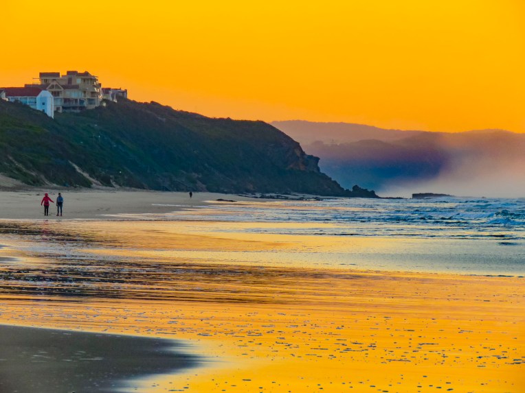 After breakfast we backtracked on N2 to the pullover above the Kaaimans River Railway Bridge. For railroad enthusiasts this was a destination for many years to watch the Outeniqua Choo Tjoe, the last continually operating steam train in Africa, cross the tidal estuary which slowed settlers’ advance along the rugged coast. The line stopped operating in 2006 when landslides destroyed an extensive stretch of track. Today it’s an interesting photo-op.
 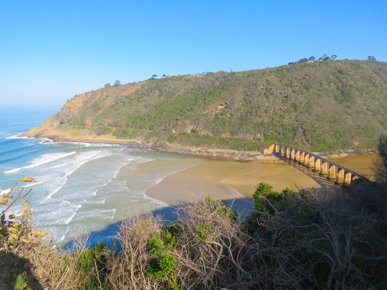 Further up the gorge at Map of Africa View Point, raging waters over the eons have eroded a bend in the river to resemble the African continent when viewed from the overlook on the opposite side of the chasm. The sky was empty mid-week, but across the road hundreds of paragliders launch from the grassy slope on the weekends to catch fantastic thermals and awesome views of the coast below.


SANParks Woodville Big Tree, off the fittingly named Seven Passes Road, was our next stop, to of course visit the appropriately cited Big Tree. A shaded trail led us deep into the Knysna forest to a more than 800-year-old yellow wood that towered 108ft into the canopy, with a 10ft diameter trunk and a 115ft wide crown. Few of these majestic giants remain, having been over-harvested in the past for their valuable hardwood which was used for ship building, furniture making and construction.  After spending hours rattling along dusty back roads we rejoiced to be on Route 2 again. A little while later we pulled over and enjoyed a late lunch and sunny afternoon on the outdoor deck of the Cruise Café, which overlooked Knysna Bay.
  We weren’t yet synched to the rhythm of life outside of Cape Town in the off-season and were surprised to find the restaurants and grocery stores in Plettenberg Bay closed when we arrived. Fortunately, we had a wonderful room with an ocean and lagoon view terrace, right on Lookout Beach, at Milkwood Manor. We were in luck, we had wine and snacks with us, so we had a picnic on the balcony, watching the high tide come in and lift small boats from their sandy berth while darkness fell.
  The sun rose quickly the next morning from behind the Tsitsikamma Mountains, across the bay, filling our room with light. We spent the early morning slowly sipping coffee and savoring the view. Upon checkout we were delighted to find a sparkling clean car. This was a wonderful service the hotel provided for guests, and an easy way for the gardener to earn some extra money.
 We kept to a strict schedule, and limited our stops for photos today, because we needed to be at Schotia Safaris Private Game Reserve just outside of Port Elizabeth after lunch for an afternoon game drive. We chose Schotia for their proximity to Addo Elephant National Park and its herd of 600+ elephants, which is second only to Kruger for elephant viewing. Unlike the parks in east Africa where you can drive cross country in the pursuit of wildlife, the national parks in Africa restrict all tours to the roads. But at the Schotia reserve, with a guide, we would have the opportunity for some overlanding to get closer to the animals, during morning, afternoon and evening game drives over the next three days.
 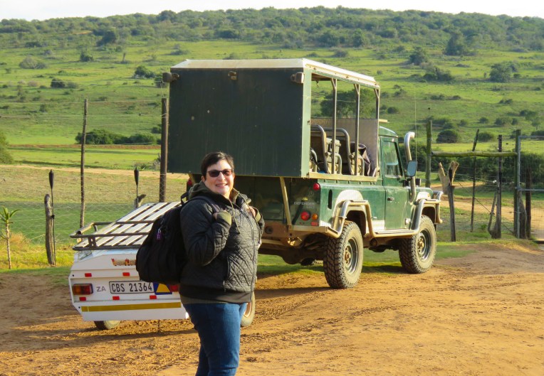 Three guides and three open-sided 4×4 Toyota safari trucks, each capable of seating 16 people, were waiting for their respective groups at the reserve’s headquarters. Wonderfully, it was mid-week in the off-season, and we had Edward, our guide/naturalist, and truck all to ourselves, while the other two trucks left with groups of six each. Schotia’s 4,000 acres of gently rolling hills, bush and forest shelter approximately 2,000 animals from 40 mammal species and its’s amazing how difficult it can be to find them.
  But that was our goal as we rattled along the rutted paths to a high vantage point within the reserve, that provided distant views of the terrain surrounding us. Scanning the vista with binoculars, Edward was searching for elephants, giraffes, antelopes and zebra. “The animals are constantly on the move. We’re never really sure where they will be,” Edward offered. He seconded with, “There’s clouds of dust being kicked up over there. Can’t tell from here what they are, but let’s go investigate.” And our overlanding began, chasing a cloud of dust that turned out to be a small herd of white faced Blesbok, a stunning antelope species we weren’t familiar with.


A few minutes later the reserve’s massive bull elephant the “Boss” rambled up the track toward us and came within touching distance as we quietly sat in awe!  Sightings of impala, kudu, wildebeest, warthogs, cape buffalo, zebra, hippos and crocodiles rounded out the afternoon.


After snacks and a short rest at the reserve’s traditional lapa, a thatched roof structure supported on wooden poles, we headed out into the twilight for an evening game drive to spot some lions on the prowl. 
Hard to spot during the day, lions are even more difficult to find at dusk. The three teams and guides spread out in different directions while staying in touch with their walkie-talkies to share information. The radios were quiet for quite a while until a lioness was spotted hunting in some grasslands on the other side of the reserve. The last blue of the twilight sky was almost gone when we joined the other groups watching the lioness eat her fresh kill in the semidarkness.  On the way back to the lapa we encountered the hippos we had seen earlier, now grazing far from their waterhole. Large black masses, they were barely visible when out of the headlights.
 Glasses of wine and a large, warming fire greeted us when we returned to the lapa for dinner. Inland the temperature fell quickly, and the warmth from the flames felt good.
We hadn’t realized when we planned this road trip, but tonight was the first anniversary of a year on the road. No home, just two suitcases and each other – oh dear.
Dusty after a full day of game drives, we were sitting on the porch of a small cottage sipping wine in the middle of a private game reserve, in South Africa, reminiscing about our first nomadic year.
“It’s hell, I tell you!” My heart sank, but I quickly burst into laughter when I saw a wry smile across Donna’s face as she finished her complaint. “I only have three pairs of shoes with me.”
 Darkness covered the countryside early in June, the beginning of South Africa’s winter season. Our guide had just lit the oil lamps a few minutes earlier, handed us a walkie-talkie and said, “Use this to call the owner if there’s an emergency, you’re the only folks here tonight.’’ The owner lived somewhere on the other side of this vast reserve. There were no other lights around except for the moon. The bush has a life of its own and sounds totally different in the darkness.
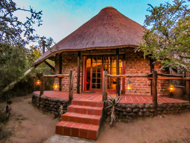 We didn’t plan on being the only folks at the game reserve during the middle of the week, but that’s one of the benefits of off-season travel. Following spring-like conditions around the globe, we’ve been able to avoid hot, humid weather and the crowds, while managing to have some wonderful experiences along the way. Tomorrow, Edward would guide us through Addo Elephant National Park.
 The eastern cape was once home to tremendous herds of elephant which were hunted by the Xhosa and the Khoe (Khoi) tribes for sustenance, and much like the American Plains Indians and buffalo it did not end well. As colonization spread across the region in the 1700 and 1800s the tribes succumbed to smallpox and were pushed into different regions, and the elephants were slaughtered to near extinction for their ivory and to protect farming interests in the region. With the killing of 1400 elephants in 1919, public opinion slowly turned. Only eleven elephants remained when Addo Park was established in 1931 with 5600 acres.
  The park was enclosed with an elephant proof fence in 1954, to protect the surrounding citrus farms from their rampages, when the size of the herd had rebounded to 22 elephants. Today the park is the third largest in South Africa and encompasses 1,700,000 acres. Home to over 600 elephants now, the reserve has expanded its mission to protect a growing number of mammal species within its borders.
 We could have done a self-drive tour through Addo, but we thoroughly enjoyed Edward’s knowledge of wildlife and the region. It was a good decision. Sitting up high in an SUV provided better visibility into the bush, where in our small rental car we wouldn’t have been able to see much. And his timing was perfect in getting us to a waterhole just as a very large herd with calves was creating a trail of dust as it emerged from the surrounding dry bush.
 We witnessed elephants smiling as they drank. It was a tremendous experience.
Till next time,
Craig & Donna


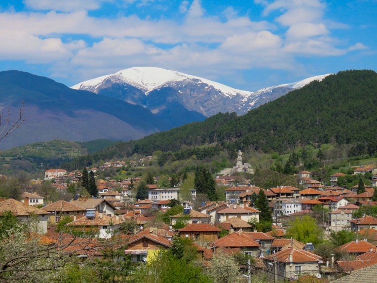 Heading north on Routes 64 and 6 we drove past fallow farmlands waiting for their Spring tilling, and forgotten industrial sites as we worked our way north towards Stara Planina, the Balkans Mountain range that runs east to west for 348 miles and divides Bulgarian into northern and southern regions.


 Turning down the long driveway of the
 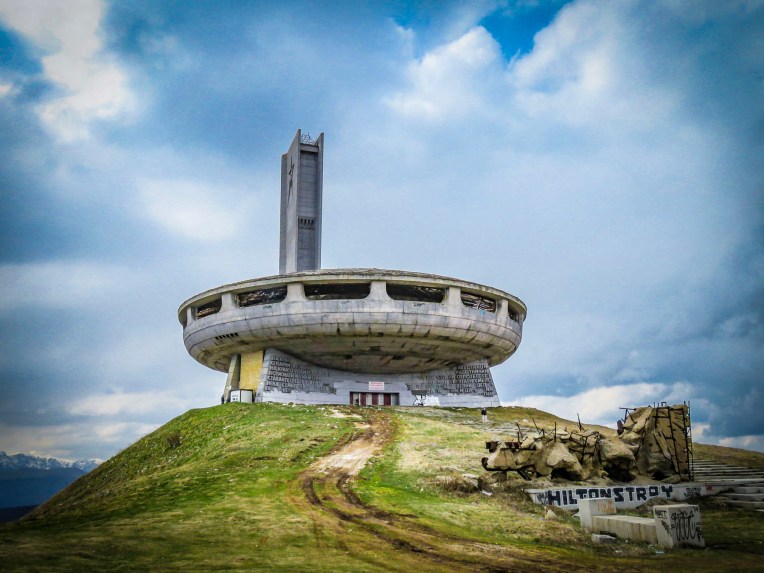 On a wintry, cloudy afternoon the silhouette of

 At the opening ceremony in 1981, tribute was paid to those who had gathered there ninety years earlier. “Let the work of sacred and pure love that was started by those before us never fall into disrepair.” Buzludzha was a huge success and a point of national pride for eight years, hosting communist party congresses and educational events. Schools and businesses booked tours for their students and employees. Foreign delegations were paraded through to witness socialism’s success. But then in 1989 the Berlin Wall fell and communism collapsed like a fighter jet breaking through the sound barrier. The monument to socialism was suddenly ironic, irrelevant and abandoned. In 1999 the security guards protecting it were removed and the building was left open to the public and it was looted. Anything of value quickly disappeared, and the rest was left to vandals and frustrated citizens who were known to take their anger out on the building with sledgehammers or spray paint. The red stars in the tower were shattered by gun shots. Soon the glass skylights broke and water damage from rain and the winter elements hastened its structural decline, and the building was eventually shut tight to protect folks from injury. The day we visited there was a lone security guard, suffering as he made his rounds in the bitter wind, protecting this crumbling modern ruin from a handful of visitors.

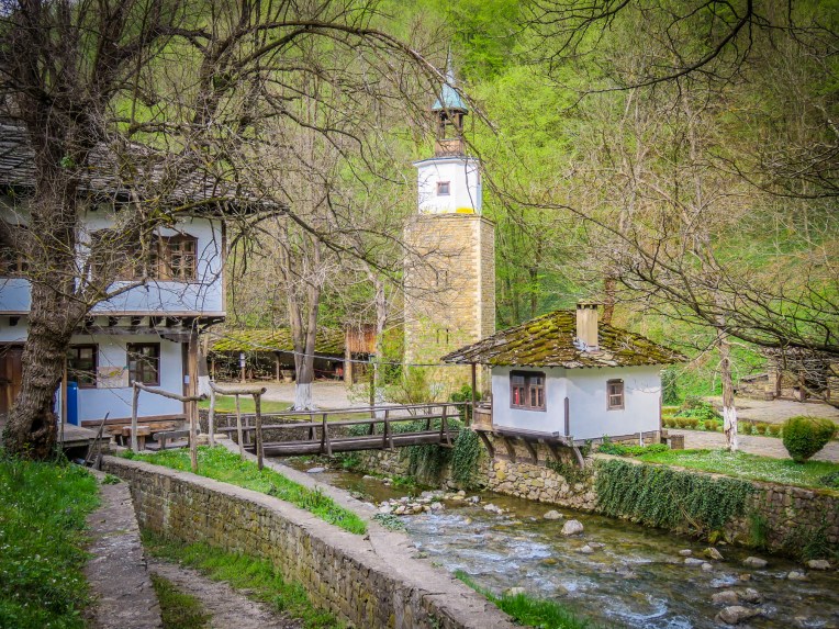 As we continued our journey north through the mountains on Route E85, the picturesque
  Woodcarvers, weavers and other craftspeople dressed in period outfits helped further to transport us to a simpler era at the beginning of the Bulgarian industrial revolution. We visited on a quiet day, but the museum has an extensive twelve-month calendar of events with many festivals listed that would have been nice to observe.
  Traveling along an isolated background road we worked our way towards Sokolski Monastery, known for its cliffside chapel overlooking the northern slope of the Balkan Mountain range. We weren’t disappointed; the church is stunning with its colorful exterior frescoes contrasting with the natural environment surrounding it.
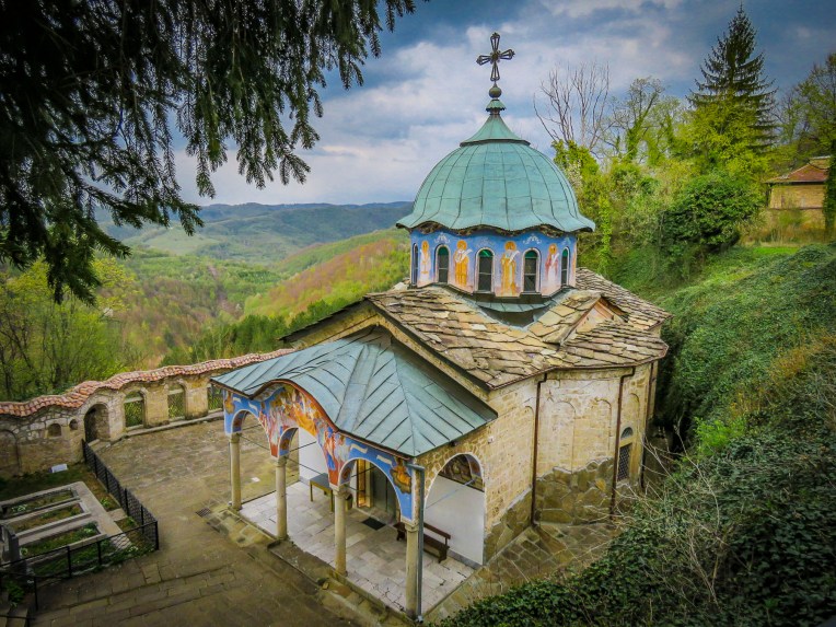 Built in 1833, the monastery has played an important role in Bulgarian history. During the April Uprising of 1876 eight freedom fighters took sanctuary there. Later captured by the Ottoman army, they were thrown to their deaths from the cliff behind the chapel. The short-lived April Rebellion was brutally repressed, but a year later Russia would help the Bulgarian rebels defeat the Turks at Shipka Pass and begin the march towards freedom. In the courtyard of the monastery an octagon-shaped water fountain was built with eight spouts to commemorate those fallen heroes. Legend states the fountain has never run dry and its cool water holds healing powers.
  We made it to Tryavna just in time to have dinner at the restaurant next to our hotel. Enjoying a hot meal after a long chilly day, we were entertained by the waitress trying to keep a determined stray cat from entering the restaurant every time the front door was opened.
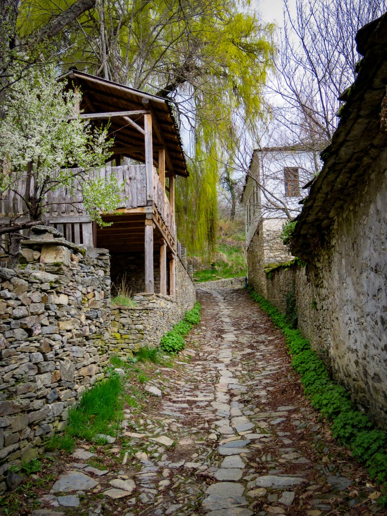
 Generations of skilled woodworkers have lived in the Tryavna River Valley, turning trees harvested from the deciduous forests on the slopes of the Balkan Mountains into furniture and ornate wood carvings.

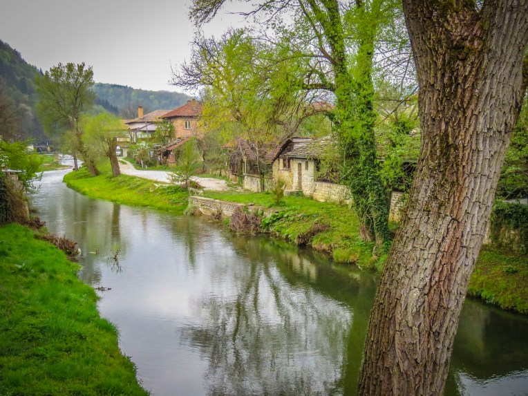 Crossing the footbridge over the Tryavna River at the clock-tower, the pleasant whiff of wood smoke came to us on a chilly Spring morning. Large woodpiles are essential in this region and we saw plenty of homes with the winter’s firewood neatly stacked, as we wandered around the village, with its parks filled with sculpture and tulips in bloom.


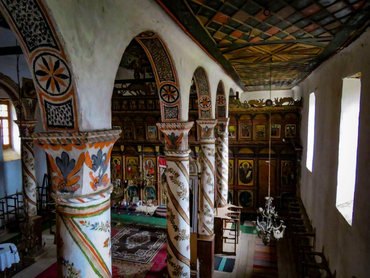
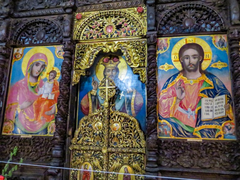 Over the centuries Saint Archangel Michael Church has been reconstructed several times. Its most recent incarnation dates from 1853 when the tall wooden belfry was added. Inside, the interior is richly ornamented with elaborate 19th century woodcarvings and iconography created by members of the Vitan family, famous throughout Bulgaria for generations of skilled artisans. The carved bishop’s throne is an exquisite masterpiece.
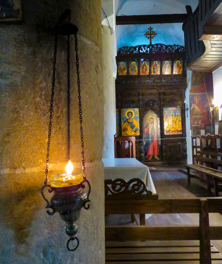 The safest way to order your cup of java in parts of Bulgaria is to ask for a traditional coffee, not wanting to offend anyone by calling it Turkish. The fact is Greek, Albanian, Bosnian, Persian, Turkish andthe same, plus or minus cardamom or a local spice. But here in Tryavna at the Renaissance Café the coffee was brewed on a very traditional sand stove. A shallow pan filled with sand was heated over an open flame, and a long handled, brass cezve was filled with coffee and water, then partially buried in the hot sand to brew. With diligent attendance our coffee was brought to a frothy boil three times before being moved to the top of the sand where it stayed warm while the grounds settled. The ritual of the event definitely enhanced our enjoyment of the brew.
 We only just scratched the surface of this lovely country. There’s so much to see here, especially in its vast countryside. Hopefully one day we’ll get a chance to return.

 Just outside Old Town Plovdiv,


 At just over a mile long the pedestrian mall in the center of Plovdiv is the longest in Europe, running from the Stefan Stambolov Square along Knyaz Alexander I, and Rayko Daskalov Street before ending at the footbridge lined with shopping stalls that crosses the Maritza River.


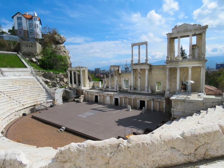
 But the jewel of the mall area was the curved ruins of the Ancient Stadium of Philipopolis, with its fourteen tier seating area, unearthed in 1923. Situated below street level and surrounded by modern buildings at Dzhumaya Square, the ruins provided a dramatic juxtaposition of the ancient and contemporary, where you can actually see the layering of history and how the city was built over earlier civilizations. From this excavated section, archeologists have determined that the stadium was a huge 790 feet long and 165 feet wide and could seat nearly 30,000 spectators.
 Across the square the Dzhumaya Mosque is the main Friday Mosque for Muslims in Plovdiv. Constructed in 1421, it replaced an earlier mosque built in 1363 on the foundations of a Bulgarian Church destroyed during the Ottoman conquest. It is one of the oldest and largest Muslim religious buildings in the Balkans. At the café in front of it we enjoyed some sweet Turkish tea and pastries in the warm afternoon sun.


 After you crouch to enter through a low door and then look up in this intimate space, the WOW element of

 Our main destination was


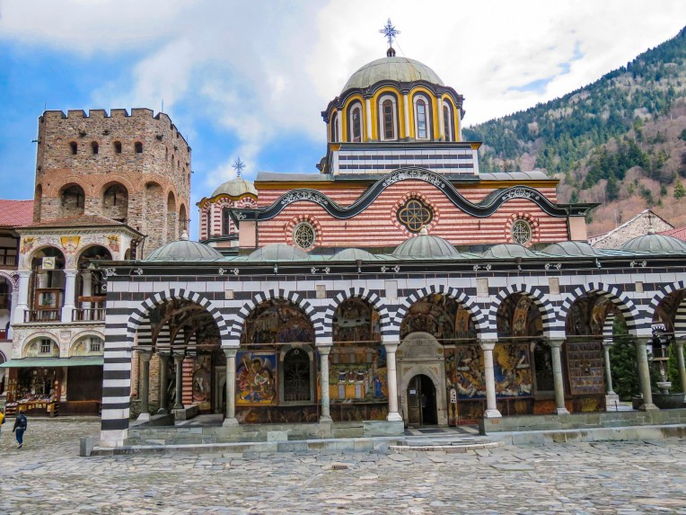 This is the only monastery to survive during the centuries of Ottoman domination over Bulgaria, when it was rebuilt in defiance of the Turks. The Bulgarian people have great affection for this monastery, as a symbol of their religion and culture during those turbulent centuries.
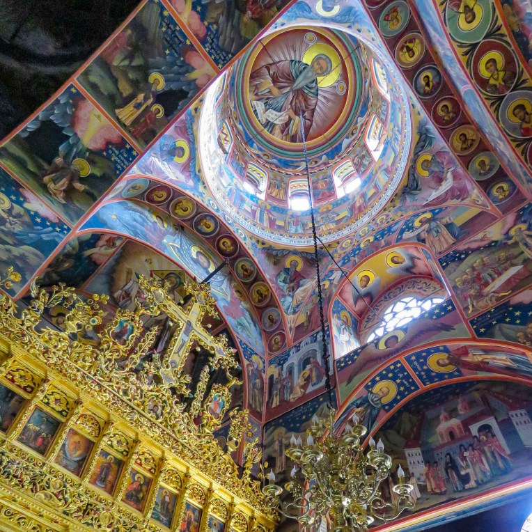


 Thirteen miles from the monastery, on a side street in the town of Rila, we spotted a church with three small cupolas, that called for a quick stop. The church “St. Nicholas the Wonderworker Mirikliyski” was a surprising find with its cracked bell tower and muraled covered entrance porch, complete with woodpile.
 The painter of these hell fire and brimstone murals might have gotten his inspiration from the tortured works of Dutch painter Hieronymus Bosch. Unfortunately, the church was closed and we haven’t been able to find any other information about this off-the beaten-path treasure.


 The Unofficial Junk Museum is a vast, rusty and dusty collection of whatever the owner deemed representative of Bulgarian culture under communism. Radios, tv’s, typewriters, farming equipment, cars, motorcycles, household items and busts of Stalin are stacked everywhere. It’s fascinating! And of all the places to buy a bottle of homemade


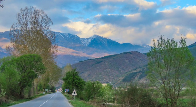
 In the morning we followed Rt. 1 south for a while as it hugged the Struma River, which would eventually reach the Aegean Sea, before we turned off and headed in to the Pirin Mountains.


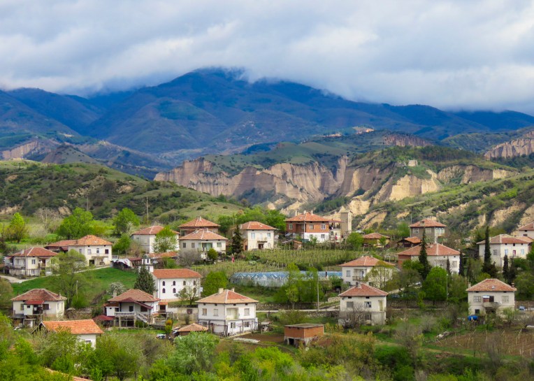
 Melnik is situated in a wide gorge under striking sandstone rock formations, called hoodoos, that tower hundreds of feet high, created from millennia of erosion. Locals refer to these geological phenomena as Melnik Earth Pyramids. The village has been renown for making strong wine since 1346 from a regional red grape varietal, Shiroka Melnishka, and wine cellars still line its main street.
 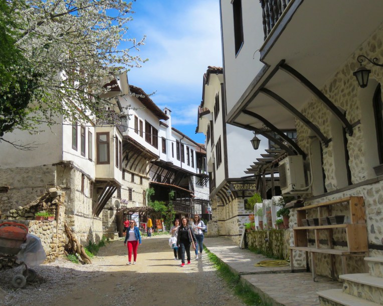 Once a thriving village with one thousand residents, today it is now home to fewer than three hundred. The village was a delight to explore with its cobbled streets meandering between the whitewashed stone and timber homes built in the Bulgarian Revival style. Ninety-six of the village’s houses are historically protected. Any new construction in town adhered to that aesthetic.
  From the ruins of Bolyarska kŭshta, high on a hill above the Church of St. Anthony, we spotted the dome of what looked like a hammam, a Turkish bath, nestled between the traditional homes below, and went to explore.
 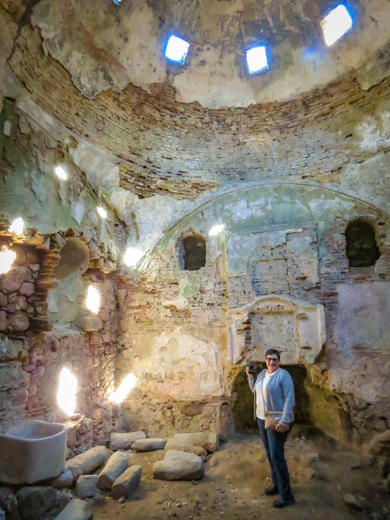 With the help of a kind woman, who somehow knew what we were looking for, we found the ruins of a small Roman era spa in a small side alley. Its dome was fully intact and the substructure of its once heated floor remained. There is also a single arched old roman bridge, near the parking lot, that you can still walk across. Before continuing to Kovachevitsa, we relaxed at one of the sunny cafes in the center of the village.
 Kovachevitsa, an isolated, rustic stone village in the Rhodope mountains, was only 52 miles away near the border with Greece. However, it took us the bulk of the afternoon to reach because “someone stops every hundred yards to take a photo.” And stop we did as we were awed by the beauty of the border region as we drove through the mountains. So close were we to the border that our phones binged with a “Welcome to Greece” message from our cell phone carrier.
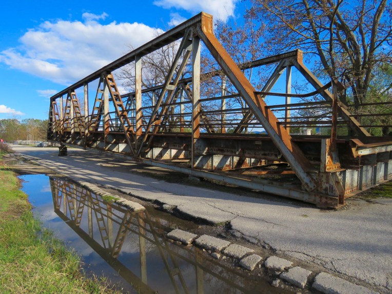 At one point we stopped to photograph a complete section of an iron truss bridge, just rusting away on the side of the road, only to have our car suddenly surrounded by a flock of bah-ing sheep.

 So, we knocked on the ancient door of the closest building only to be greeted by loud barking. Retreating back to the car we pondered what to do when a voice behind us said “hello.” That was the only word of English our host spoke until he said “goodbye” two days later. The barking dog turned out to be a gentle giant, who welcomed us to the inn. In fact, all the dogs of the village were St. Bernard-size, and they must all have been related, because they closely resembled one another. Fortunately, they were good-natured.


 Bulgarians fleeing religious persecution and the forced conversion policies of the Ottoman Empire sought refuge in the rugged Rhodope mountains and established Kovachevitsa in 1656. Agriculture and stockbreeding in the area thrived during the 1800s and the homes still standing in the village date from that time. The tall stone homes of Kovachevitsa are stunning and unique in an organic way.

 At breakfast the next morning Google Translate nicely bridged our communications barrier with the innkeeper’s wife. Loading the Cyrillic keyboard into the app for our hostess to use, Donna’s phone was passed back and forth repeatedly during a lively conversation about family, each other’s lives, the village and our travels. Our hosts’ children live with their grandparents in one of the larger towns off the mountain as there isn’t a school in the village anymore.
 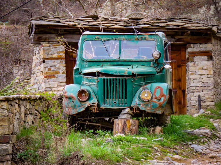 Most of the young families have moved away to find work, leaving only 28 year-round residents looking after the village till the tourist season starts. Strolling under blossoming elderberry trees, we had the narrow lanes to ourselves as we worked our way towards St. Nikolas Church.

 On the way back to our inn we stopped to admire the woolen creations knitted by a lone street vendor with a toothless smile who was bundled under layers of clothing to ward off the mountain chill. Her prospects for a profitable day seemed slim as the street was nearly deserted. When we expressed interest in only one pair of socks, she assertively pantomimed that we needed more. Looking up from readying our payment we could only smile and chuckle when we found she had filled our bag with two extra pairs of socks. They were well made and a bargain, so we caved to her sales pressure. I’m wearing a pair now as I write this, and my toes are happy we she insisted. I wouldn’t have been surprised if we were her only sale of the day.

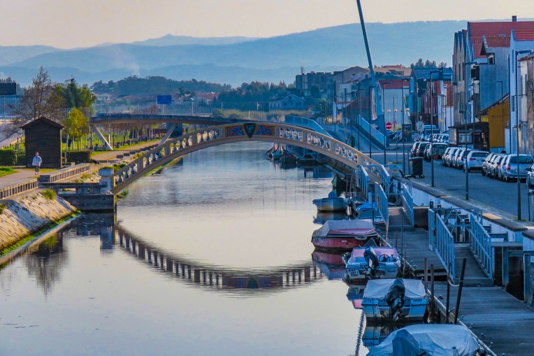
 We had spent a wonderful day cruising from Aveiro to Nazare, but now twilight was fast turning to darkness as we drove along an extremely narrow lane at the base of the formidable fortress wall that encircled Obidos. We had arrived at our hotel
  Admittingly Donna is the more accomplished linguist of the two of us. I according to my loved one have been known to torture a language. So, she eagerly sought advice from the only person we had passed. From a short distance away, I watched the conversation unfold with the gentleman flailing his arms every which way for what seemed an inordinate amount of time.
  Smiling, Donna returned to the car. “About the only thing I got from that was we should continue following the lane until the next hole in the wall. He was very insistent about that.” “Did he know the hotel?” I asked. “Never heard of it, but I think he was intoxicated! My luck,” she laughed. The lane narrowed even more as we drove forward. Finally, there was an ancient portal, the size of a single door, through the wall that led to a short set of steps. Abandoning our car for few minutes we climbed the stairs to an inner lane in search of our hotel. After we finally found the place, the receptionist explained to continue driving along the wall until you reach an old city gate, enter there and follow the inner lane back to us and park anywhere you can. OK, piece of cake now, we thought.
 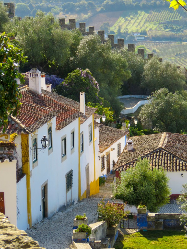 Inhabited since the 4th century BC by the Lusitanos, then the Romans and Visigoths, the city wasn’t fortified until the 8th century by the Moors. Bent entrances, with a quick turn and an additional, heavy inner gate were used in many Arab fortifications. In peacetime they were easy to navigate with pack animals, and during sieges provided a killing zone for the defenders of the city. Remember, these bent gates were built long before cars were envisioned. Obidos had two of them and tonight we had to navigate through one. Porta do Vale ou Senhora da Graça was a drive through chapel dedicated to Our Lady of Grace. In 1727 the old gate was renovated into an oratory chapel with sacristy, altarpiece, gallery, choir, and chancel by a local magistrate to commemorate his daughter’s death. You actually transit through the nave to reach the interior street. The gate was narrow, and it required a sharp k-turn just to line the car up to approach it correctly. Donna was driving and I hopped out to judge just how much room we had around the car. Driving up a slight slope on flagstones worn smooth from centuries of travelers, the tires spun with no traction as the car got halfway through the gate. Backing-up and then gunning the car forward through the gate Donna only had the length of our Fiat 500 to turn sharply right and exit the inner gate. It was do-able but nerve-wracking.


 With only two main lanes that ran the length of village, interconnected by a labyrinth of stairs and smaller alleys, Obidos was the perfect size, only slightly larger than Marvao, to explore for two days and relax before driving back to the airport in Lisbon for our flight to Sofia, Bulgaria.
 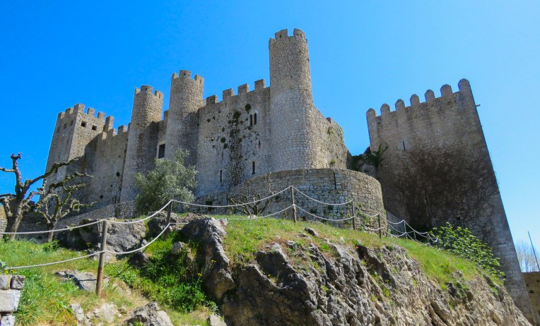 The next morning, enjoying deserted lanes lined with flowering wisteria, calla lilies, and other interesting details we weaved our way to the


 We eventually made our way through the main gate of the walled city. Porta da Vila de Óbidos is another bent entrance that did double duty as a chapel to Nossa Senhora da Piedade, the Virgin Mary, patron of the village. Be sure to look up as you walk through, as Azulejos tiles from the 1700’s line the interior balcony.
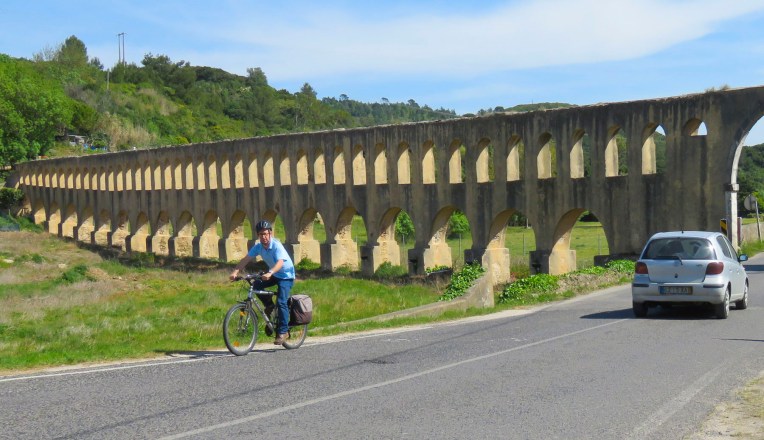
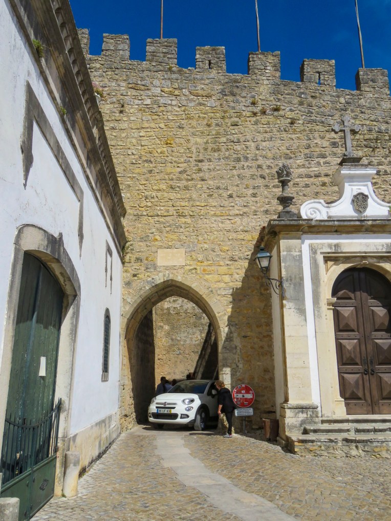 Across the street we walked below remnants of a three-kilometer-long aqueduct built in the 16th century to supply water to the fortress.
  Dinner that night was a simple meal of bread, cheese and local sausages cooked uniquely on a ceramic hibachi, fueled with grappa, placed on our table at Bar Ibn Errik Rex. As flames danced from our mini grill, the waiter would return to our table occasionally and turn the sausages to ensure their perfection. It was an entertaining evening. A few good Portuguese beers helped.
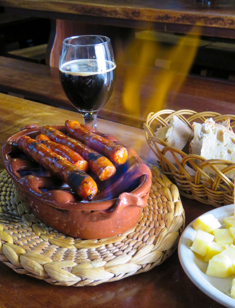 With our GPS App still set to avoid toll roads, we drove through the Porta da Vila de Óbidos and headed towards Lisbon, less than two hours away if we didn’t stop. But, if you’ve been following our blog you’ll know that’s nearly impossible, there is always a quick glimpse of something that calls for a detour.
 Torres Vedras with its aptly named citadel caught our eye. With a historical time-line similar to Obidos, the hilltop in the old historic district was continually fortified against waves of early invaders. Knowing a good piece of real estate when they saw it, the castle was seized during the Christian reconquest in 1148 and used by a succession of Portuguese Kings until it was heavily damaged in the catastrophic 1755 earthquake that hit central Portugal and Lisbon. Built just after the reconquest, Igreja de Santa Maria do Castelo stands just below the castle walls. The church’s bell cast in the 16th century continues to ring today.

 Along the Sizandro River on the outskirts of town, an impressive two-kilometer stretch of a 16th century aqueduct with double arches still stands. Driving under the aqueduct we followed the river south along the R374. The high-density new developments around Torres Vedras quickly gave way to a landscape of vineyards and pastures. Finding a restaurant for a late lunch, though, didn’t seem promising along this rural stretch of road, dotted with the occasional roadside café with a farm tractor parked out front, until we caught a quick peripheral glimpse of a larger establishment, across a small bridge, down a side lane. It would take another mile before we could find a suitable place to perform a U-turn. With nothing else around for miles


 While the Algarve coast in southern Portugal gets the most hype with its azure waters and rock formations, Portugal’s Silver Coast, the Costa de Prata, starting near Lisbon, runs north for nearly 150 uninterrupted miles to the Douro River in Porto. Lightly developed, it’s a majestic stretch of wild, wide and flat sandy beaches and dunes that feels undiscovered and is worthy of further exploration.
 It was mid-afternoon when we arrived at Miradouro do Suberco towering 350 feet above Nazare’s beautiful, crescent shaped Praia da Nazaré beach. Surprisingly, for such a beautiful spot we were able to find free parking nearby above the Nazare lighthouse. The only caveat, an ominous sign warning that if our car some how managed to go over the cliff edge we would still be liable for the €25,000 wreckage removal. You definitely need to know where reverse is on the stick shift here! Some of the world’s tallest waves crash onto the rocks in front of the Nazare lighthouse between October and March. Every year in November the Nazare Challenge attracts suicidal, thrill seeking surfers looking to ride the biggest waves. Thousands of onlookers line the hill above the action to watch their death-defying feats. A record 80-foot wave was ridden in 2017 by Brazilian Rodrigo Koxa and outside the competition, in December 2018, a 100-foot tall monster was surfed by Tom Butler of the United Kingdom. We can’t imagine the raw fury of those size waves. Unfortunately, the day we arrived the ocean was calm.


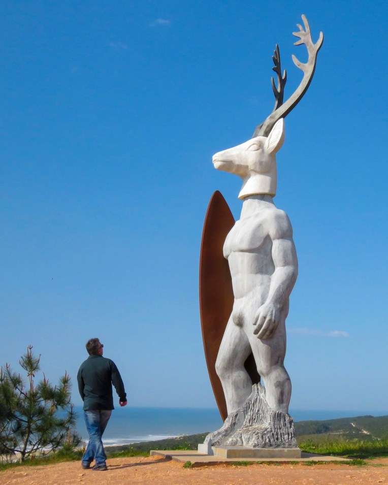 Not far away, just above the Nazare lighthouse, Portuguese artist Adalia Alberto has created a whimsical, deer-headed surfer sculpture called Veado that pays tribute to Nazare’s old legend and today’s legendary wave riders. This contemporary piece has to be one of the most unusual sculptures in Portugal and is worth finding when visiting Nazare.


 We crisscrossed these serpentine estuaries multiple times during the day as we drove through verdant pine forests along roads that hugged the curves of the land. Isolated, whitewashed villages dotted the mountainside.


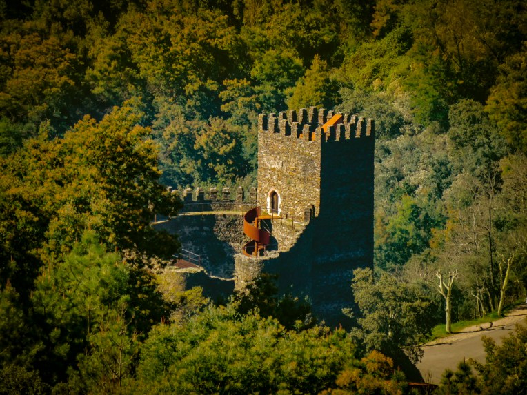


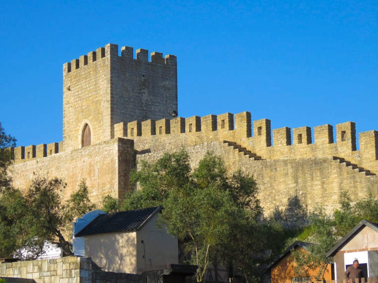
 Fortifying the high ground was the rule centuries ago and the last remnant of Castelo e Muralhas Castelo Branco, the white castle, still commands the skyline above the old historic district of the town. Much isn’t known of the history of Castelo Branco before 1182, when it is first mentioned in a royal document decreeing land to who else, but those prolific castle builders the Knights Templar. Only 18km (11 miles) from the Spanish border, the fortified village quickly grew into an important center of commerce and line of defense to protect the Portuguese frontier. Today only two towers and a wide section of the ramparts are all that remained to remind us of this once mighty fortress and walled city. Igreja de Santa Maria do Castelo is thought to be the first church built in the village, when it was constructed within the castle walls on the foundations of a ruined Roman temple. The church had a turbulent history: destroyed in 1640 during the Portuguese Castile war, burnt down in 1704 and then used by the French as a stable when they invaded. It was left in ruins until it was rebuilt in the 19th century. It now sits peacefully in the park, atop the hill, with a view of the surrounding countryside.


 Monsanto


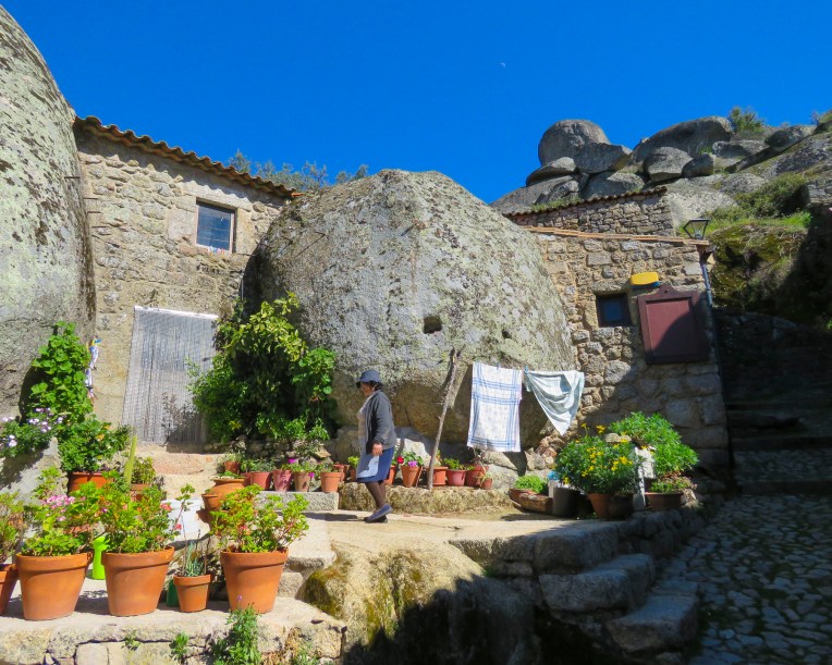 Monsanto


