You’ve landed, rented a car, checked into your hotel. Then what? Where to? It seems the more we’ve traveled and the older we’ve become, the less we plan. Throw a dart at the map? Often, how blue the sky is is the determining factor. That can be tricky in Tenerife where the weather changes quickly multiple times a day. But when in doubt, choose a mirador, any mirador. We figured enroute to them we’d pass other wonderful discoveries that would spur us to detour and investigate, rounding out what we saw of the island. Let your adventure around Tenerife begin. Here’s twelve of the miradors and viewpoints we enjoyed.
Mirador Punta del Fraile
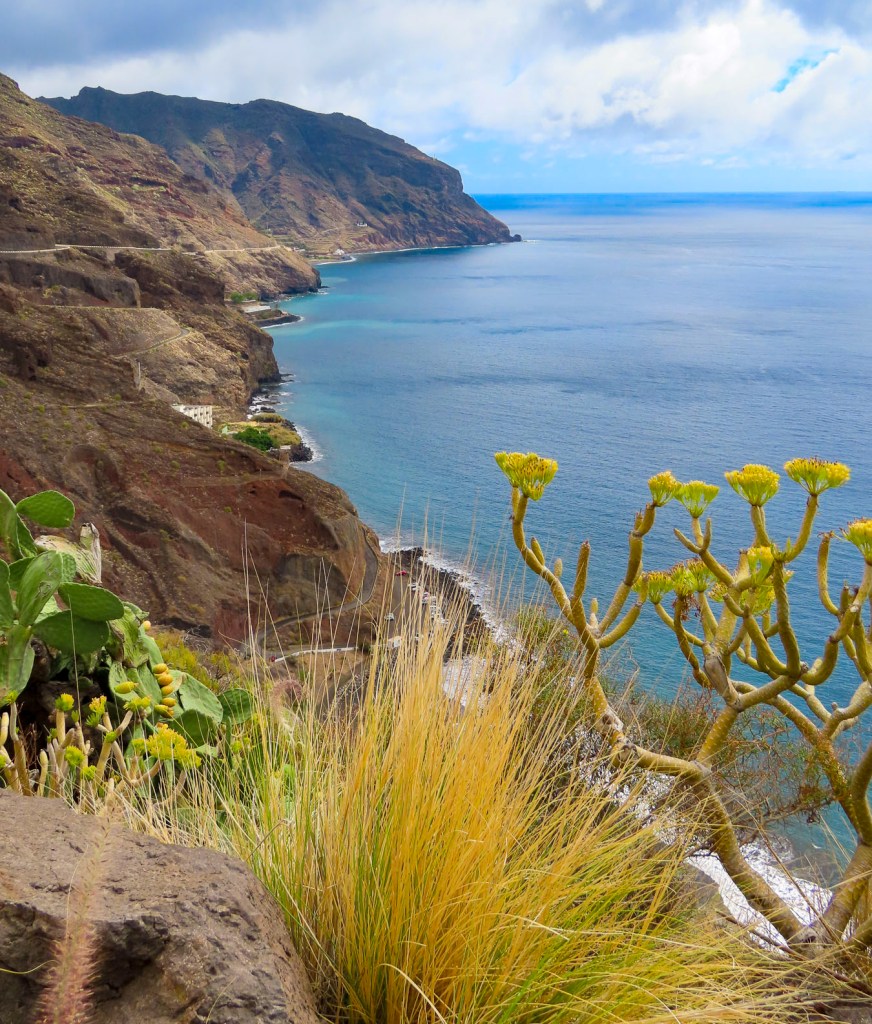
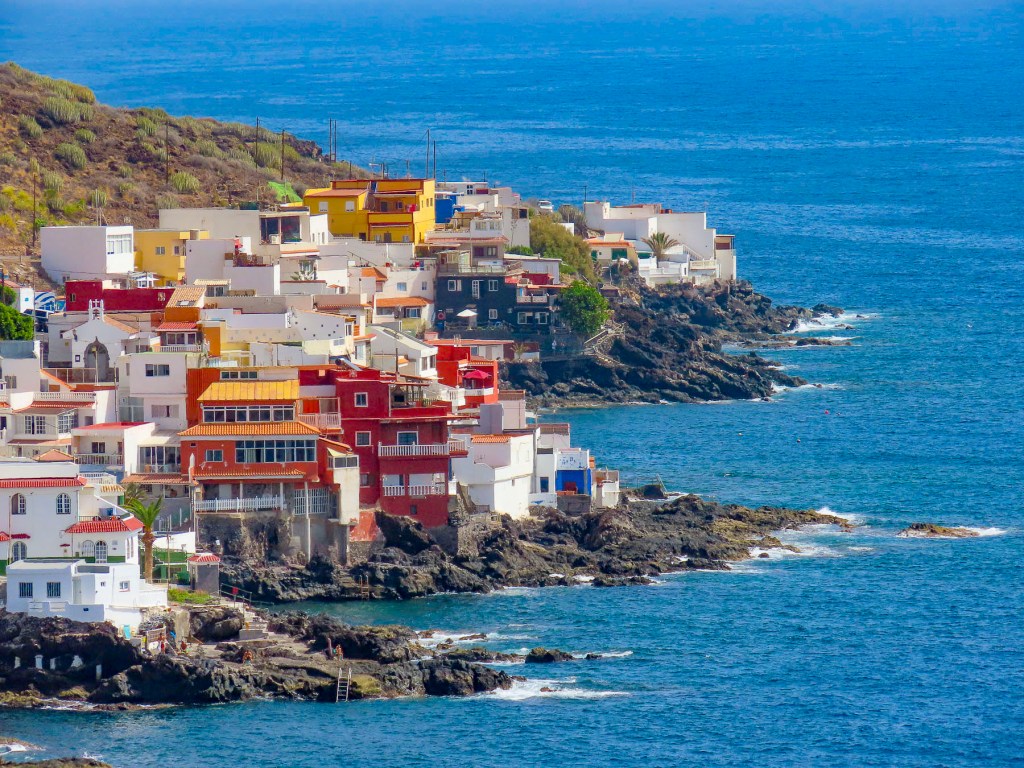
Located on the outskirts of Buenavista del Norte, a manned roadblock across the pavement required us to park. It was about a thirty minute, moderately strenuous uphill walk, and the views along the way were awesome. It was well worth our effort. Reaching the mirador, gale force winds whipped through a cut in the rock which the road followed down to the lighthouse at Punta de Teno, three miles away. Behind us a large cliff face blocked most of the view of the Teno headland.
Nearby Buenavista del Norte is delightful old village with a historic church and memorial to a locust plague in 1659.
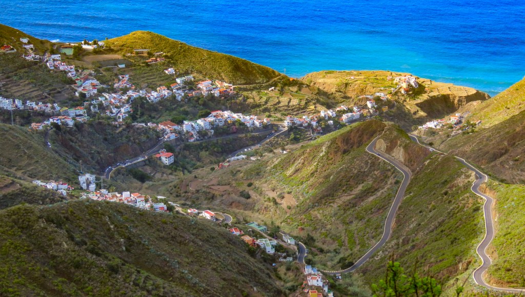
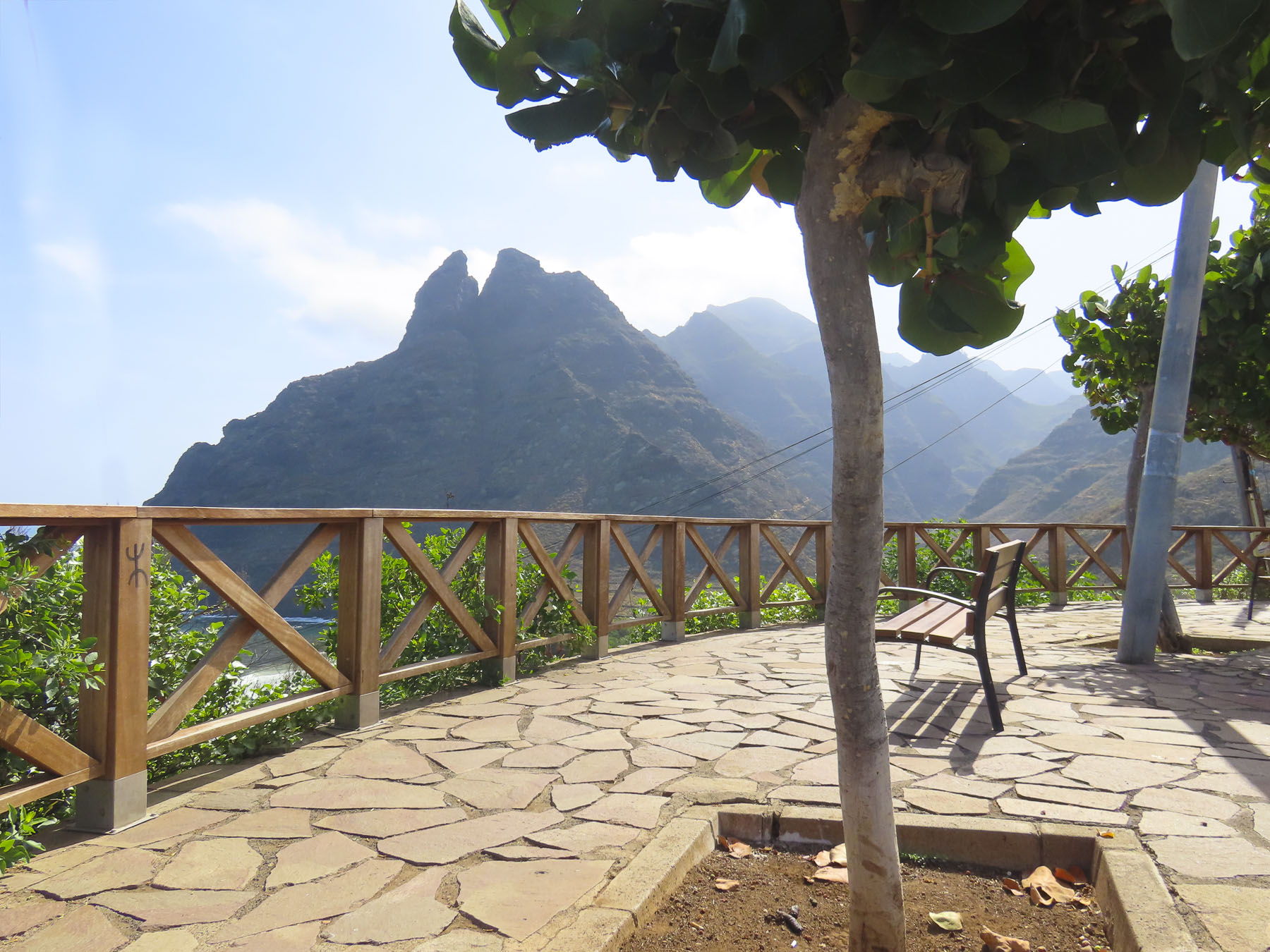
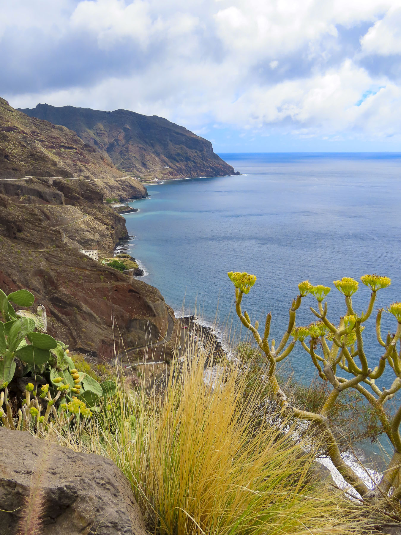
Playa del Roque de las Bodegas & Mirador de Playa Benijo
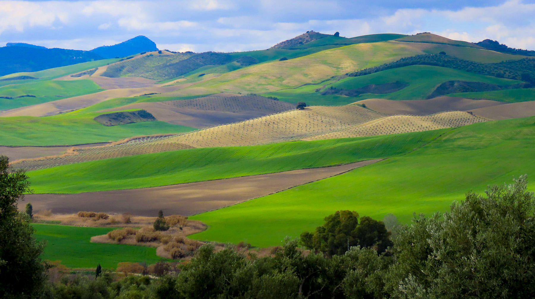
Any resemblance to a straight road disappeared as we turned onto TF-12 to work our way across the island to Playa del Roque de las Bodegas and the Mirador de Playa Benijo. The distances between sites on Tenerife are relatively short as the crow flies, but the roads are narrow and serpentine, so the driving is slow, even though not many cars are on the roads. Rising into the mountains, the terrain changed from arid brown to verdant green. The views along the way of isolated villages hugging the steep slopes were tremendous and there are multiple places you’ll want to stop for photos.
Our intent was to drive all the way to the El Draguillo Mirador, as our GPS map led us to believe it was feasible, but the road ended at a very small gate in a muddy car park with a sign that said only residents of the village were allowed to drive past this point. Evidently this is the starting point for El Draguillo trail, a 6-hour hike.
The parking lot was jammed full, and it took a serious multipoint K turn to get us out. We recovered nicely though by having a great lunch nearby at La Venta de Marrero, a cliffside restaurant with a fabulous view of Playa de Benijo, below.
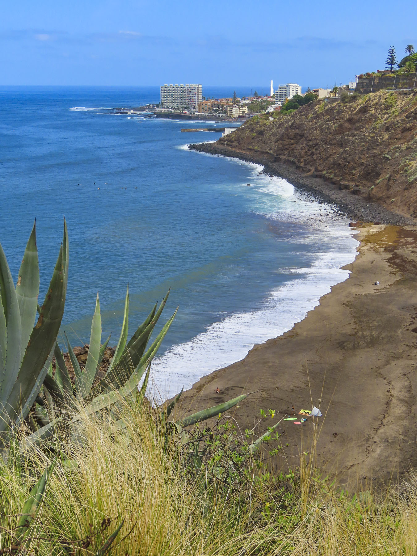
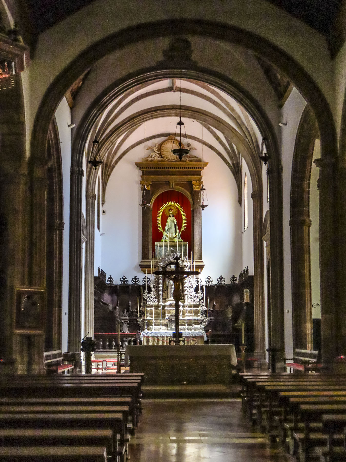
Mirador Playa de las Teresitas
Only twenty minutes from Santa Cruz de Tenerife, the island’s largest city and capital, the Mirador Playa de las Teresitas seems a world away with tremendous views south of the coast.
Turn around and walk a few yards back along the road for a spectacular view of the black sand beaches Playa de Las Gaviotas and Playa Cueva del Agua.
La Barada
Set on a steep hill, the restaurant La Barada, just a short distance off TF-5, is technically not a mirador, but it is a very popular place due to its glass pier that is cantilevered dramatically out over the countryside from the restaurant. It offers an amazing bird’s eye view of the coast with Pico del Teide in the distance. The food was also very good and the terrace was alive with boisterous activity the afternoon we stopped.
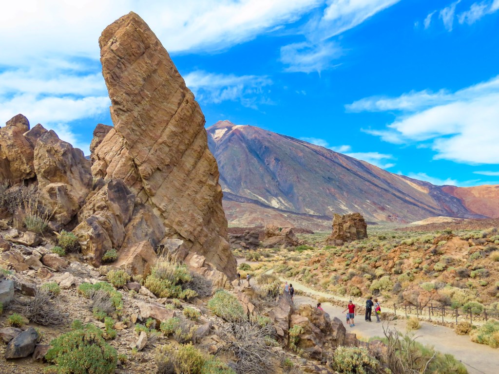
Mirador de Cherfe
Sitting atop a mountain pass, this mirador has expansive views of the sea. It was also one of the busiest miradors, with vendors selling lava trinkets, and many tourists stopping on the way to or from Masca, like us.
Oh, the thrills of driving in the mountains of Tenerife were just beginning!
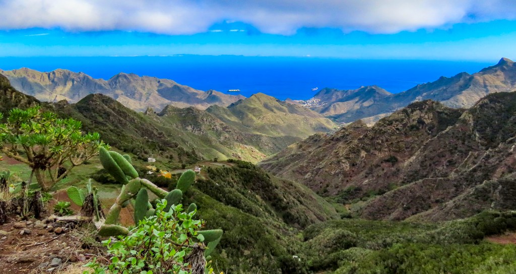
Pico del Teide: Mirador de los Poleos, Mirador de Samara & Mirador de La Ruleta
Venturing into the foothills, our drive continued along TF-38 and traversed ever-changing, diverse bio-systems as we left the arid shrub-covered lowlands behind and climbed into hillsides covered with pine forests. It was a well paved but narrow serpentine road, without any shoulder, that required constant vigilance. The mouths of ancient lava tunnels were visible from the road, but there was no room to pull over and stop for photos until we reached the Mirador de los Poleos.
Beautiful, inhospitable, Death Valley-esque, lunar or Martian, however you choose to describe the varied topography that surrounds Pico del Teide, it’s enthralling and fascinating. So much so that filmmakers have used the location for scenes in several block buster films: One Million Years B.C. – 1966, Planet of the Apes – 1968, Clash of the Titans – 2010 and its 2012 sequel Wrath of the Titans and in 2023 the Last Triala, a Star Wars fan film.
TV episodes of Doctor Who, The Dark Along the Ways and season 2 of The Lord of the Rings: The Rings of Power have incorporated Tiede’s environs into their productions.
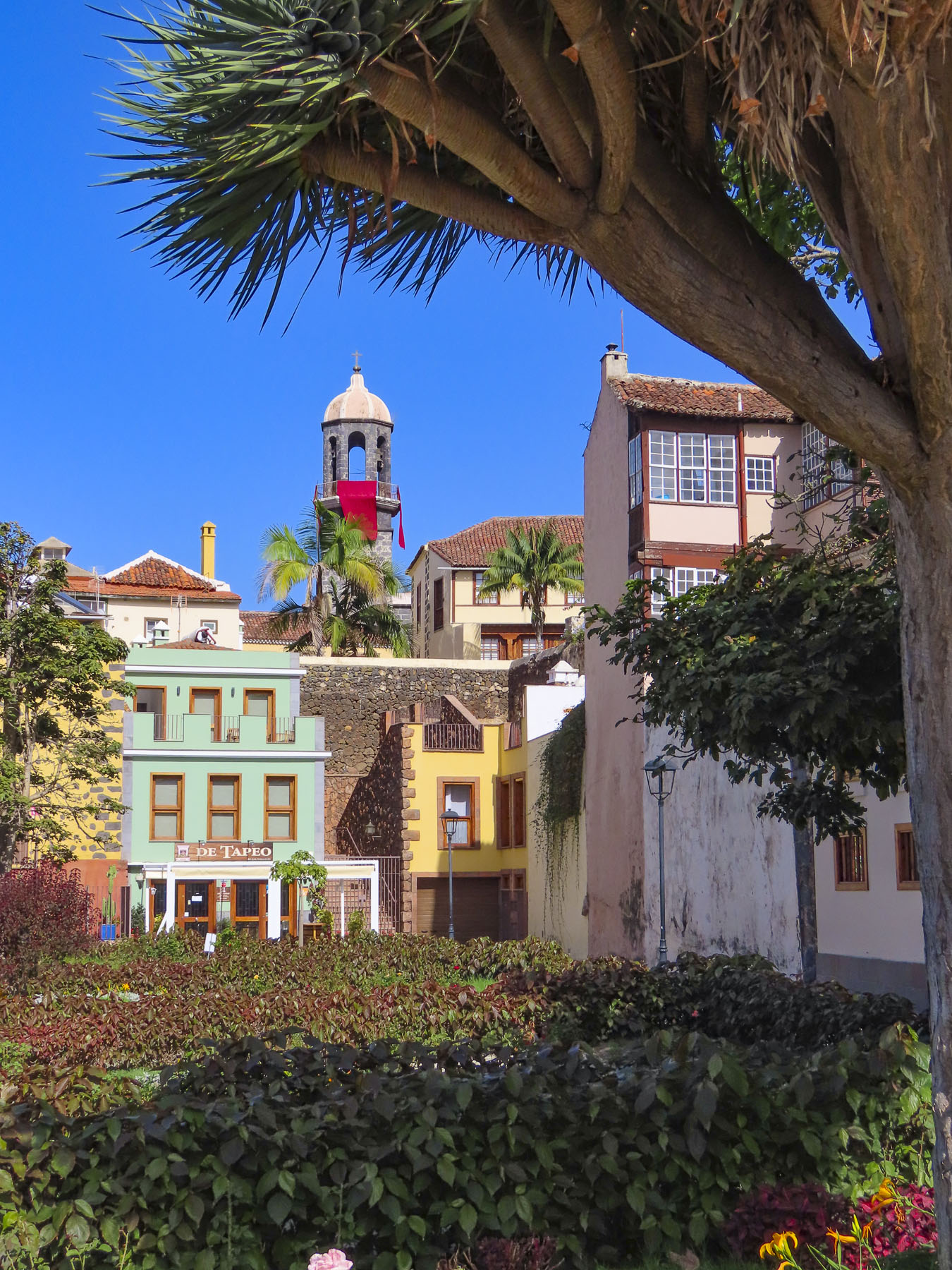
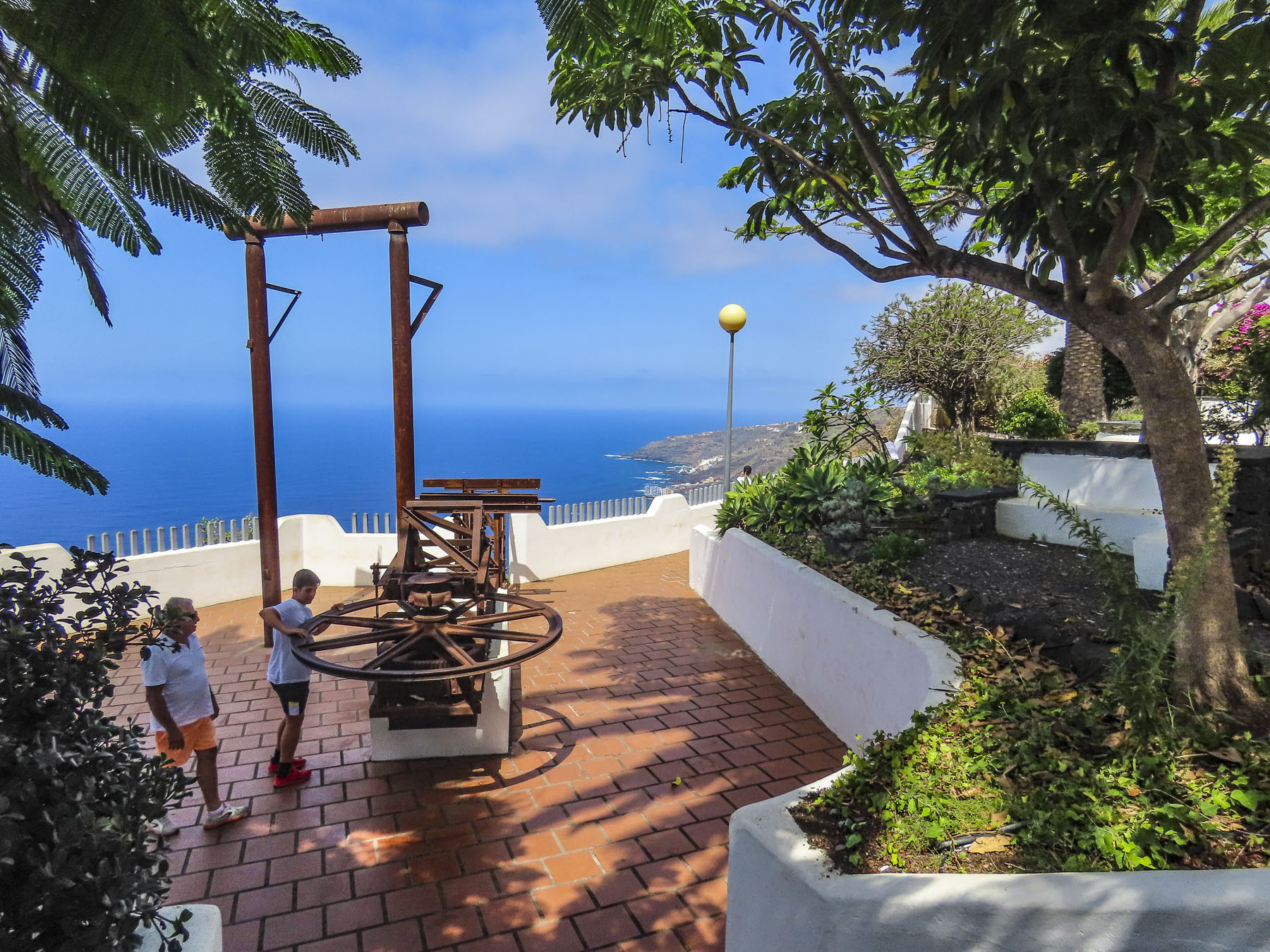
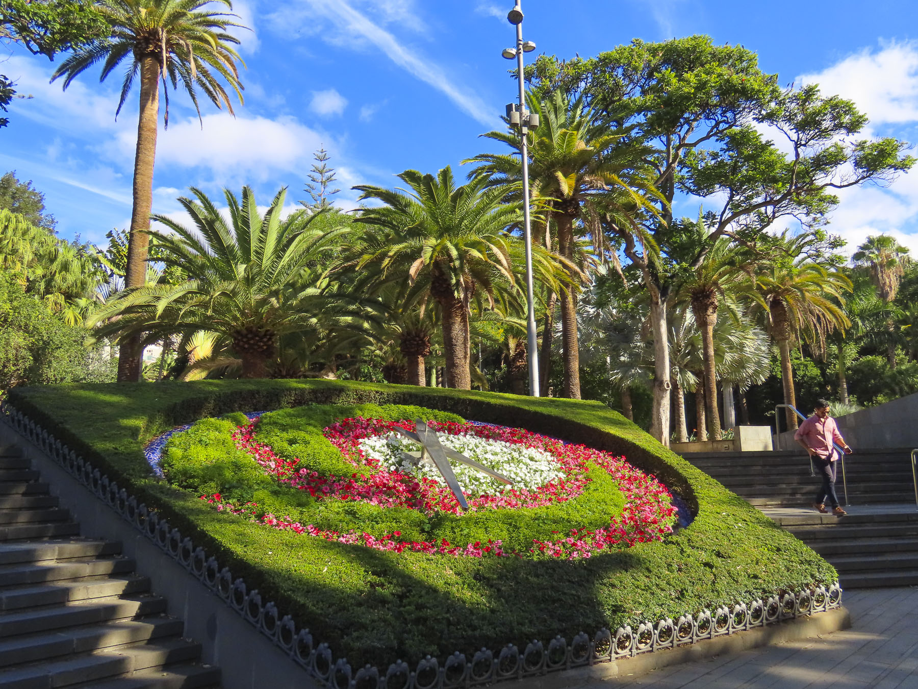
Jardines del Marquesado de la Quinta Roja
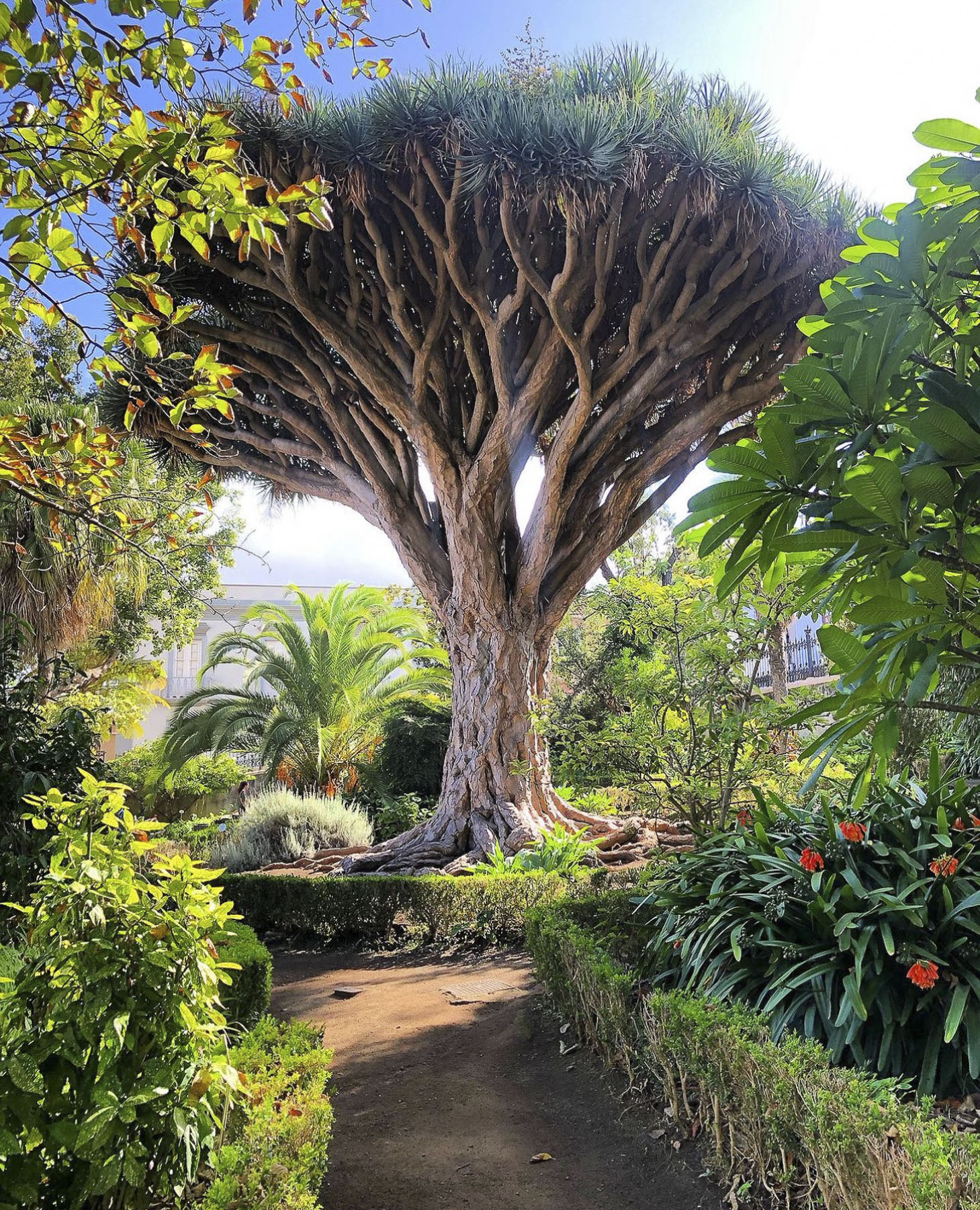
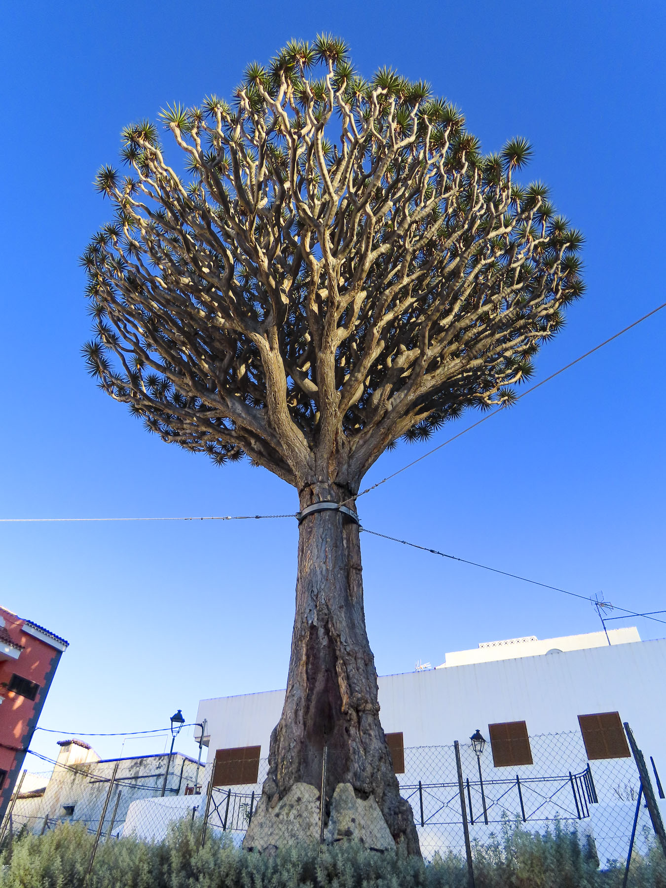
Any visits to La Orotava should start at the Jardines del Marquesado de la Quinta Roja. Constructed in 1883, it’s a beautiful French-style, terraced, formal garden with a view over the town and the distant sea. A smaller but older (1788) sister park next to it, the Hijuela del Botánico, features a towering dragon tree and other plantings of specimen trees collected from Spain’s former colonies. After coffee at the garden’s café, it’s an easy walk downhill in La Orotava’s historic center.
Mirador La Garañona
Is set dramatically atop a 1000ft sheer cliff, in El Sauzal, with a tremendous view of the coast below. The park’s shaded paths lead to a delightful small café perched at the cliff edge. We lingered and soaked in the view.
The Iglesia de Santa Catalina is nearby. It’s a classic, white-washed church from the early 1500s and picture perfect with its magnificent dragon tree in front. Nearby the Restaurante el Calvario is a great place to stop for a delightful meal.
Mirador Roque Grande
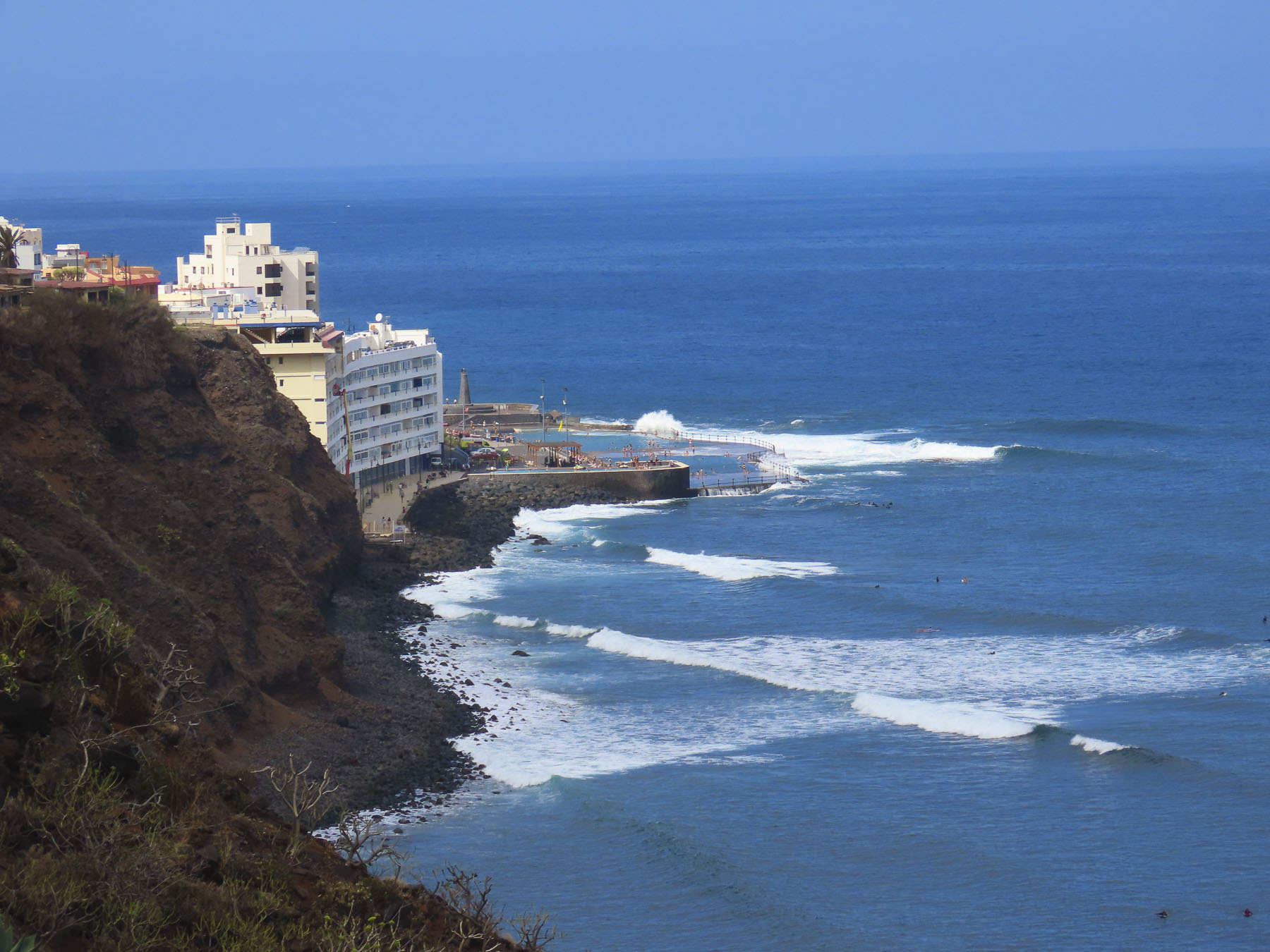
The waterfront in Puerto de la Cruz is beautiful and there are numerous miradors, beaches and tidal pools along the coast where you can swim. We strolled along the promenade above the black sand beaches at Playa Maria Jiménez, and Playa Chica to El Castillo San Felipe, a small block fortress built in the 1600s to prevent pirates or the British from landing on the beach there.
We lunched at a restaurant on the boardwalk under umbrellas just yards from the surf. Stopping at the Mirador Roger Piedra Gorda and Mirador Roque Grande rounded out the afternoon. Though parking was a challenge at both spots, we think the effort was worth it for the dramatic seascapes we viewed.
Mirador del Emigrante
The views driving into Garachico are impressive, and we stopped several times before entering the old town. As prosperous as the Canary Islands are today, we were reminded by the statue at the Mirador del Emigrante that life here was not always easy.
This poetic description by Fernando García Ramos, the sculptor, explains for the viewer the meaning behind his statue of a walking man – with a hole in his chest, as if in his heart – holding a suitcase. “The figure is scanning the horizon, in a daring position, as if pretending to jump over the sea, with a suitcase in hand, and many more suitcases in a series as a chain behind him; these suitcases behind him surely mean the memories, the sadnesses, the nostalgia, the girlfriend, the mother, the sisters, the families that are left behind by an emigrant who takes a new life, who jumps over the infinite sea, in search of a new life in strange and distant lands.”
Mirador Caribe at the Palmetum
Reaching the Mirador Caribe at the Palmetum, we were rewarded with an expansive view of the city and Auditorio de Tenerife. A botanical garden, the Palmetum was started in 1995 atop 30 acres of reclaimed land that was once a landfill. Now it’s filled with nearly a thousand palm trees gathered from around the world. It’s a spectacular place.
Playa del Médano
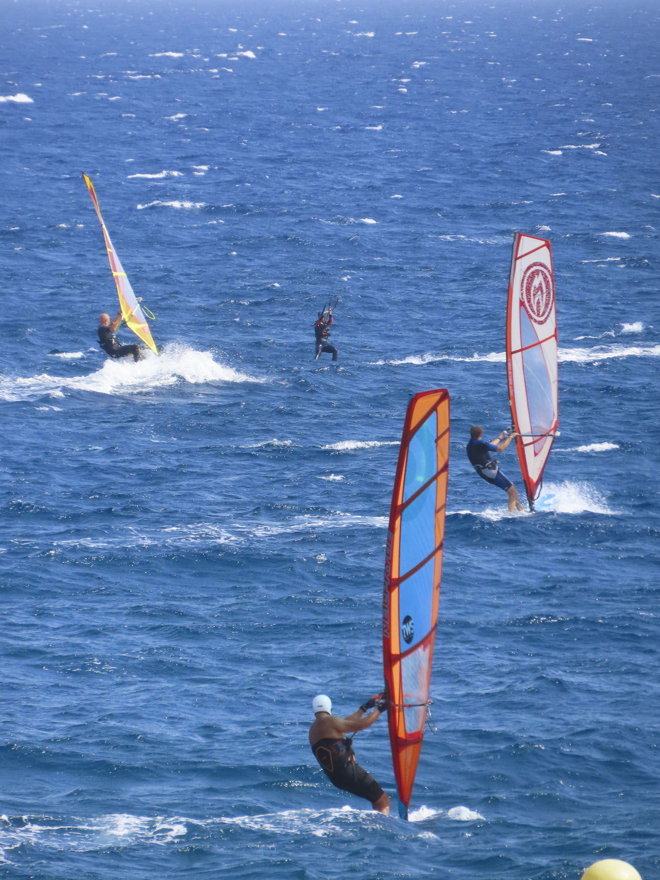
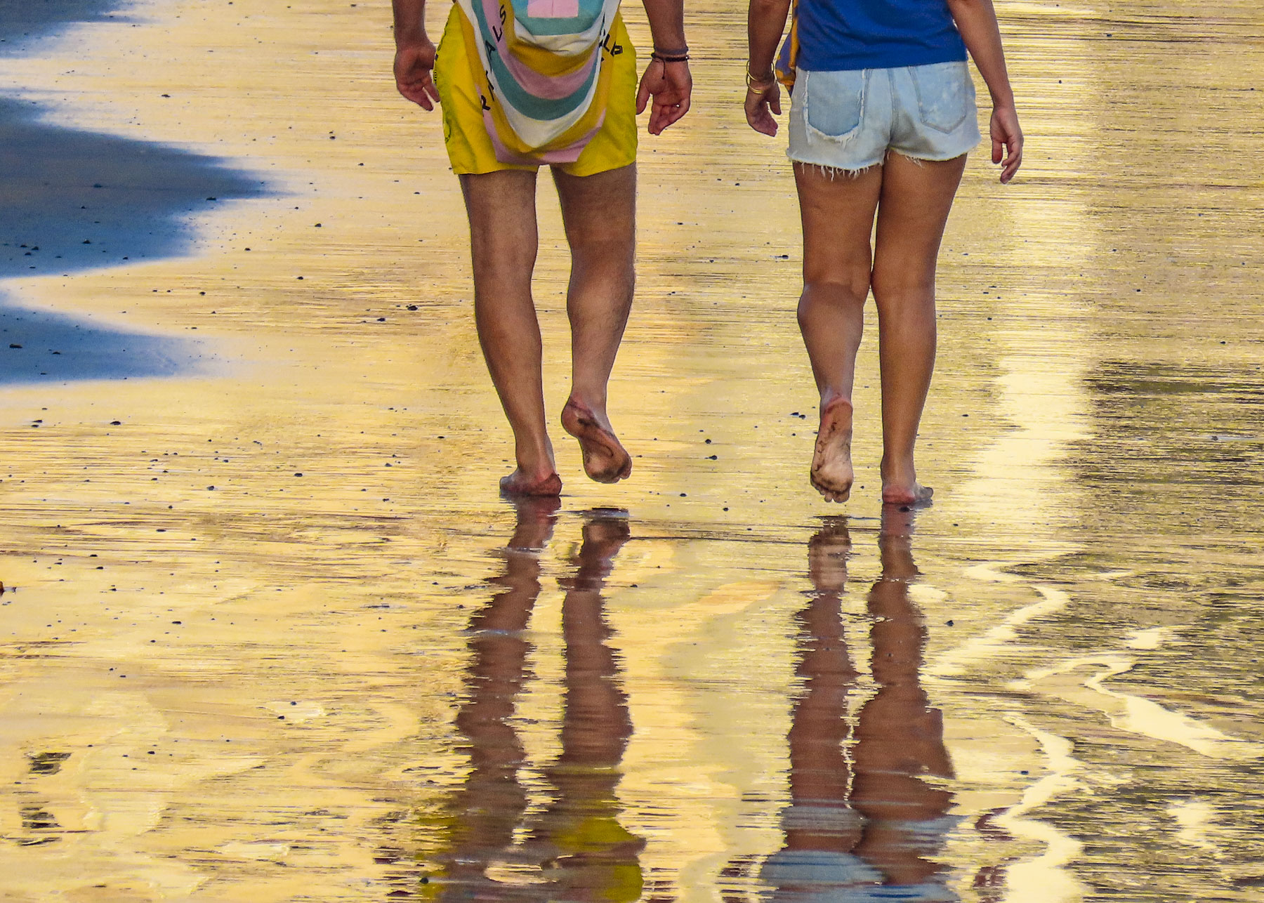
For our last full day on Tenerife we headed to El Médano to be nearer the airport for our flight the following morning. Arriving late in the afternoon to Playa del Medano, we entertained ourselves watching wind and kite surfers speed across the whitecaps. The more experienced kiters crested the waves and performed aerobatics before splashing back into the sea. Closer to town, families favored the gentler waves, wider beach, and a view of Montaña Roja volcano on the horizon. Tables at eateries along the boardwalk were quickly filling as the golden hour approached. A crescent beach, gentle waves, good wine and delicious seafood – is there a better way to end the day? We’ll miss Tenerife.
We hope you found the photos inspirational for planning a trip to Tenerife.
The silhouette of the ancient volcano mesmerized us. Even in the dark blues and blacks of the night the volcano’s majestic silhouette loomed large above Icod de Vinos. Later the moon rose and contributed a magical otherworldliness to our vista. During the winter when its 12,000 ft summit is snow covered and there is a full moon, it’s said to shine like the beacon of a lighthouse that can be seen from the coast of Morocco. The aboriginal Guanches believed Pico del Teide held up the sky and placed offerings on the volcano’s slopes to appease Guayota, an evil deity they believed responsible for its volcanic eruptions. We made our own photographic pilgrimage to Teide as we drove to the Hotel Alhambra in La Orotava, our base for the remainder of our vacation. Though not the most direct route from Icod de los Vino to La Orotava via Pico del Teide it was, I can assure you, the most interesting.
Teide is still considered an active volcano and while its cone hasn’t erupted in the last 850 years, side vents on its slopes have spewed destructive massive lava flows across its slopes in 1492, which Columbus noted in his logbook as he sailed on his maiden voyage of discovery, 1704,1705, 1706, 1798 and 1909. Our route on TF-5 cut across the lava field left from the 1909 El Chinyero vent eruption. Now over one-hundred years later new growth pines are just beginning to emerge from this carnage. Their verdant green needles, a refreshing sign of life in an otherwise barren landscape. Crossing the ridge of the mountains we descended into Santiago del Teide. The main road was lined with several inviting spots to stop for café! (We didn’t realize at the time, but this was also our last chance for lunch, as many places normally open in high season are closed or only open on the weekends in the shoulder seasons.)
After coffee we visited the town’s church, Parroquia de San Fernando Rey. It’s a small, whitewashed structure constructed in the late 1600s and has an interesting collection of religious art. Across the street stands a life-size statue called “the brave Guanche,” dedicated to Alonso Diaz, a goatherd, who in 1509 stood up for his rights and successfully petitioned Spain’s King Fernando the Catholic for justice, after 200 goats were stolen from him by a Spanish conquistador. By royal decree the goats were returned.
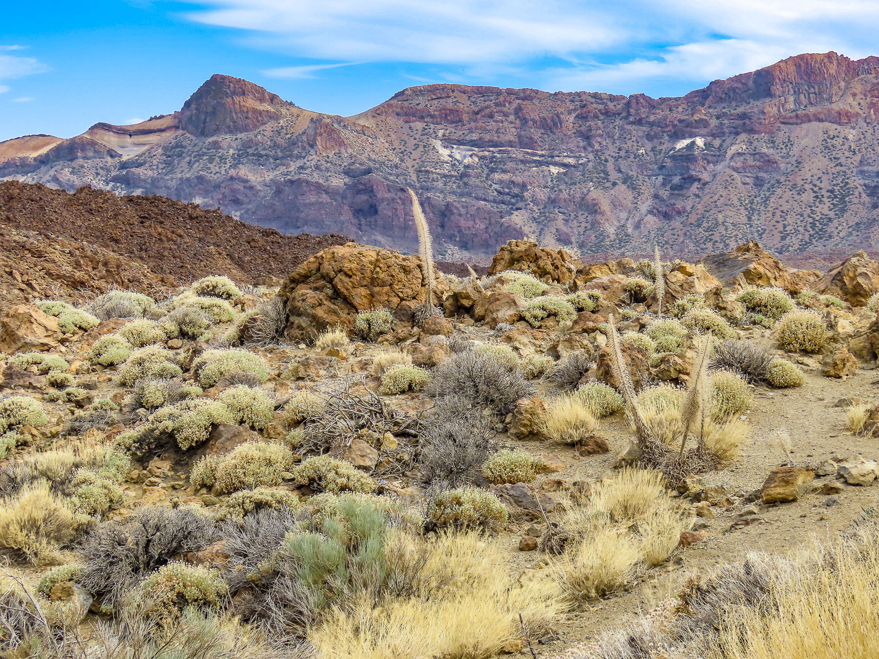
Venturing into the foothills, our drive continued along TF-38 and traversed an ever-changing, diverse bio-system as we left the arid shrub-covered lowlands behind and climbed into hillsides covered with pine forests. It was a well paved but narrow serpentine road, without any shoulder, that required constant vigilance. The mouths of ancient lava tunnels were visible from the road, but there was no room to pull over and stop for photos until we reached the Mirador de los Poleos. Here the raw beauty in these charcoal-colored landscapes flourished beneath the Chinyero Volcano, and we had a chance to walk across the lunar-like terrain, part of the immense lava field from its 1909 eruption. Dotted with huge boulders, it was difficult to comprehend the ferocious forces required to expel these massive rocks from their subterranean origin.
Continuing on, we had encountered what we thought was fog until, to our surprise, we emerged above the clouds at Mirador de Samara.
This area is also very popular for hiking, with many very obvious trails crisscrossing through a young forest emerging from the volcanic soil left from Pico Viejo’s last, 92 days long, eruption in 1798.
Approaching noon, we turned toward Vilaflor, the highest village, at 4600ft, on Pico del Teide’s southern slope and surrounded by vineyards. The surrounding wineries produce some of Tenerife’s best wines from Listán Negro, Malvasia, Negramoll, and Listán Blanco grapes. And are embodied with a distinctive terroir from the warm climate and fertile volcanic soil. The weather had suddenly turned gray and dreary. More frustrating though, the wineries we had planned to visit were closed mid-week during the shoulder season. Fortunately, we happened upon Mar de Nubes, a craft store and café run by a friendly young married couple from Tenerife and the States. The shop features only handicrafts made by Canarians and local wines and artisanal beers. Of course, we shopped.
Beautiful, inhospitable, Death Valley-esque, lunar or Martian, however you choose to describe the varied topography that surrounds Pico del Teide’s, it’s enthralling and fascinating. So much so that filmmakers have used the location for scenes in several block buster films: One Million Years B.C. – 1966, Planet of the Apes – 1968, Clash of the Titans – 2010 and its 2012 sequel Wrath of the Titans, and in 2023 the Last Triala, a Star Wars fan film. TV episodes of Doctor Who, The Dark Along the Ways and season 2 of The Lord of the Rings: The Rings of Power have incorporated Tiede’s environs into their productions.
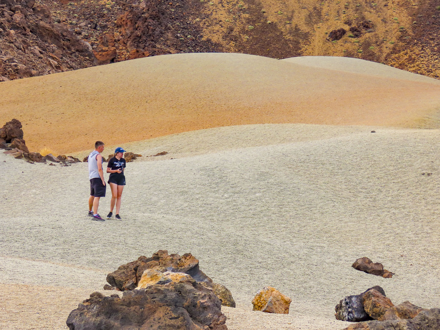
Driving back up the mountain we continued on to view the large sculptural outcroppings at the Mirador de La Ruleta and the desert-like dunes of the Siete Cañadas hiking area, before following the long downward grade of the road to La Orotava. We speculated that if you dropped a soccer ball at the top of the slope, it would bounce downhill continually until it splashed into the ocean at Puerto de la Cruz, roughly 23 miles away. Our route along TF-21 cut through forests ravaged by the wildfires of 2023. The blackened trees were the only scars in the otherwise pristine wilderness of the Tiede’s northern slope in Parque Natural Corona Forestal.
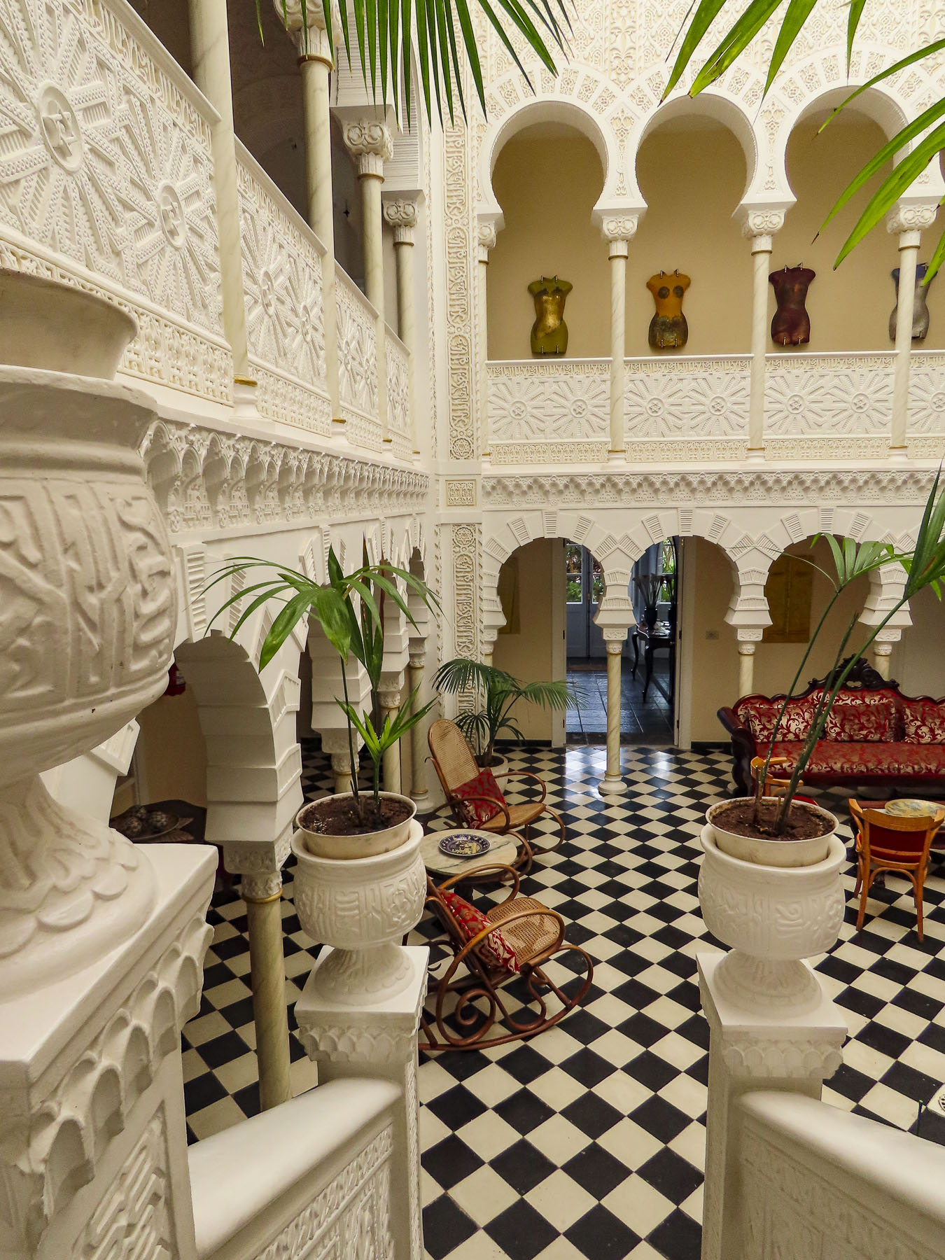
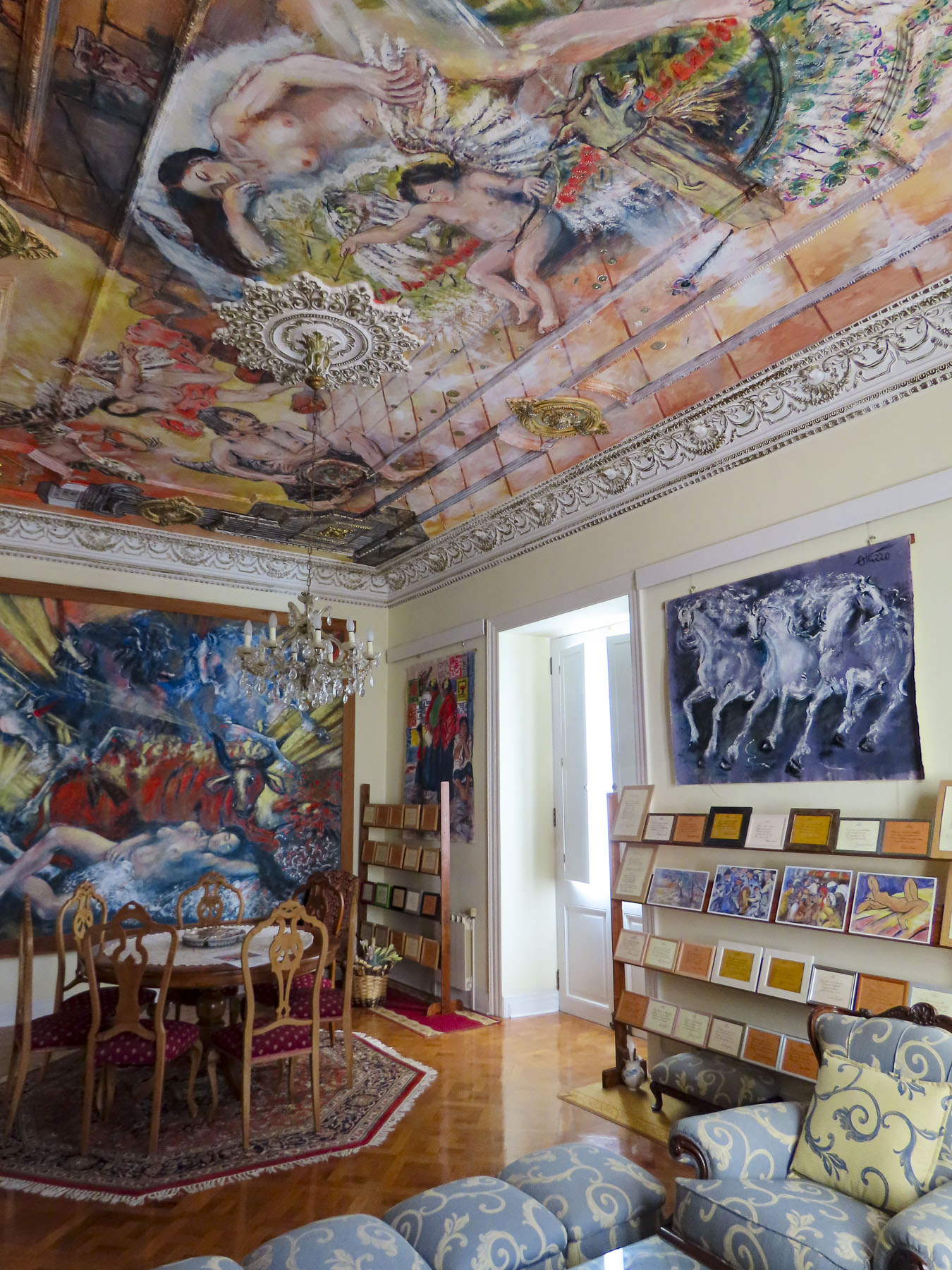
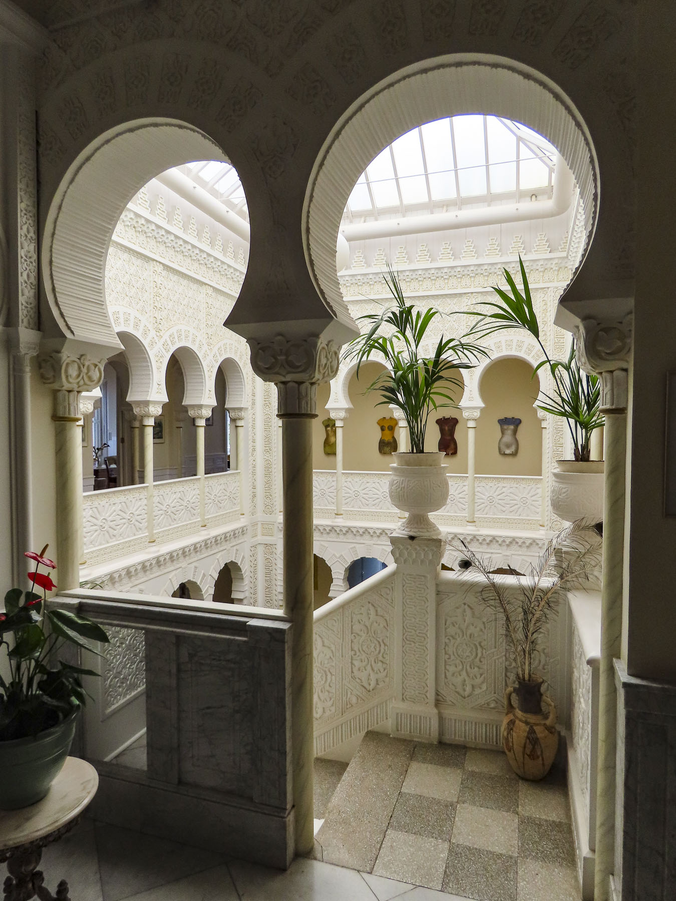
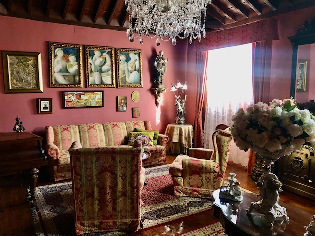
Late in the day we coasted into our parking space in front of Hotel Alhambra. Parking on the streets in La Orotava is free, but it’s a competitive sport. We chose to stay at this hotel for its distinctive architecture and location in the historic center. While the exterior of the 500-year-old dwelling is quietly classical, the interior walls of its Canarian-style courtyard were beautifully transformed in 1925 with intricate floral and geometric Nasrid art designs, created with gebs plasterwork and enclosed under a high glass roof. An eclectic decorating theme is highlighted with frescos by Maestro Antonio Otazzo, a local self-described painter, sculptor, musician, philosopher, and poet. As if being followed by a friendly giant, Pico del Teide was in our line of sight when we opened the shutters on our room’s window.
La Orotava was rather easy to walk around if we were walking across the slope, but after several days our hamstrings and calves were sore, though our butts were firmer. “Walk a little then café,” as we say was the perfect approach to exploring this wonderful town.
Along with San Cristóbal de La Laguna, it’s considered to be one of the prettiest towns on Tenerife.
Getting to the higher points in town we asked the hotel to call for a cab, for a quick ride to the Jardines del Marquesado de la Quinta Roja. Once part of an estate, it’s named after the noble interred in the park’s marble mausoleum; as a member of the Masonic Temple his family was not allowed to bury him in the town’s catholic cemetery. Constructed in 1883, the garden is a beautiful French-style, terraced, formal garden with a view over the town and the distant sea. A smaller but older (1788) sister park next to it, the Hijuela del Botánico, features a towering dragon tree and other plantings of specimen trees collected from Spain’s former colonies. And if you are in awe of dragon trees, as we are, the Villa de La Orotava Dragon Tree Tour might be for you.
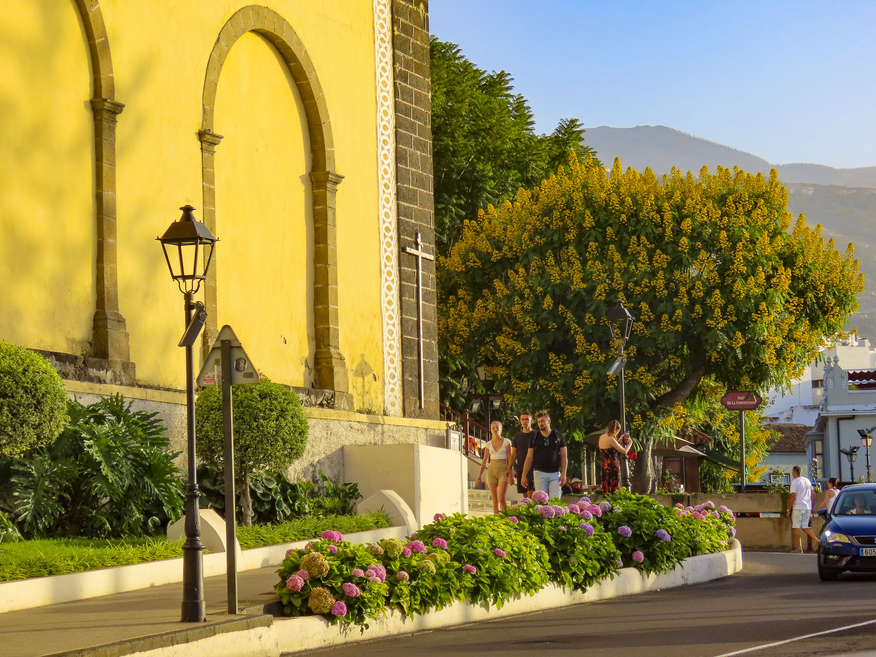
From the gardens we wandered downhill along cobbled lanes, past wonderful examples of colorful Canarian architecture, into the historic old town, which is centered around the Nuestra Señora de la Concepción. Started in 1516, it is the town’s oldest and largest church, with its colorful dome giving the town its iconic skyline.
But La Orotava’s history starts early in 1496 with the final defeat of Tenerife’s aboriginal Guanches at the battle of Aguere, after which their leader committed suicide by jumping off a cliff in nearby Tigaiga. “To the victor go the spoils,” and the fertile lands of the Guanche kingdom of Taoro were awarded to the nobles, conquistadors and financiers who participated in the Spanish victory.
The rich soil of the hillside was perfect for the cultivation of sugarcane and the steep streams from the mountain were soon harnessed to run sugar and lumber mills. Prosperity followed. Ice from Mt. Tiede chilled the drinks of the town’s wealthy.
Landowners and merchants built large family mansions in a style which would become known as Canarian, which feature interior courtyards and distinctive facades with decorative wooden balconies and the family’s Coat of Arms prominently facing the street. Convents housed the daughters from families that didn’t want to diminish their wealth by paying the dowry for the girls’ wedding, as was the custom of the time.
Vines and wine replaced sugar cane and ruled the town’s economy in the 17th century. In the mid-1800s, the textile mills of Europe were searching for different dyes, and mealybugs or cochineal were bred in cactus around La Orotava and harvested to obtain a crimson dye, produced from an acid that the bug makes to fight off predators. Since the late 1800s, vast banana plantations thriving on Tenerife’s mineral-rich volcanic soil continue to bring prosperity to the island and La Orotava, enabling the community to restore its historic buildings.
Not wanting to miss anything on Tenerife, we planned day trips from La Orotava around visiting coastal miradors and following any whims along the way. The Mirador Punta Del Hidalgo was not our favorite photographic destination, but we did enjoy stopping at the crescent shaped, black sand beach at Playa del Arenal in Bajamar, and a farmer’s market, Mercadillo del Agricultor in Tacoronte. Here we purchased some pastries for a snack and some Tuno Indio juice made from the purple fruit of the Canarian Red Prickly Pear. The cactus was brought to the Canary Islands from the Americas centuries ago and has been used in Canarian folk medicine to lower blood sugar and treat other ailments. It also has antiviral, anti-inflammatory, antioxidant, and anti-ulcerogenic properties. It tastes pretty good.
Afterwards we headed to the Mirador La Garañona in El Sauzal. Set dramatically atop a 1000ft sheer cliff, there’s a tremendous view of the coast below. And the park’s shaded paths led to a delightful small café perched at the cliff edge. We lingered and soaked in the view.
On the way to the mirador, we whizzed passed a small neighborhood restaurant set by itself on a corner, and decided to try it on our return trip. But first we had one last stop to make on the way at the Iglesia de Santa Catalina. It’s a classic, white-washed church from the early 1500s and picture perfect with its magnificent dragon tree in front.
Lunch at Restaurante el Calvario was delightful, with excellent house wine and menu featuring traditional Canarian dishes. A young friendly staff, tolerant of our poor Spanish, contributed to a very enjoyable afternoon.
Puerto de la Cruz, just down the hill from La Orotava, was the destination for our last day trip. Originally a small fishing village, the town grew in importance after the main harbor on the north coast of Tenerife in Garachico was filled with lava from a 1706 volcanic eruption. Close to La Orotava, it also benefited from that town’s thriving economy, with the export of sugar, wine and bananas from its port. It has been a popular vacation spot since the Victorian era. Now it attracts visitors and expats from across Europe, drawn to its cosmopolitan vibe, wide beaches, quaint historic center, numerous parks, and vast array of restaurants.
Giant three-hundred-year-old fig trees, planted when the park first opened in the 18th century, are king here. Shaded pathways thread through a cornucopia of verdant jungle, flowers, and water garden. We enviously wished that we could grow everything in our garden at home.
In the historic center we had coffee across from the majestic Iglesia de Nuestra Señora de la Peña de Francia and afterwards were able to catch a glimpse of a bride and groom taking their vows. Their antique wedding car waiting under gently swaying palm trees on the plaza in front of the church.
The waterfront in Puerto de la Cruz is beautiful and there are numerous beaches and tidal pools along the coast where you can swim. We strolled along the promenade above the black sand beaches at Playa Maria Jiménez, and Playa Chica to El Castillo San Felipe, a small block fortress built in the 1600s to prevent pirates or the British from landing on the beach here. We lunched along the boardwalk under umbrellas just yards from the surf.
Stopping at the Mirador Roger Piedra Gorda and Mirador Roque Grande rounded out the afternoon. Though parking was a challenge at both spots, we think the effort was worth it for the dramatic seacapes we viewed.
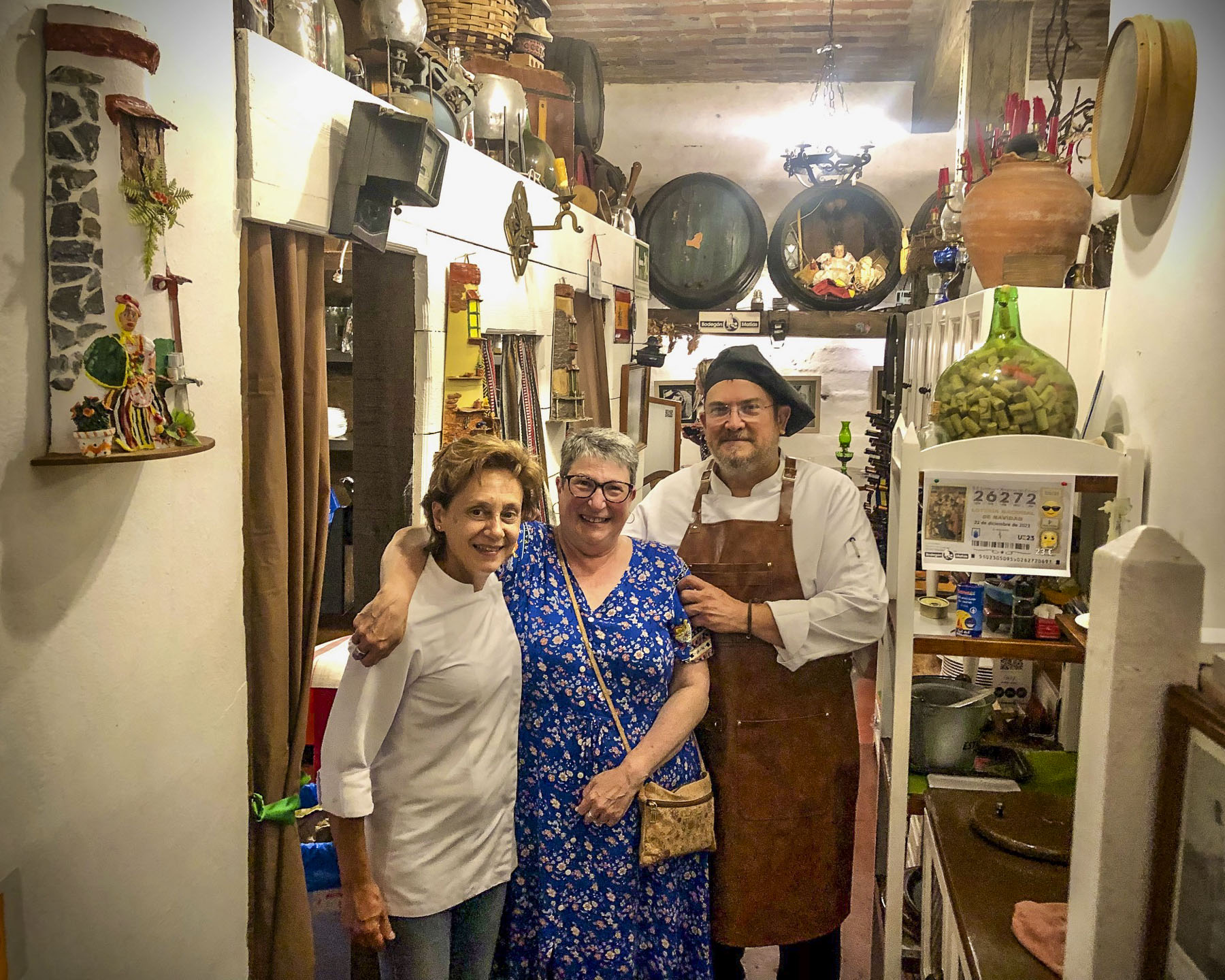
That evening we drove up into the hills above La Orotava and enjoyed a great meal at Bodegón Casa Matías. It’s a rustic establishment, decorated with wine barrels and antique farming tools to acknowledge the history of the region. The chefs and owners, a vivacious husband and wife team, are part of Tenerife’s farm to table movement, sourcing only local meats, including rabbit and goat, fish, cheeses, and seasonal vegetables for their traditional Canarian recipes.
For our last full day on Tenerife, we headed to El Médano to be nearer the airport for a flight the following morning. Arriving late in the afternoon to Playa del Médano we entertained ourselves watching wind and kite surfers speed across the whitecaps. The more experienced kiters crested the waves and performed aerobatics before splashing back into the sea.
Closer to town, families favored the gentler waves, wider beach, and a view of Montaña Roja volcano on the horizon. Tables at eateries along the boardwalk were quickly filling as the golden hour approached.
A crescent beach, gentle waves, good wine and delicious seafood – is there a better way to end the day? We’ll miss Tenerife.
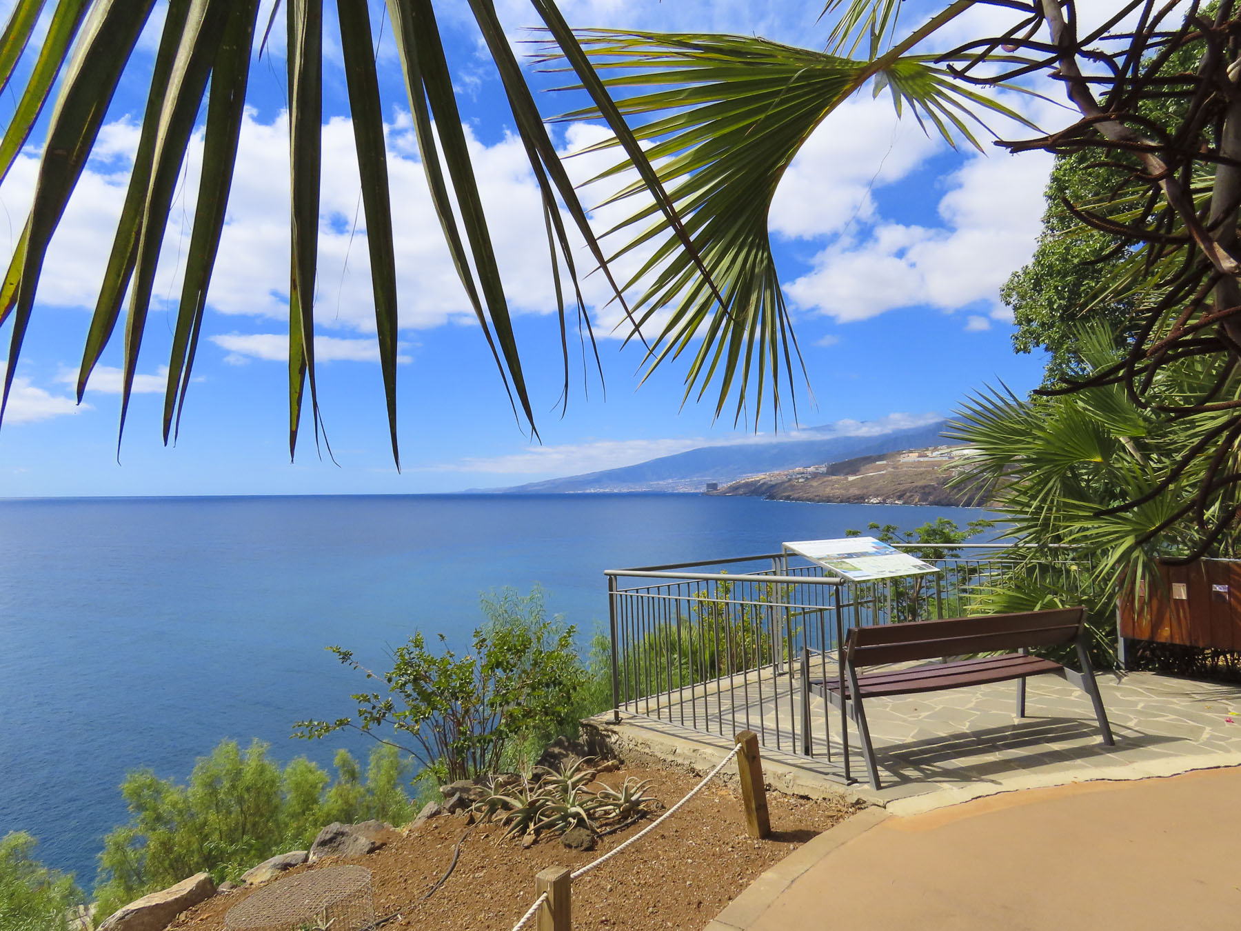
Departing Santa Crux de Tenerife, we drove along the TF-5 towards Icod de los Vinos, our base for the next several days as we explored the lower part of the north side of the island. A compass orientation doesn’t accurately describe how Tenerife is split into north and south regions, but Pico del Teide and its rugged highlands roughly divide the island into the dryer South, which faces Africa and catches the westerly blowing Sharqī, a hot wind from the Sahara, while the North of the island is shielded by Pico del Teide from the hot winds blowing west from Morocco, is wetter from Atlantic Ocean storms.
We are not really resort and beach people; there’s that getting sandy issue that deters us. We do enjoy a close proximity to the ocean and beautiful seascapes, both of which were easily attainable on the north side of Tenerife. We figured that the best way to do this was to chase miradors. And there wasn’t any shortage of them on the island. We figured enroute to them we’d pass other wonderful discoveries that would spur us to detour and investigate, rounding out what we saw of the island.
Set on a steep hill, the restaurant La Barada, just a short distance off the highway, was our first stop. Though technically it’s not a mirador, it is a popular place due to its glass pier that is cantilevered dramatically out over the countryside from the restaurant. It offers an amazing bird’s eye view of the coast with Pico del Teide in the distance. The food was also very good and the terrace was alive with boisterous activity the afternoon we stopped.
We arrived late in the afternoon to our lodging at Hotel Emblemático San Marcos in iIcod de los Vinos. Located on a steep narrow street, it was a challenge to park close to the buildings on the driver’s side and still have enough room to get out of the car, but the parking was free and right in front of our hotel. Built in the early 1700s as a private mansion, it exemplified typical Canarian architecture of the period with its courtyard and meticulously crafted interior, rich with polished wood. The view from our room over the red tiled roofs of Icod extended to the sea.
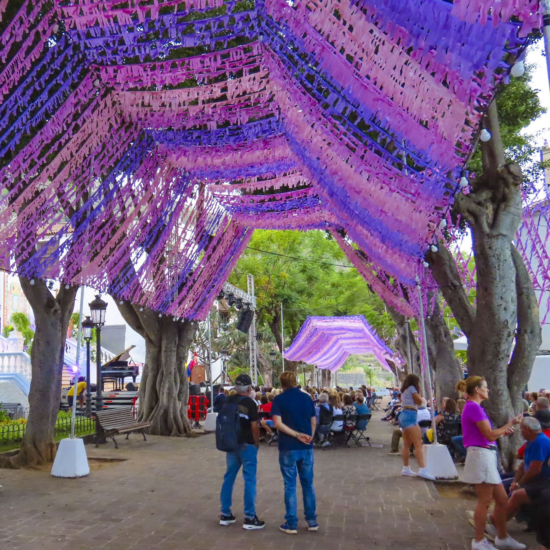
Still early in the evening, we headed uphill to explore the historic center of the town and to our delight happened across an outdoor concert in the festively decorated plaza next to the Iglesia Mayor de San Marcos. The performances were part of the town’s September’s month-long Christ of Calvary celebrations. Legend says that when the conquistadors first landed on the beach here in the late 1400s they discovered a statue of San Marcos awaiting them. A fortuitous omen that promptly required a church be built. A century later the church was beautifully expanded to what it is today.
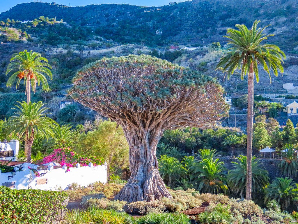
As the evening was darkening, we caught our first glimpse of El Drago Milenario. Believed to be 1000-years-old, it is the largest dragon tree on Tenerife. With over 300 branches, and a circumference of 66 feet, it’s a lofty 70 feet tall.
Beloved by the folks of Icod de los Vinos, the tree’s image is included on the town’s coat-of-arms along with Mount Tiede which also towers over municipality.
In centuries past trees harvested from the mountain’s slopes were sledded down the steep ancient roads of the old town, all the way to the harbor, where prosperous shipbuilders used them in the construction of naval vessels that participated in the ill-fated Spanish Armada of 1588. This unique sledding tradition is still kept alive every November with the La Fiesta de las Tablas, when younger folks speed down Plano Street on tablas, polished planks of wood, that often become airborne with their riders when they hit bumps in the road. Unfortunately, we did not witness this fiesta, but the video clips on YouTube are amazing. The cleared slopes around the town now host orchards, vineyards and banana plantations.
That evening we watched the climax of the festival – a spectacular fireworks display – from the balcony of our room. Throughout the night church bells continued to ring out loudly at odd times with seemingly random numbers of chimes. A curious oddity at the end of a wonderful day.
The weather was brilliant and the next morning we set out to visit the Mariposario del Drago, a large glassed enclosed tropical greenhouse that has a butterfly breeding program. Being gardens we find butterflies very entertaining. The experience here was delightful, and elicited smiles from everyone when a butterfly landed on them.
Across the street from the Mariposario, the El Drago Milenario stands behind a high walled and gated fence. The small admission fee to the park is well worth it to support the town’s effort in keeping this goliath of a tree alive. But, if you’d rather skip the expense and put it towards coffee or lunch, there’s an enticing café named Casa del Drago, with a good view, right next door. Farther uphill along Calle San Antonio there is Drago junior, a magnificent younger dragon tree that, according to legend, the town seized from its owner when he tried to cut it down in a fit of rage.
Fortunately, this part of the historic town center is relatively flat and the walking was easy as we headed back to admire the plaza around the Iglesia Mayor de San Marcos in the daylight and the church’s 16th, 17th, and 18th century religious art.
Afterwards we strolled along the town’s old lanes until we reached city hall and the Iglesia de San Agustin, both of which are dramatically set on a small plaza at the top of a set of ancient stairs. The church dates from the late 1500s and was originally part of the first convent built in the town by the order of Los Augustinos.
The road to Playa de San Marcos in the harbor of Icod is spectacular with views of the coast. It was here, in this sheltered bay, one the few natural harbors on Tenerife’s north coast, that the Saint’s venerated statue was discovered in a cave along the cove.
We found it best to just find a place to park and then walk to the vantage point that interested us. During the September shoulder season when we visited, tourists were scarce and finding parking was relatively easy.
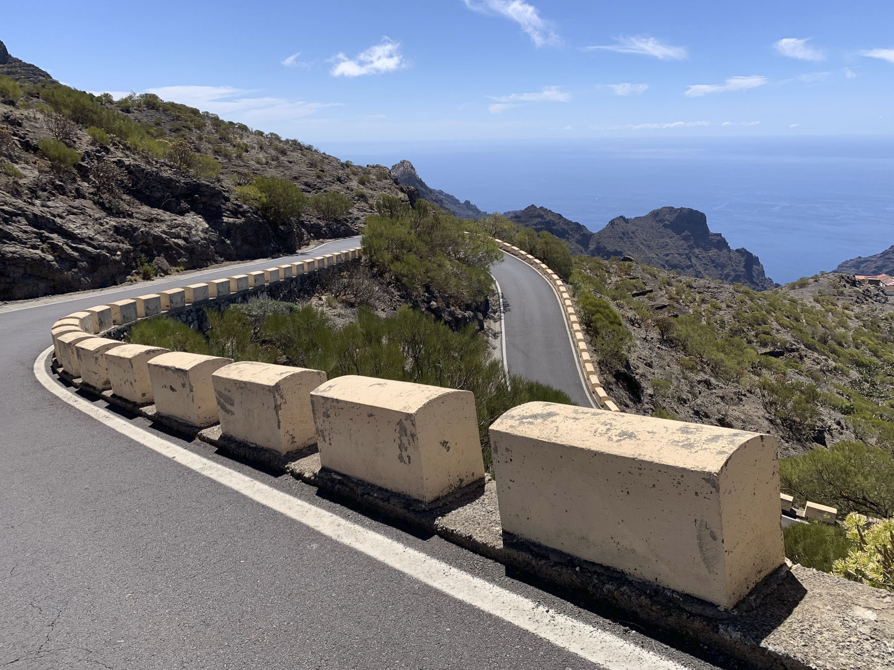
Early the next morning we headed towards Puerto de Santiago on a route that took us to the mountain ridge above Icod. The final destination of the day would be the isolated village of Masca. A serpentine drive from Icod led to a hairpin turn that fed us into Vieja a la Vega, a very narrow steep lane, but really more like an alley lined with homes. This was one of the steepest roads we’ve ever encountered, requiring us to downshift to second gear for the long and seemingly endless ascent to the main road at the top. Fortunately, we didn’t encounter any cars coming downhill, as there was literally no room to pass. At the top we intersected the TF-5 and followed it through an old growth forest covered with stately pine trees. Continuing on, the road traversed a Martian like landscape. A huge lava field that was the result of Volcano Chinyero‘s last eruption in 1909. The terrain became noticeable drier as we crossed the mountain and descended into Santiago del Teide.
The roads to Pico del Tiede, Masca, and Puerto de Santiago converge here, making it the perfect spot for a café break before continuing down to the Mirador Archipenque to view Los Gigantes, a stretch of tall cliff face that dramatically rises straight up from the sea.
From here you can also see two of the other Canary Islands, La Gomera, and La Palma on the horizon. For centuries Santiago was a quaint fishing village, but it has embraced tourism and now draws folks enchanted by its natural beauty and striking location along the coast. Its harbor from November to February is also a popular hub for whale watching excursions to depart from.
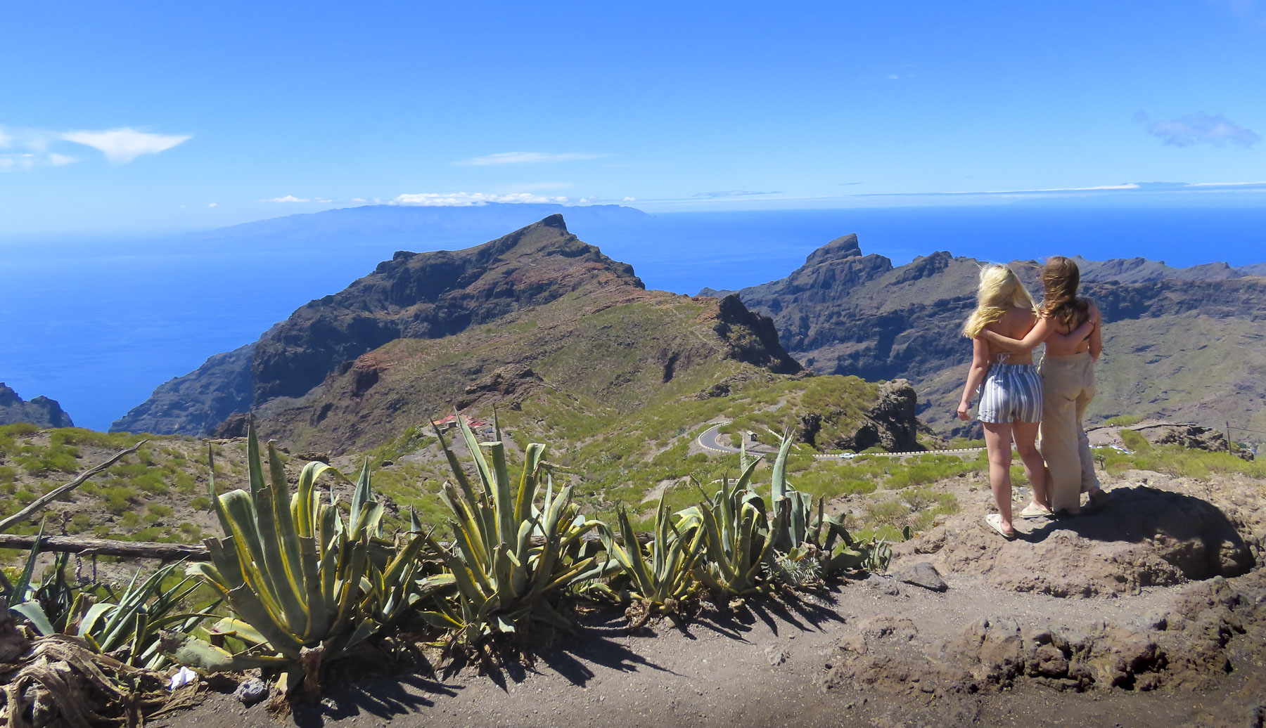
Backtracking through Santiago del Teide we turned into the mountains and followed a long stretch of twisting and turning road to the Mirador de Cherfe. Sitting atop a mountain pass, it has expansive views to the sea. It was also one of the busiest miradors, with vendors selling lava trinkets, and many tourists stopping on the way to or from Masca, like us. Oh, the thrills of driving in the mountains of Tenerife were just beginning!
The isolated hamlet of Masca seems to be a mecca for folks wanting to get into the more remote parts of Tenerife. With limited parking options, we had to wait for a space to become available only to realize after we walked into the hamlet that all the restaurants were closed on Monday. Yikes!
With growling stomachs, we continued on. Starvation was thwarted in El Palmar at the Restaurante El Rincón La Abu, a wonderful establishment where we were the only customers late in the afternoon. The house wine and our meals, pork cheeks in sauce and chicken breast stuffed with serrano ham and spinach, were excellent. We appreciated that we never felt rushed to finish, but we did notice when we were getting into our car that they were locking up for the afternoon. When home our routine finds us having lunch late in the afternoon, but this wasn’t always possible on Tenerife where many of the restaurants close at 2 or 3pm and then reopen later.
It took us awhile to adjust to this earlier lunch schedule. Continuing on we stopped to observe the Montaña Zahorra, an ancient lava dome from which its fertile soil was quarried in the 1960s, 70s and 80s. The distinctive pie shapes of the excavations represented the individual owners’ mineral rights.
Exuberant like rally drivers, we felt victorious from a day well spent and headed back to Icod de los Vinos to enjoy a glass of local wine on the balcony of our room and watch the moon rise over the foothills above the town.
Bright sunlight filled the jet’s cabin as our pilot dipped the plane’s wing into a descending curve that revealed an arid rugged coast, bound by surf and azure waters. Tenerife! The walk to the car park under gently swaying palm trees was refreshingly balmy, a good omen for our visit.
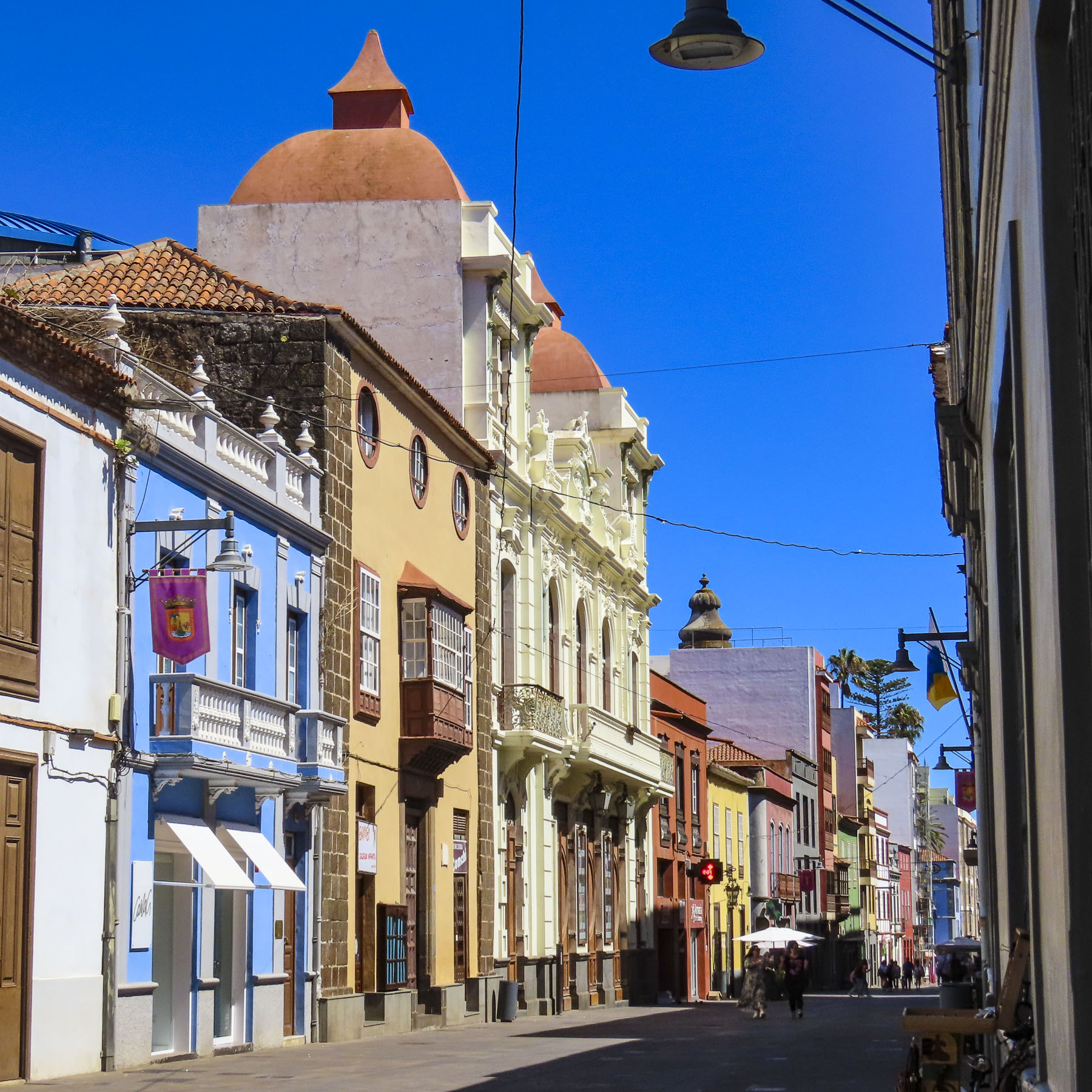
Heading north on TF-1 in our rental car, views of picturesque small villages along the coast awakened our expectations for the days ahead. Our 14 days on Tenerife were divided evenly between stays in Santa Cruz de Tenerife, Icod de los Vinos and La Orotova, with multiple day trips planned from each town to explore the island in depth. Traveling during the September shoulder season, we were able to find some very good pricing for stays at the Iberostar Heritage Grand Mencey, Hotel Emblemático San Marcos, and the Hotel Alhambra.
Three hotels with distinctive character. Santa Cruz de Tenerifewas our first destination, the island’s capital; it is a surprisingly large yet intimate, historic and cosmopolitan port city that offers ferry service to several of the other Canary Islands.
The volcanic seven island archipelago is closer to the coast of Morocco than the Iberian Peninsula. Discovered and populated by folks of Berber origin known as the Guanches around the 5th century B.C., It’s thought their indigenous Canary culture developed in isolation over the next 2000 years until Spain’s Age of Discovery sent fleets of ships south along the African coast in the early 1400s. In 1492, after sailing south from Spain, Christopher Columbus’s fleet of three ships and his intrepid explorers stopped in the Canary Islands to resupply their fresh water and food before catching the favorable, westward-blowing trade winds that carried them across a vast ocean to the discovery of the New World. Tenerife was the last island to succumb to Spanish rule in 1496 after the Guanches were forcefully defeated. For the next 400 years the islands played a crucial role in the colonization of the Americas, sending settlers to help establish Caracas, Buenos Aires, Montevideo, and San Antonio, Texas, along with exporting the first banana plants and sugarcane seeds to the islands in the West Indies. Potatoes and maize, new foods from the Americas, arrived first in the Canaries along with treasure ships laden with silver and gold destined for Spain. The importance of the islands to the Spanish crown was noted by the English privateer and favorite royal bad boy Sir Francis Drake, who found the weather so much more agreeable than England and attacked them in 1586 and 1595. Dutch privateers along with Barbary and French pirates also attacked the islands frequently.
Situated along the tree lined Rambla de Santa Cruz, with its wide pedestrian walkway that runs down the center entire length of the boulevard, the Iberostar Heritage Grand Mencey blended effortlessly into the beautiful 19th architecture that surrounds it. While parking on the street in Santa Cruz de Tenerife is free, there is tremendous competition in finding a space, so we opted to use the hotel’s garage during our stay. Fortunately, our lodging was only a fifteen-minute walk from the city center. It was an ideal location to explore the city from.
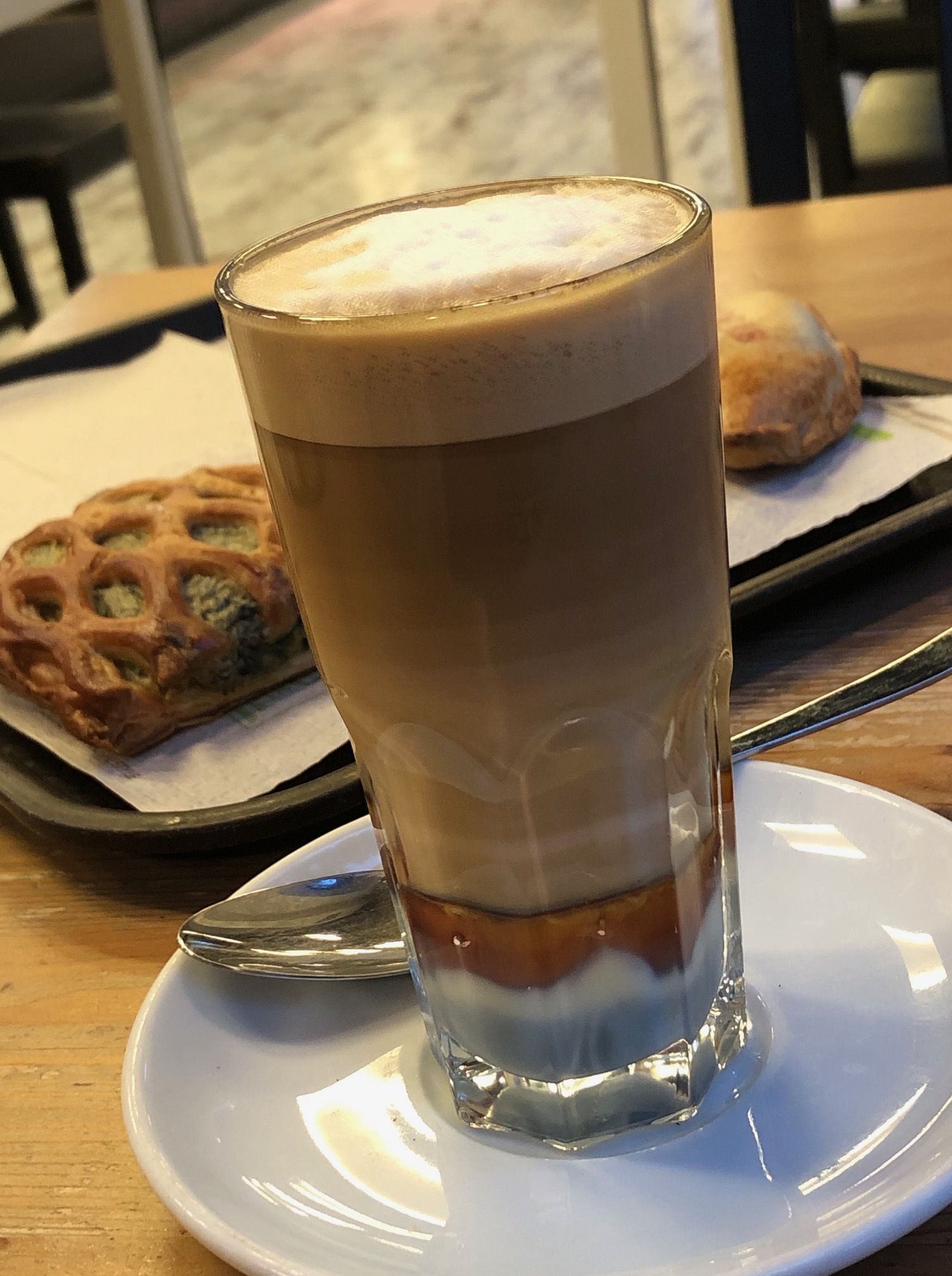
Adjacent to the hotel, the Parque García Sanabrias provided a tranquil sanctuary under a canopy of old growth trees. It’s a huge city park with different gardens, monumental sculptures, and several eateries, and is popular with folks seeking a place to exercise or relax. It’s here that we were first introduced to café leche y leches, a visually attractive layered coffee that was originally created in Santa Cruz de Tenerife early in the 1900s. Surely it was an act of divine inspiration that led to its creation at the Bar Imperial for a loyal customer who always requested the same special coffee. Made with whole milk, condensed milk, espresso, and cinnamon, its popularity quickly spread across the Canaries. Made with an additional shot of Liquor 43, it’s called a “Barraquito,” in honor of the customer who inspired the drink’s creation.
Walking through the city on the way to the harbor and the Palmetum one day revealed a vibrant combination of old and new. Beautiful historic buildings and grand sculptures dotted our route. We were surprised to find that the city also has a modern tramline, the Tranvia de Tenerife, that connects its outer neighborhoods and La Laguna to the city center and port area.
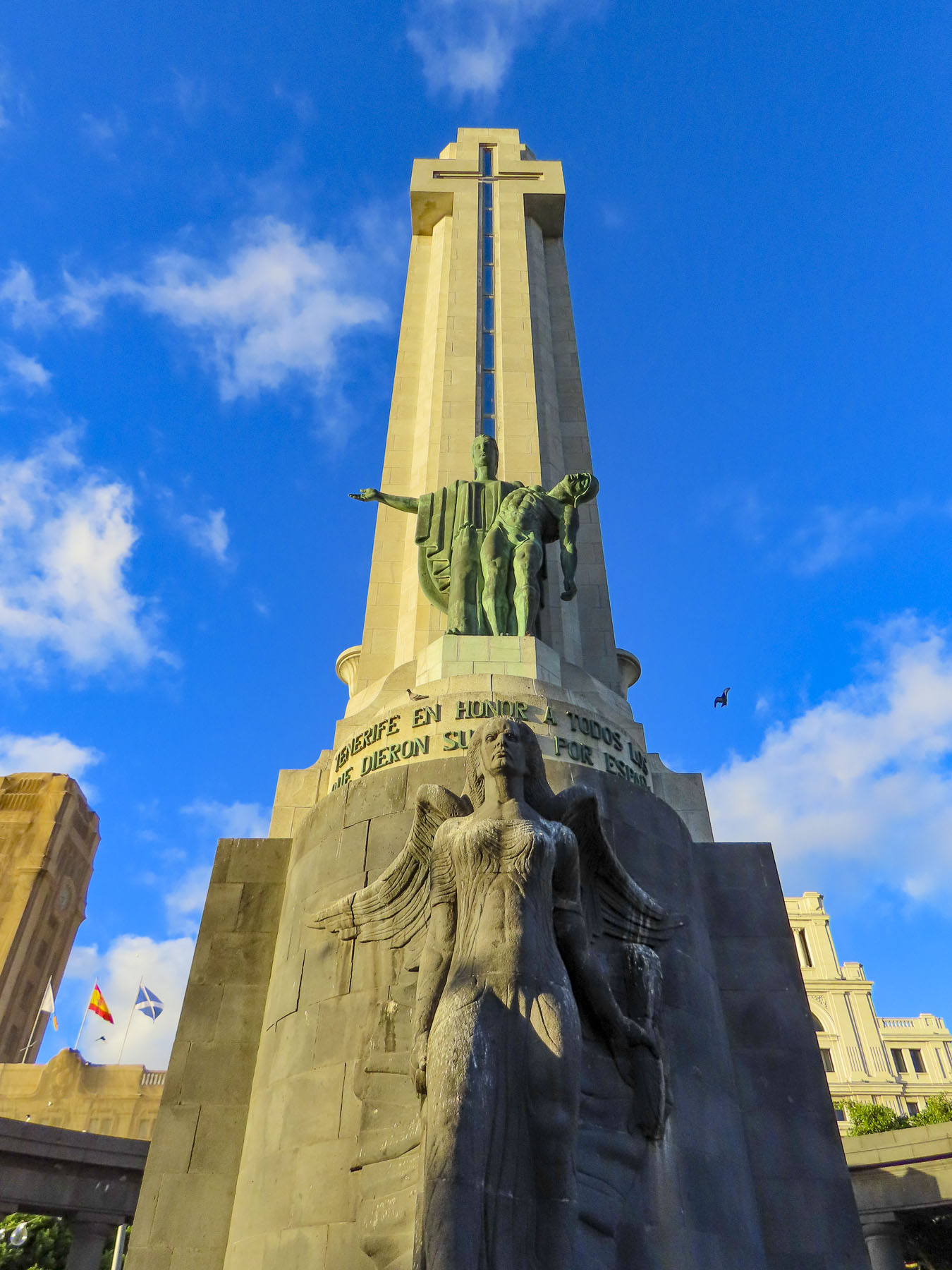
Reaching the Plaza de Espana, we paused to contemplate a tall obelisk, the Monument to the Fallen. A controversial piece today, it was erected in 1947 during the dictatorship of General Franco, and sadly dedicated to the victors in the Spanish Civil War. In 2019 a local government commission determined that the forced labor of political prisoners was used to construct it. And the “monument violates the Law of Historical Memory, and it needs to undergo a resignification process.” Nearby stands a contemporary sculpture called “Lo llevo bien,” or “I’m doing well,” by Julio Nieto, a Basque artist based in Tenerife. It’s a 16-foot-tall stainless-steel sculpture shaped like a humanized tree. A re-interpretation of Atlas carrying the world on his shoulders, Nieto’s piece symbolizes “the optimism of the human being, who, despite all his thoughts, carries it well.”
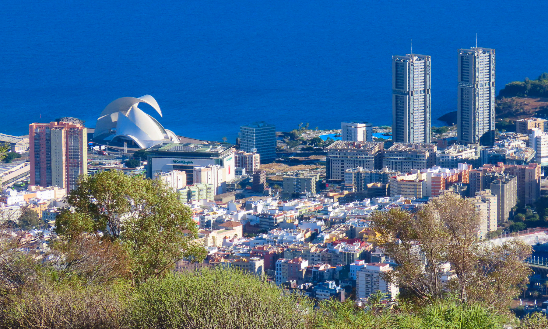
Looking back at the city from the park’s edge, the rectangular modern shapes of the city contrasted sharply with the jagged silhouette of the rugged Tenerife mountains behind them.
We walked along the waterfront to the Auditorio de Tenerife Adán Martín, Santa Cruz’s iconic landmark, an auditorium and arts center, designed by the Spanish architect Santiago Calatrava. Its ultramodern design reflects Tenerife’s prosperity and optimism for the future.
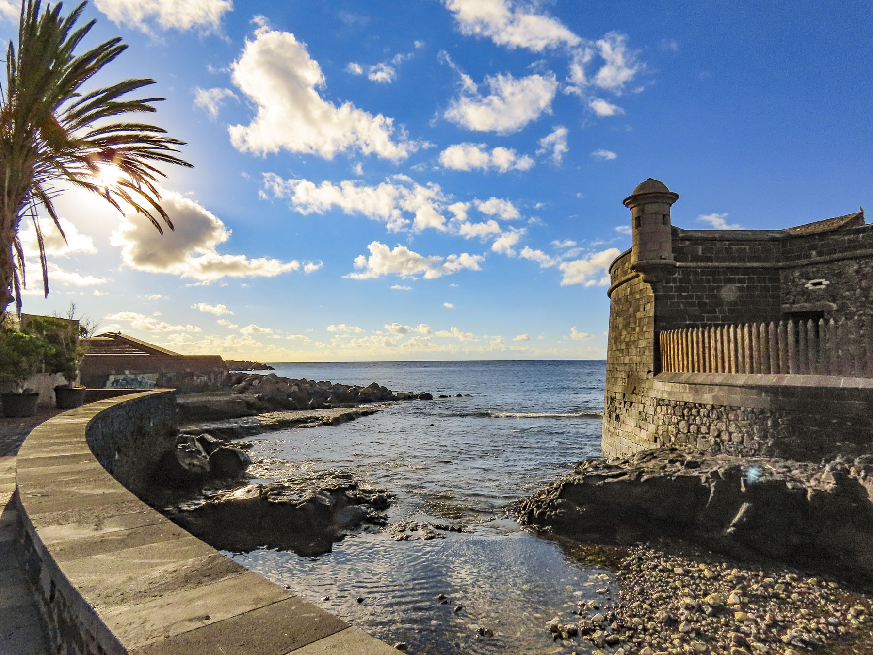
From there it seemed as if we were walking back through time as we passed the Castillo de San Juan Bautista, a short circular fortress constructed in 1640s to defend Santa Cruz from pirate and British attacks, and the Ermita de Nuestra Señora de Regla, a small church that dates from this era.
Reaching the Mirador Caribe at the Palmetum, we were rewarded with an expansive view of the city with Auditorio de Tenerife, and Parque Maritimo iCesar Manrique. A botanical garden, the Palmetum was started in 1995 atop 30 acres of reclaimed land that was once a landfill. Now it’s filled with nearly a thousand palm trees gathered from around the world and other plantings. It’s a spectacular place.
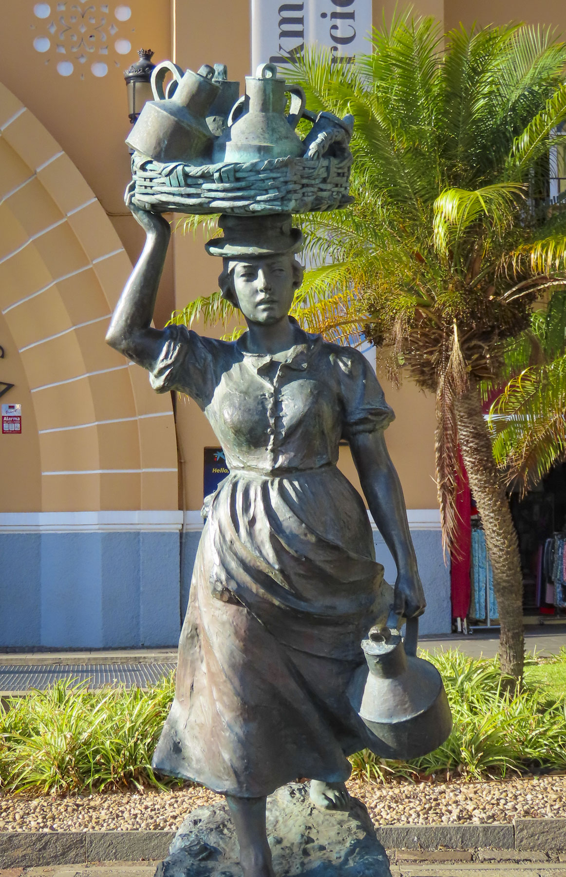
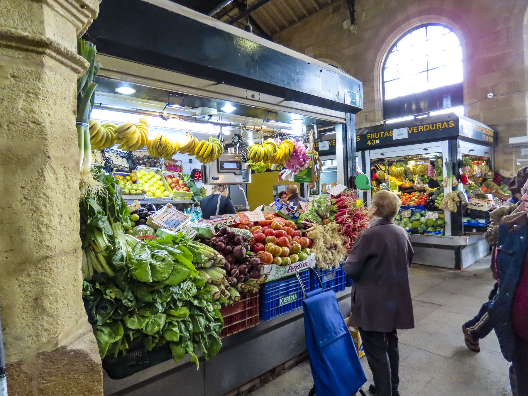
Heading back through the city, we stopped at the old-town market Nuestra Señora de Africa; it’s a sensory experience with colorful fruit displays, aromas of fresh baked goods and the clattering of commerce. Originally an open-air market, it was reconfigured in the 1940s. Built in a neo-colonial style, its arcaded shops and plazas attract locals and tourists. Outside the main entrance two statues reminded us of the old way of life on Tenerife when men still rowed heavy wooden boats through the surf to fish and women called Lechere would walk from village to village with baskets balanced on their heads, carrying jugs of milk to sell.
We finished our walk to the hotel down the wide pedestrian walkway in the center of Rbla. de Sta. Cruz, so we could get a better look at some of the interesting architecture that we passed when we first drove through town.
The weather on Tenerife can be fickle, sunny, foggy, rainy, and cloudy all within the same hour, as it was when we headed northeast early the next morning to the small village of San Andrés for breakfast, before visiting Playa de Las Teresitas, a wide manmade beach of imported yellow sand built behind a series of protective breakwaters. Across from the small café where we had breakfast under a threatening sky stood the ruins of Castillo de San Andrés, a small round fortress built to deter pirates from landing and ransacking the village and Santa Cruz. As British troops attempted to land in 1797 and seize Spanish treasure from the Americas, it’s believed a canon shot from this fortress wounded the famous Admiral Horacio Nelson, causing the amputation of one arm. This cannon is oddly on exhibit in the museum at the Castillo de San Cristobal in Santa Cruz. During the 18th and 19th centuries flooding from the stream next to the castle undermined its foundation causing it to split into almost even pieces, like a cake sliced in half.
Above the beach the Mirador Playa de las Teresitas offers tremendous views south of the coast. Turn around and walk a few yards back along the road for a spectacular view of the black sand beaches Playa de Las Gaviotas and Playa Cueva del Agua.
Any resemblance to a straight road disappeared as we turned onto TF-12 to work our way across the island to Playa del Roque de las Bodegas, the Mirador de Playa Benijo and continue onto the El Draguillo mirador in an isolated hamlet in the Anaga Rural Park.
Distance between sites on Tenerife are relatively short as the crow flies, but the roads are narrow and serpentine, so the driving is slow, even though not many cars are on the roads. Rising into the mountains, the terrain changed from arid browns to verdant greens. The views along the way of isolated villages hugging the steep slopes were awesome.
Our intent was to drive all the way to the El Draguillo Mirador, as our GPS map led us to believe was doable, but the road ended at a very small gate in a muddy car park with a sign that said only residents of the village were allowed to drive past this point. Evidently this is the starting point for the El Draguillo trail, a 6 hour hike. The parking lot was jammed full and it took a serious multipoint K turn to get us out. We recovered nicely though by having a great lunch nearby at La Venta de Marrero, a cliffside restaurant with a fabulous view.
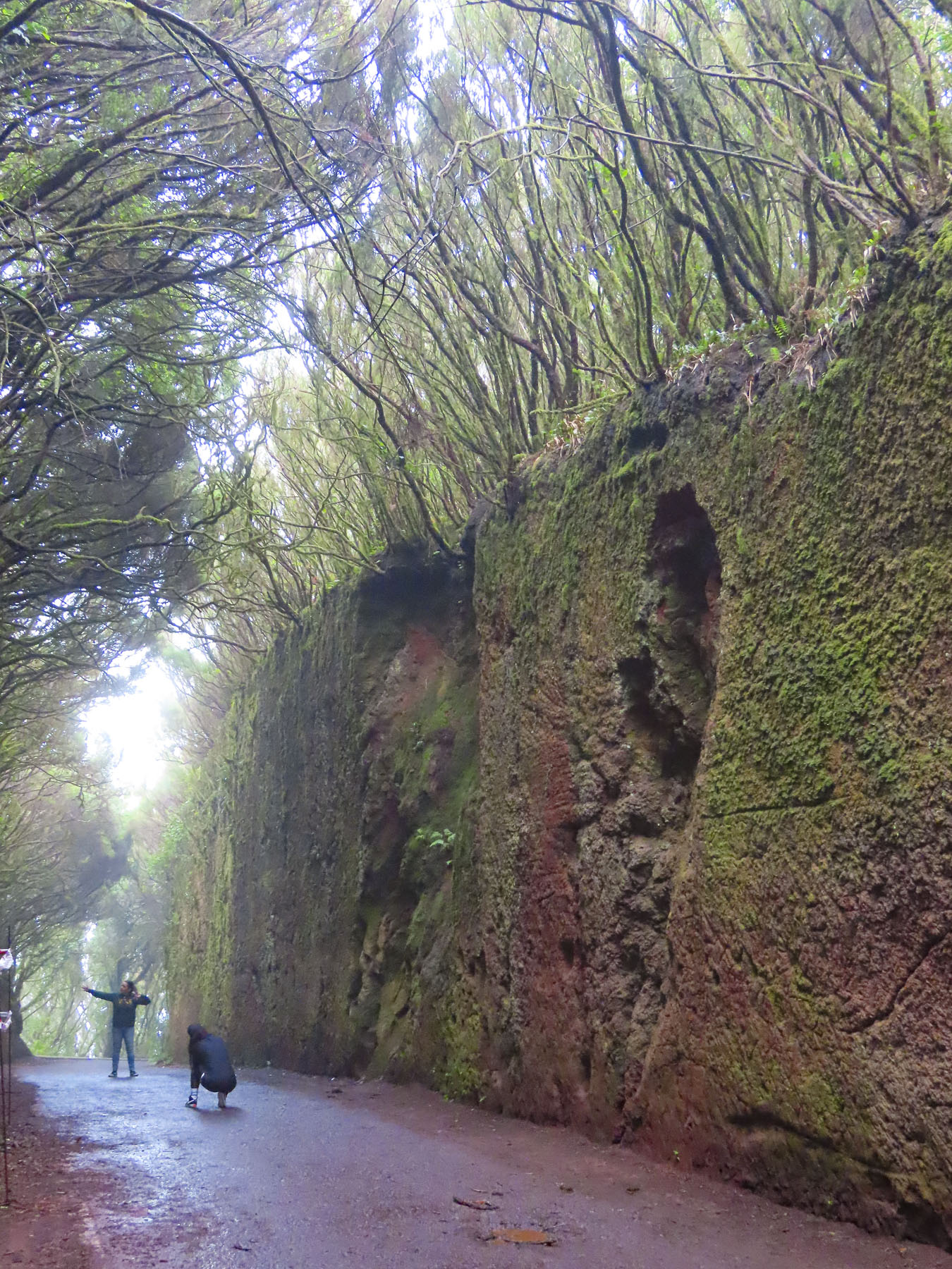
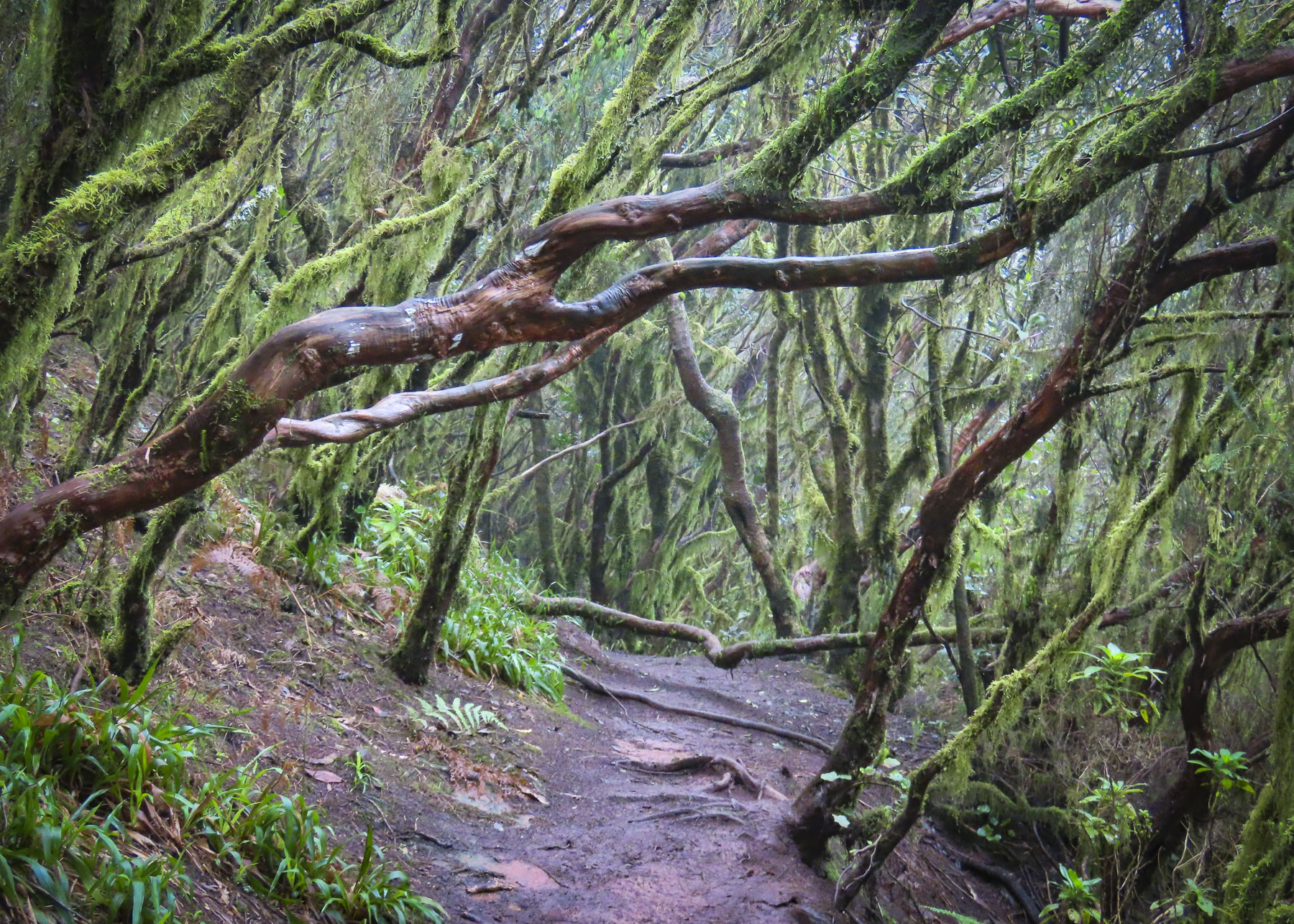
Scenes obscured by fog and low clouds as we drove across the mountainous interior that morning were now brilliant in the afternoon sunlight as we headed toward the Túnel de las Hadas. It’s a mesmerizing channel covered with moss, that was cut through the surrounding laurel forest. It is located in the Parque Rural de Anaga, which is recognized as a biosphere reserve with the largest number of endemic plants in Europe. The fog rolled in again and it was enchanting.
Our last day trip from Santa Cruz was to San Cristobal de La Laguna, an old colonial city that on its founding in 1497, after the defeat of the indigenous Guanche kingdoms, became Tenerife’s and the Canary Archipelago’s first capital. The village at first grew haphazardly around the Iglesia de la Concepción.
These first dwellings, built mostly of reeds, were ordered to be replaced in 1502, as their building material threatened to destroy the growing town if it ever caught fire. By this time La Laguna was the largest city in the Canaries with 6000 thriving inhabitants, two large churches and several monasteries. The city leaders adapted a plan Leonardo Da Vinci created for the city of Imola, Italy, as a blueprint for their city. Local son and Jesuit missionary José de Anchieta is credited with the inspiration to use this design of La Laguna when he founded the cities of Sao Paulo and Rio de Janeiro, Brazil, in the mid-1500s. The priest is highly revered on Tenerife and a venerated wooden sculpture of him from the Cathedral of La Laguna is carried in procession through the streets every June 9th.
On the flip side of good there is always bad, and San Cristóbal de La Laguna also recognizes another historical figure from their city, Amaro Pargo, a famous corsair, from, as the Spanish like to call it the “Golden Age of Piracy,” who savaged ships flying the British and Dutch flags sailing to their colonies in the West Indies. With a reputation as notorious as Sir Francis Drake’s, he was also recognized for his services by the Spanish crown and was declared a Caballero hidalgo, a knighthood, in 1725. He was also a merchant with many business interests and during his time the richest man in the Canary Islands, who was also highly regarded for frequent and large religious donations. He had an interesting relationship with a nun from the Catedral de San Cristóbal de La Laguna, Mary of Jesus de León y Delgado, who he credited with saving his life during a fight in Cuba by her ability to bilocate. Sister Mary is an interesting individual in her own right, credited with miracles, acts of healing, clairvoyance, levitation, psychokinesis, and stigmata. Sister Mary’s incorrupt body is preserved in the Monastery of St. Catherine, where she lived for 63 years, without ever leaving. Every 15 February her ornate glass-covered coffin, gifted by Amaro Pargo, is placed on display in the convent. With 1,251 miracles attributed to her, she has been nominated for canonization.
Though La Laguna is over 500 years old, it hosts a 300-year-old university with nearly 25,000 students that keeps it young at heart. Vibrantly colored buildings are interlaced between traditional examples of Canary architecture that feature wooden balconies that face the street and have deep courtyards to provide a shady sanctuary from the midday sun. The city’s major buildings incorporate a variety of styles that have been trendy across the centuries.
Older Gothic, Baroque, and Renaissance style buildings dot the historic center, while Neoclassical elements are present in the newer 18th century buildings that were built around the city’s core. In other words, there’s a delightful hodgepodge of architectural styles to enjoy.
Some of the older buildings have now been re-envisioned as exhibition spaces, as was the deconsecrated Ermita de San Miguel, which hosted a show of 3D printed sculptures when we visited. Others are now hotels or restaurants. The historic core of the city is pedestrian only and as we like to say “walk a little then café” is the best way to explore it.
Returning to Santa Cruz, we detoured into the mountains above the city to Parque de Las Mesas for an expansive view of the city below us. Brilliant in the afternoon sun.
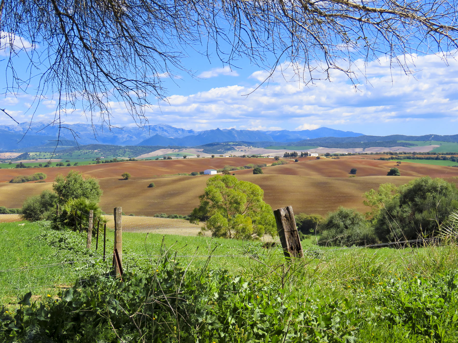
Just below the northern horizon, a white brushstroke highlighted the verdant canvas before us as we savored the view from the top of the castillo in Castellar de Frontera one last time. That swath of white slowly changed into Jimena de la Frontera as we drove closer. One of Andalucia’s famed Pueblos Blancos, the village is set on the hillside below the ruins of its ancient castle which once protected it.
In ancient times the homes in villages featured roughhewn stone masonry. Lime paint was a luxury, until its use was greatly expanded during the mid-1300’s when a bubonic plague pandemic swept through the Mediterranean countries. Residents of villages were required yearly to cover the outside and the interiors of their homes and churches with a limewash, known for its natural anti-bacterial and insecticidal properties, in an effort to reduce the spread of disease. Community inspections were done, and folks were fined for noncompliance. This mandated conformity was eventually appreciated as an aesthetically pleasing look and a symbol of meticulous tidiness. Fortunately, the custom stayed and has become an iconic signature of southern Andalusia.
Villaluenga del Rosario was our ultimate destination for the day, but before that we would be driving through the expansive forests of Parque Natural Sierra de Grazalema and stopping along the way in Ubrique, and Benaocaz. All pueblos blancos, though all different in size, setting and atmosphere. According to our maps app the trip would take 2 hours. But it was a glorious 58-mile sinuous route through the mountains, and with several stops it took us most of the day.
The vast 130,000-acre Parque Natural Sierra de Grazalema, with peaks reaching 5400 feet, is one of the wettest areas in Spain, receiving almost 80 inches of rain a year. This is surprising, considering that many areas in Andalucia are often used to replicate the American southwest for European filmmakers. These wet conditions over many millennia have created a dramatic karstic landscape of shear mountains, lush valleys and caves, especially Pileta Cave with its 30,000 year old prehistoric paintings. The park’s lower elevations feature forests of cork oak, carob, hawthorn, and mastic. Higher slopes transition to a landscape of gall oaks and Spanish fir, a tree species that survived the last Ice Age. This ecosystem supports a diverse fauna that contains 136 species of birds, most notably a large population of griffon vultures, and 42 mammal species, that include foxes, badgers, roe deer, otters, and Spanish ibex. And in ancient times it was the refuge of wild, now extinct, aurochs, the ancestor of the famous Spanish Fighting Bulls, toro bravo. The park has been a UNESCO Biosphere Reserve since 1977.
Farmers still harvest cork and olives amidst the rocky terrain and graze cattle, sheep, and goats within the park. This practice made for an interesting encounter when we rounded a curve and faced a VERY LARGE BULL standing in the middle of the road, adjacent to some pasture. We stopped, looked around for his farmer, but there was no one in sight. It was obvious he was the king of this domain, with no intention of moving aside until he felt like it. Slowly we inched forward and watched him eye us until he decided to saunter across the road and let us pass.
Ubrique is a large thriving town with 17,000 inhabitants set in a valley surrounded by tall peaks and steep scree slopes, its homes built above and around boulders too large to move. The town’s prosperity comes from its fine leather workshops, which account for 60% of the townspeople being employed directly or indirectly in the creation of leather products. It started simply enough with leather cases and pouches to carry tobacco and the Precise, a heavy-duty strap that allowed workers to safely carry silex stones and iron bricks.
By the mid-1700s their fine leather products and artisanal craftsmanship was recognized across Europe which fueled an export industry. The good fortunes of the town continued to grow until the mid-2000 when clients seeking higher profit margins moved their leather goods production to China and other Asian countries. Fortunately, their exodus did not last long, and they returned to Ubrique when they realized that the excellent craftsmanship in this small Andalucian town could not be rivaled by cheap labor. Today Ubrique is considered the “artisanal leather capital, “ for high-end fashion brands like Chloe, Gucci, Hermes and Louis Vuitton. “So many stores, so little time.” Of course, we shopped! The decision-making process was painful, but Donna managed to select one single beautiful purse to take home.
In March the twisting roads, higher into the mountains, were nearly void of traffic. Occasionally a campervan passed. Reaching Benaocaz, we parked and strolled through a nearly empty town square in search of coffee. It was a quiet weekend afternoon in the shoulder season, and few people were about, but luckily, we happened to come across Restaurante Nazari, a rustic restaurant with outside tables that had a view of the valley below the town.
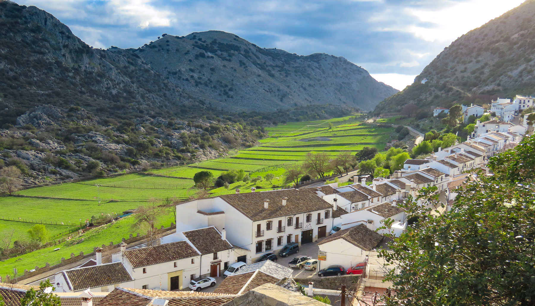
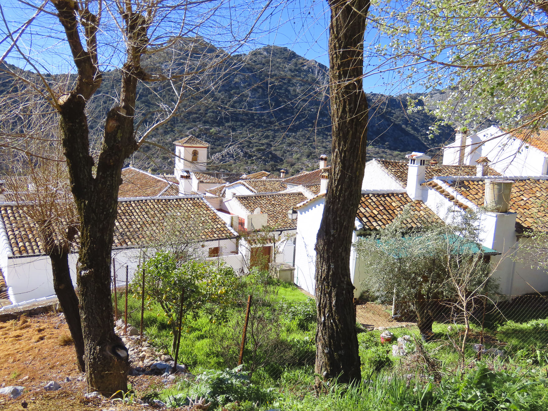
Villaluenga del Rosario was only a little farther, and higher into the mountains. The village is dramatically set along one side of a narrow green valley at the base of a sheer mountain massif. The lane to our inn, the Tugasa La Posada, looked too narrow to drive down, and I was concerned about getting to a point that required backing up. A difficult task in an alley barely wider than our rental car, and there was plenty of parking above the village. La Posada wonderfully reflects the typical inn of centuries past, with a large tavern, featuring regional recipes, on the ground level and a handful of rooms above.
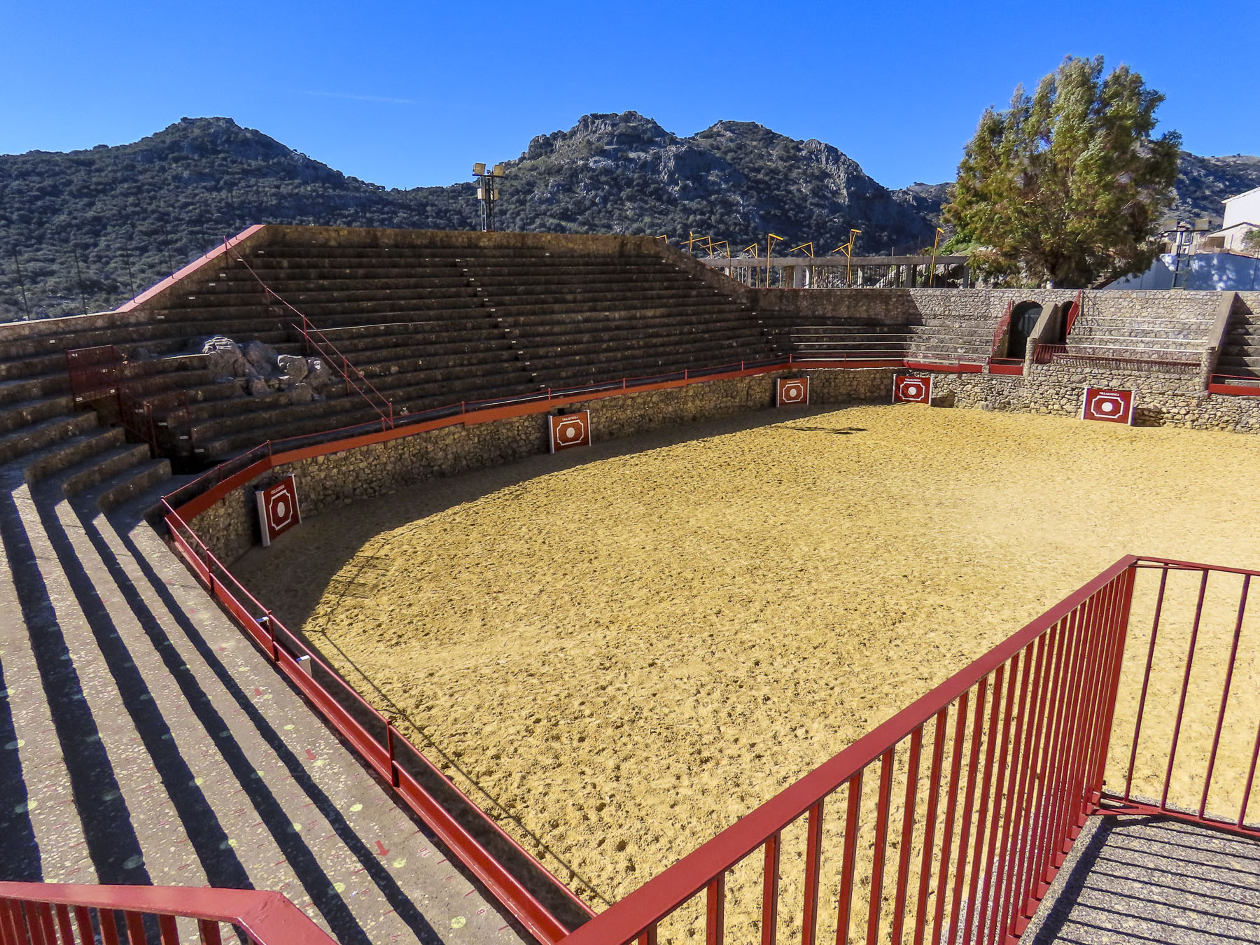
Several things are unique to this pueblo: Snowy winters are common in the Sierra de Grazalema Natural Park’s highest village, situated at an elevation of 2800ft. It is also the smallest village in the Province of Cadiz, with only 438 residents. And the village has a unique octagon shaped bullring, built around a natural rock formation, that is the oldest in Cadiz Province, dating from the mid-1700s. The exact year of construction for the bullring isn’t known, as the town’s archives were lost in a 1936 fire. Located on an important cattle trading route through the mountains, the bullring was also used as a corral during livestock festivals.
But before domestic cattle were raised in the area, prehistoric people used to pursue auroch, a wild bull that lived in the Sierra de Grazalema until it was hunted to extinction in the Middle Ages. Nearby in Cueva de la Pileta, primitive cave paintings of bulls have been dated to the Paleolithic era 27,000 years ago. The famous fighting bulls of Spain, Toro Bravo, descend from this primal auroch lineage that once roamed wild. Ancient pagan festivals often conducted a running of the wild bulls, tethered to a group of men by a long rope, through their villages before a ritual sacrifice. “Toro de Cuerda'”(Bull on Rope) festivals, are thought to be the foundation of the modern Spanish Bull Fight, and are still held in Villaluenga del Rosario, Grazalema, and Benamahoma. With the advent of Christianity some of these pagan elements were incorporated into church celebrations of a pueblo’s patron Saint. In Grazalema the early church Christianized the practice and includes the Feast of the Bull in celebrations to the Virgen del Carmen every July. Benamahoma’s “Toro de Cuerda” is held in August during their festival to honor the town’s patron saint, Anthony of Padua.
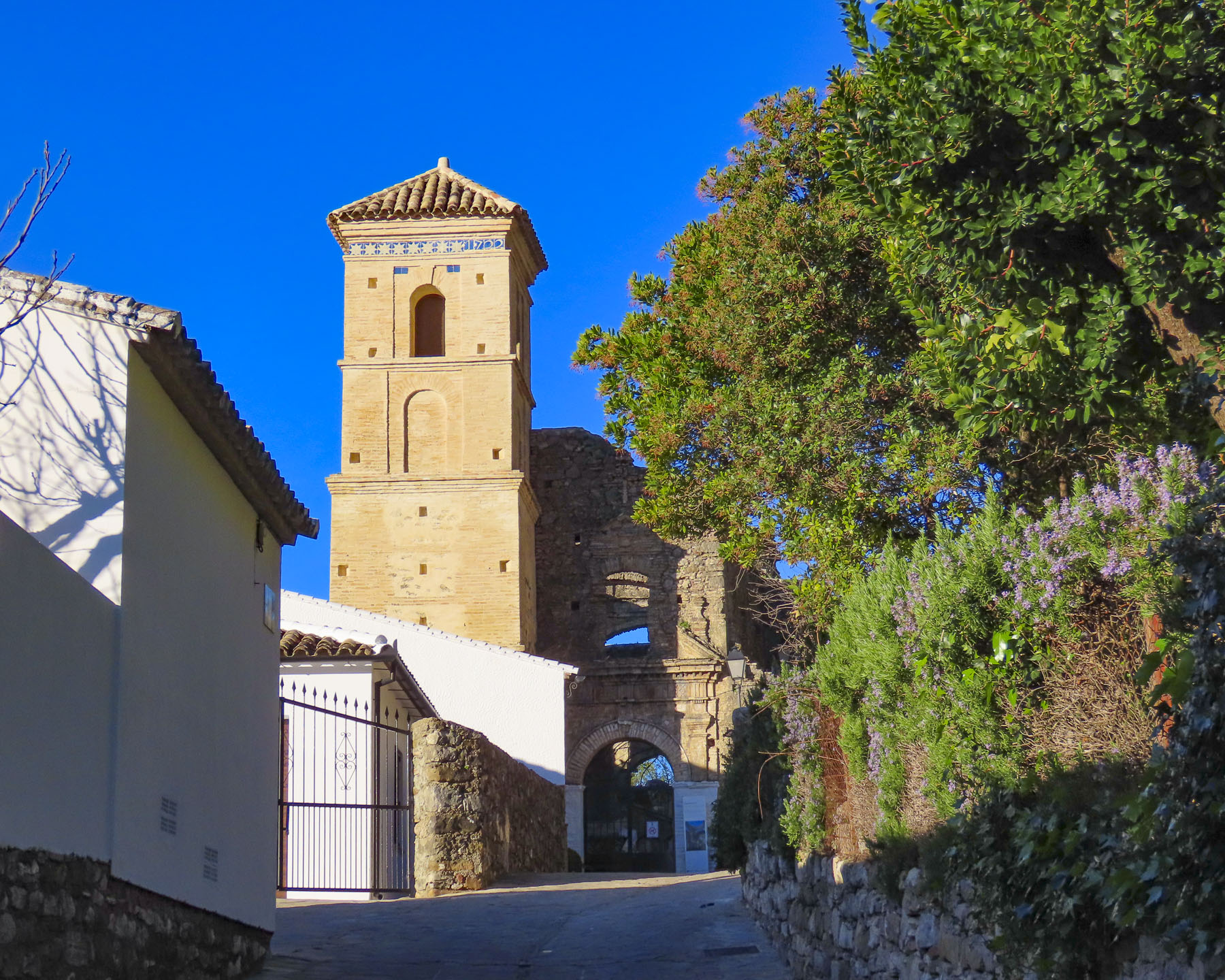
This tranquil village has gone through some turbulent times in its past. Villaluenga del Rosario, known for its woolen textiles in the 17th century, did not escape Napoleon’s destruction as his troops retreated across the mountains after they abandoned their siege of Cadiz in 1812. French troops sacked the village and torched the old Church of El Salvador. Now only the walls and roof arches remain, open to the sky. The sanctuary is now used as a cemetery. The economy declined throughout the region in the 1800s and early 1900s, and the mountains were beset with bandits. Notoriously, José María El Tempranillo and Pasos Largos, the most infamous of the Sierra’s outlaws, would frequent the village and hideout in the surrounding caves. They are celebrated as Robin Hood bandoleros, robbing the wealthy and redistributing their stolen goods to help the poverty-stricken locals – Andalucia’s mountain justice. These same caves in the 1930s would shelter Republican resistance fighters escaping Fascist troops during the Spanish Civil War. A hiking trail, Los Llanos del Republicano, from the village to caves is named after them.
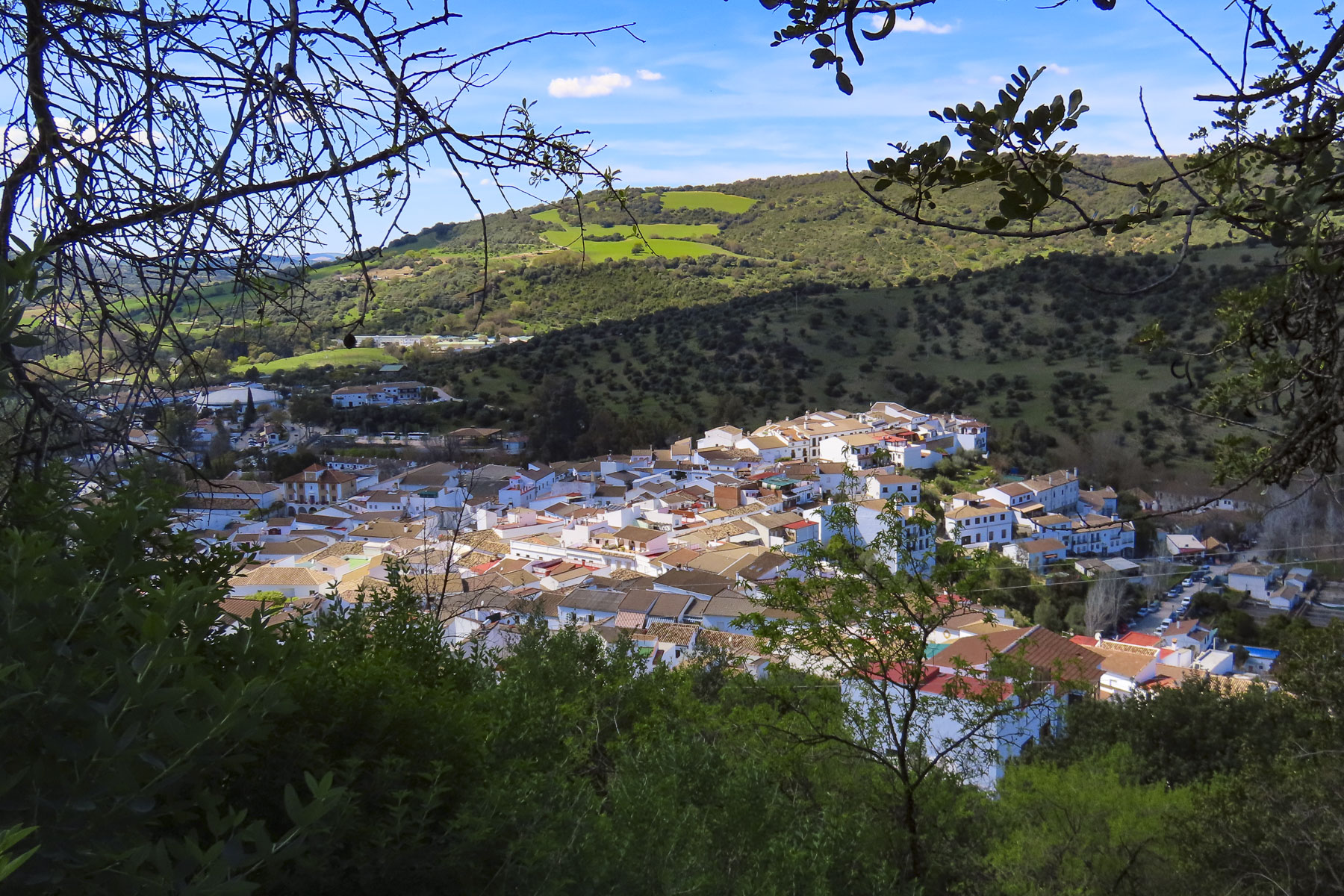
The rural population continued to emigrate, contributing to further economic deterioration until the villages’ employment prospects improved with the opening of a cheese factory, Queso Payoyo, in 1997. The Payoyo goat is an ancient breed from the Sierra de Grazalema and considered endangered. Since Queso Payoyo opened 25 years ago, its goat and sheep cheeses have received 175 national and international awards. Thirty-five farms now supply Payoyo goat and Merina grazalemeña sheep milk to the cheesemaker. Their shop just across the road from the village seems to be a Mecca for cheese aficionados. Open seven days a week, we were surprised to find it packed with customers early on a Sunday morning, when we stopped to buy some cheese before we headed to Benamahoma.
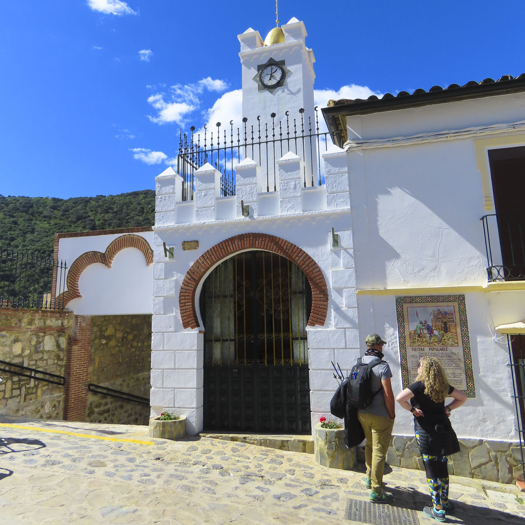
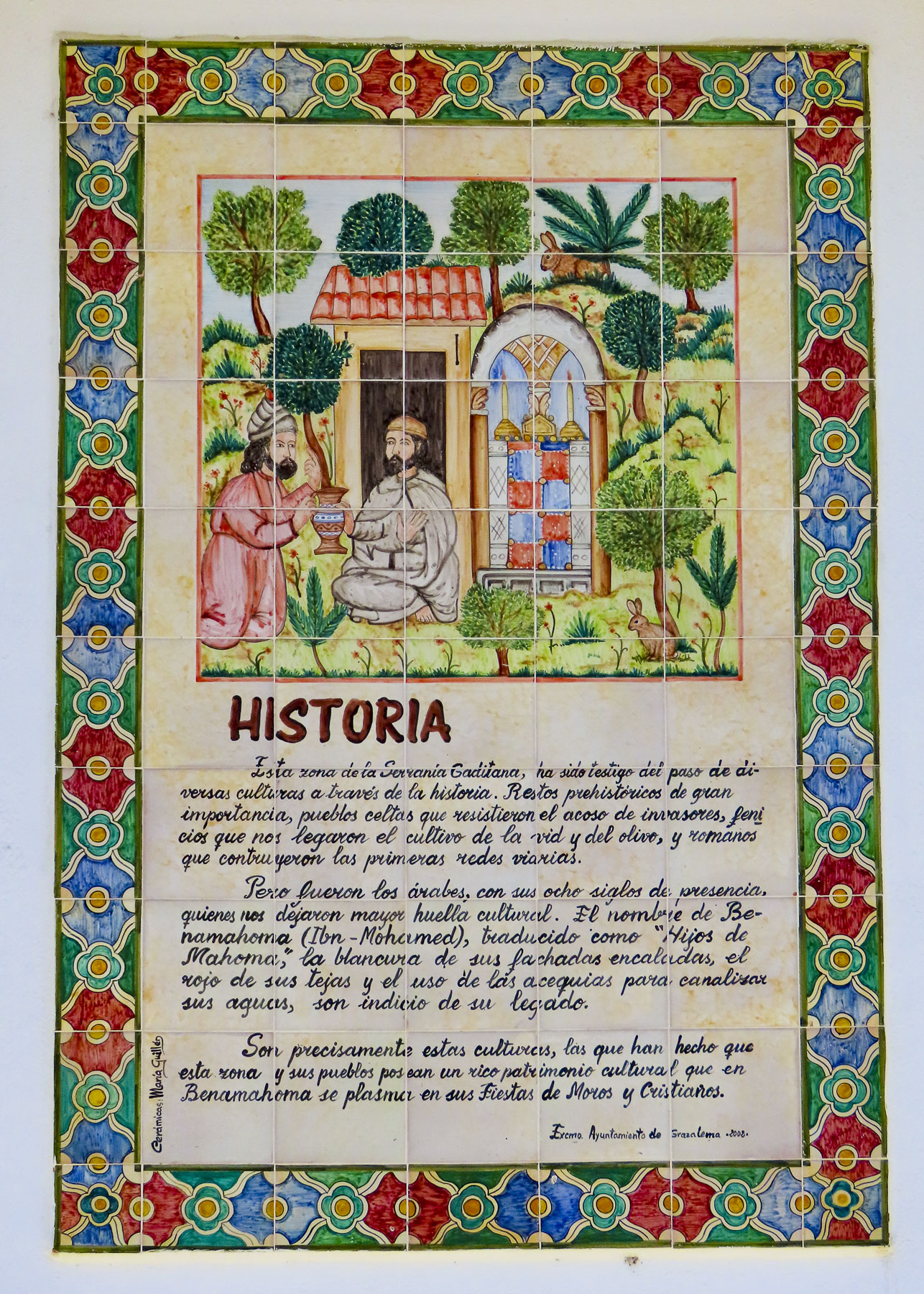
It was a beautiful crisp spring day, and we enjoyed a slow walk uphill into the village. Next to the Plaza de las Huertas the façade of the Ermita/mezquita de San Antonio, a church/mosque, visually represents Benamahoma’s complex cultural identity, with Moorish horseshoe-shaped arches and three golden spheres topped by with a gold crescent, typically seen on minarets, atop its tower.
This region in Spain has a very complicated history, beginning with Alfonso X’s Reconquista which started in the mid-1200s, paused, then continued for the next 400 years with his successors. Benamahoma was the last Moorish village in the mountains to have its inhabitants expelled from the region in 1609, eighteen years after Grazalema’s Muslim villagers were forced out, though the hamlets are only nine miles apart. Their reprieve was caused by the fact that although Alfonso X and later Kings achieved military victories, they did not have enough troops to garrison each village, nor sufficient numbers of willing Christian settlers from Northern Spain to repopulate the conquered towns. Consequently, to keep the economy of the area going and subjects to collect taxes from, Moors were allowed to stay as long as their local Princes swore allegiance to a Christian King and declared themselves loyal vassals. This did not always go smoothly and there were rebellions. Most famously the Mudéjar Revolt in 1264, when the towns of Jerez, Lebrija, Arcos, and Medina-Sidonia were recaptured and occupied by Moors for several years before Christian armies secured the towns once again.
Benamahoma’s historic, pragmatic tolerance is celebrated the first weekend every August with a Moros y Cristianos Festival. Carrying swords, shields and blunderbusses, historical reenactors dressed in period clothing parade through the village to the bullring, where they then engage in mock hand-to-hand combat. The battles are won with the capture of an image of San Antonio de Padua by the Moors on Saturday and then won by Christians on Sunday with the rescue of his image. Many of the positions in the opposing armies are hereditary, the tradition being passed down from father to son, through the generations. Benamahoma is the only village in western Andalucia which celebrates this festival.
This village’s remoteness in the Sierra de Grazalema did not protect it from the atrocities committed during the Spanish Civil War. Near the bullring, in the Parque de Memoria Historica, silhouettes stand where villagers once stood against a wall before they were massacred by Fascists. Sadly, this memorial is also near the village’s second church, the Iglesia de San Antonio de Padua.
Backtracking as we headed to Arcos de la Frontera, we stopped at a radio station above El Bosque. A trail behind its tall antenna offered the perfect vantage point to capture a photo of the village below. We did not stop in El Bosque, but after catching glimpses of the village as we drove through, in hindsight we wished we had. But there was a time constraint, we wanted to spend the afternoon exploring Arcos de la Frontera, before flying on to Barcelona the next morning.
The A-372 between El Bosque and Arcos de la Frontera has to be one of the prettiest stretches of highway anywhere. With the reflection of the Sierra de Grazalema in our rearview mirrors, we wished we could have lingered longer.
I’ve always loved maps for researching routes, finding obscure sites, and figuring out the best vantage point to capture a landscape from. This brought us to our first two stops at the Molino de Angorrill, an old mill, and the Mirador Los Cabezuelos, before we entered the hilltop citadel. Both places along Guadalete River had wonderful views of the ancient city.
After this our map app failed us when it suggested we head the wrong way down a one-way calle into the village. We eventually found an underground parking garage at Parque El Paseo and towed our suitcases uphill to the Parador de Arcos de la Frontera.
It was LONG walk, but of course we stopped frequently to take photos. Located next to the 500-foot-high Mirador Plaza del Cabildo and adjacent to the Basílica de Santa María de la Asunción and the Castillo de los Duques de Arcos, the hotel was a perfect base for a one-night stay. Formerly the Casa del Corregidov was an Andulcian palace before it was acquired by the government and renovated to be a paradorin 1966.
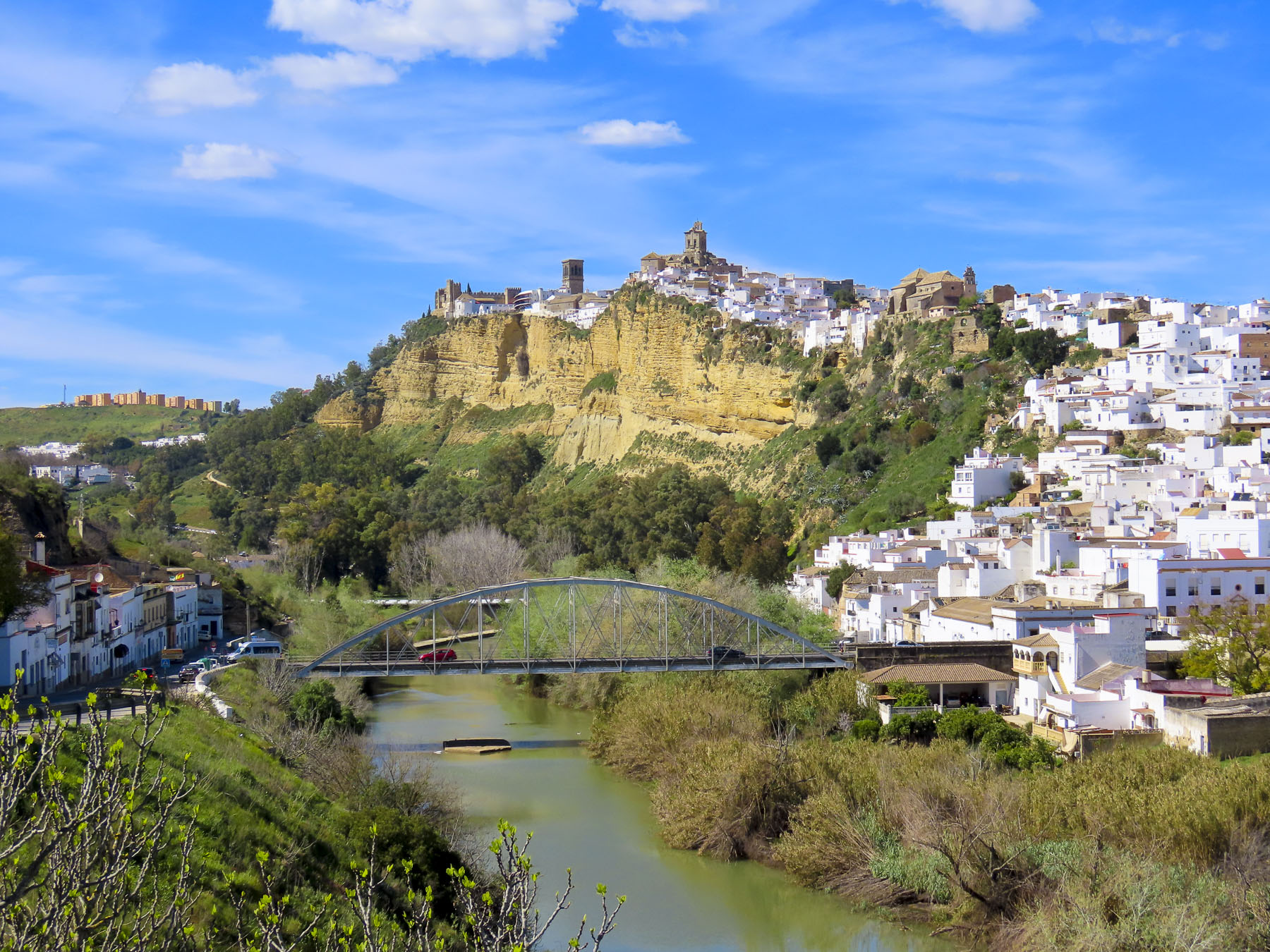
Arcos has always been a favored spot, appreciated for its access to abundant water sources and its easily defensible position atop a cliff face. It has hosted settlements since the Neolithic period, Bronze Age, Tartessians, Phoenicians and Romans periods.
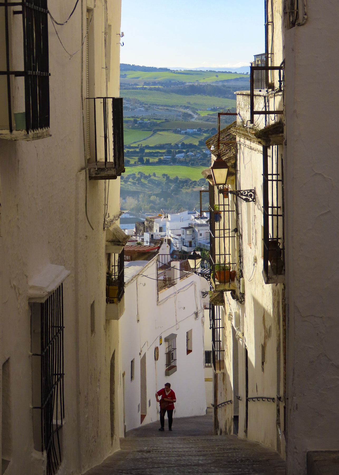
The village continued to grow under the Moors and while the facades and interior of buildings in this ancient town have changed over the centuries the original Arab footprint of the village, with its exceedingly narrow lanes has remained the same.
The view from the mirador and the hotel’s patio were phenomenal during the golden hour. As the sun was setting, a large flock of storks appeared over the bell tower of the Basilica and circled for about fifteen minutes before flying away. It was a magical experience that nicely capped our short time in Arcos.
The next morning, we watched the sun rise over the Sierra de Grazalema and the village’s church steeples from our hotel room, before wandering through the village’s ancient lanes one last time.
“We should tuck the mirrors in,” I said as we eyeballed the passage through the narrow arch ahead of us. We were on the Plaza de Espana in Medina-Sidonia, a forty-minute drive from Cadiz. But we couldn’t be further away, as it felt like a passage in time to centuries past as we drove into the village. Folks have lived on this hill since before the Phoenicians settled Cadiz in 1100 BC, making the village one of the oldest settlements in western Europe. But it is with the Phoenicians and later the Romans, Visgoths, Moors and finally the Spanish that the village grew. Sitting 1,000ft above the fertile rolling plains below, the highest point for miles around, the village offers incredible vistas of the surrounding countryside out to the Atlantic Ocean. The pueblo blanco we see today has its roots with the Moors in the 8th century.
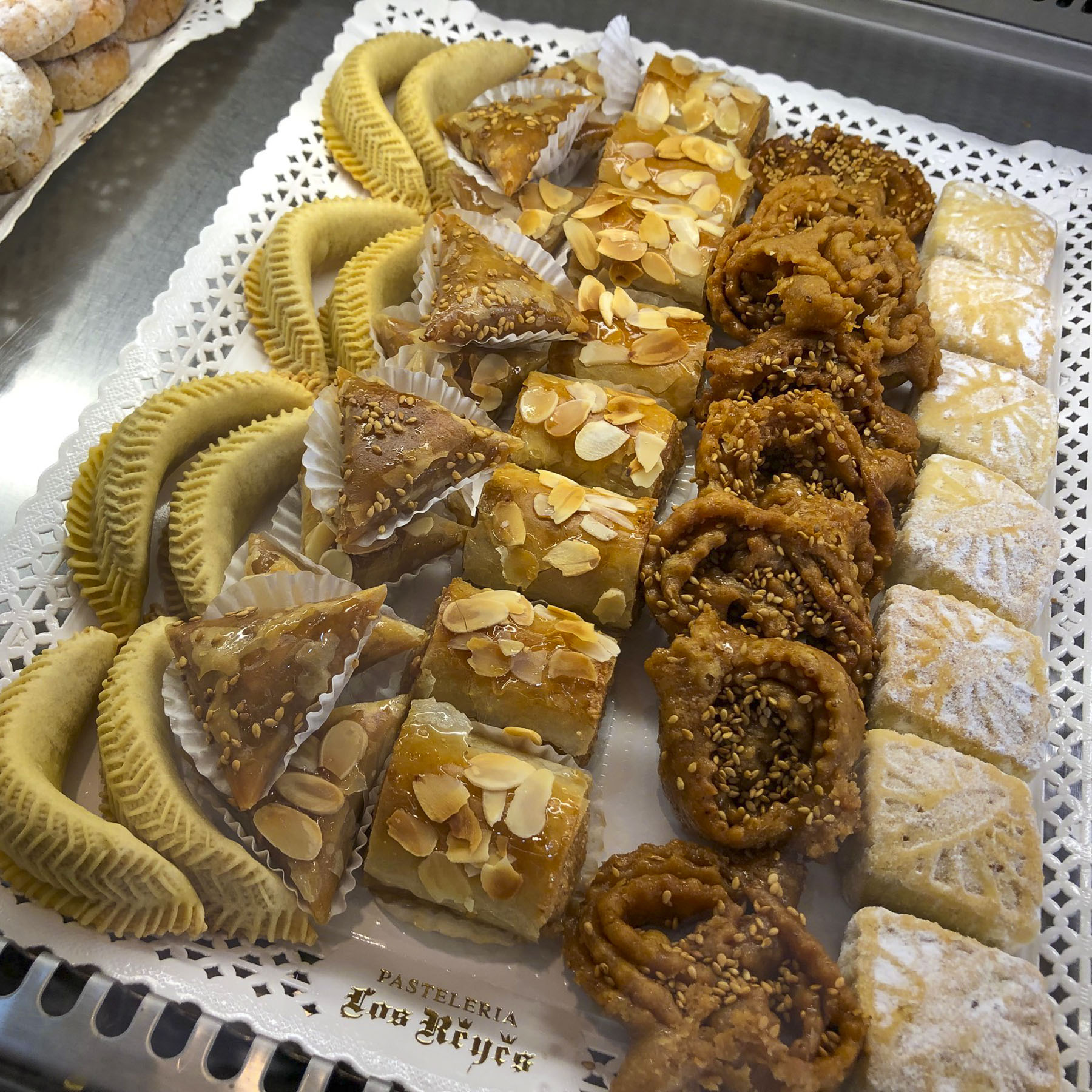
The plaza was nearly deserted when we strolled across it, mid-week in the middle of March, looking for a café. While the plaza was empty, we found a café, Restaurante Paco Ortega, bustling with activity. We ordered Tostadas de Jamón and Alfajor, a sweet gingerbread-like confectionary from the Arab period, that the town is famous for. We enjoyed the tostadas and the lively chatter of the café, but we were pointed across the plaza to Pasteleria Aromas de Medina for the Alfajor. True to its name, delicious whiffs of fresh baked pastries greeted us as we crossed the threshold of temptation. The Alfajor de Medina Sidonia was heavenly. It’s made with local honey, nuts, breadcrumbs, and a variety of spices – what’s not to like? The only question was how much to buy.
The day was really the first one of our Andalucian road-trip. Previously we had stayed for multiple days in Jerez de la Frontera and Cadiz (click to read those blogs.) Medina-Sidonia was the first of two stops, before we stayed in Castellar de la Frontera.
I swear the 12th century Arco de Belén, one of the original gates into the old walled Arab village, was slimmer than the one at the plaza. Located on a narrow, uphill blind curve, it took me two tries to align the car correctly for safe passage through the wall.
It’s a nice walk from the plaza in front of the cathedral to the ruins of the ancient castillo that once crowned the crest of the village. It must have been magnificent when it was the seat of the Dukedom of Medina Sidonia in the 15th century. The hereditary dukedom was one of the oldest in the kingdom of Spain and its land holdings encompassed most of Andalucia. But the castle eventually lost its significance, and its massive walls were slowly dismantled. The castle’s stones used to expand the village are now hidden behind plaster and white paint. Interestingly, the 7th Duke of Medina Sidonia was commander of the Spanish Armada that sailed to attack the south of England in 1588. Currently the 22nd Duke of Medina Sidonia resides in Madrid.
Next to the cathedral there is another set of ruins, one massive corner of which is all that is left of the Torreón de Doña Blanca, named for Doña Blanca (who was Blanche of Borbón,) the 14-year-old child bride of King Peter of Castile. They married in 1353 for King Peter to secure an alliance with France. However, there were difficulties in receiving her promised dowry. Shortly after their marriage, Peter abandoned Blanche for his lover, the Castilian noblewoman Maria de Padilla, who many believed he had married in secret before Blanche. He ordered Blanche, now officially the Queen of Castille, imprisoned in the Castle of Arevalo. In 1361 she was moved to the tower in Medina Sidonia to prevent rescue by French forces that were now battling King Peter. He ordered one of his noblemen to execute Blanche, now 22, but the knight bravely refused the king’s command, saying it was treasonous and would cause further disorder in the country. However, she was handed over to the King’s willing crossbowman, Juan Pérez de Rebolledo of Jeréz, who executed her. I can only imagine how many bags of silver changed hands. Peter only lasted another eight years on his throne until his half-brother, Henry of Trastámara, defeated him.
Built in the 16th century on the foundations of the village’s old mosque, the Iglesia de Santa María la Mayor still gracefully commands the hilltop. With Gothic and Renaissance elements inside and out, we found it to be one of the more interesting churches we had visited in Andalucia, not including Seville.
It is filled with wonderful pieces of religious art and has a very fine baroque sculpted altar, depicting stories from the Bible, and an ornate choir stall. The church also has a very nice arched cloister. The 135-foot-tall belltower, its upper portion built upon the minaret of the former mosque, was definitely worth the climb for the fantastic aerial views of the town and surrounding farmlands.
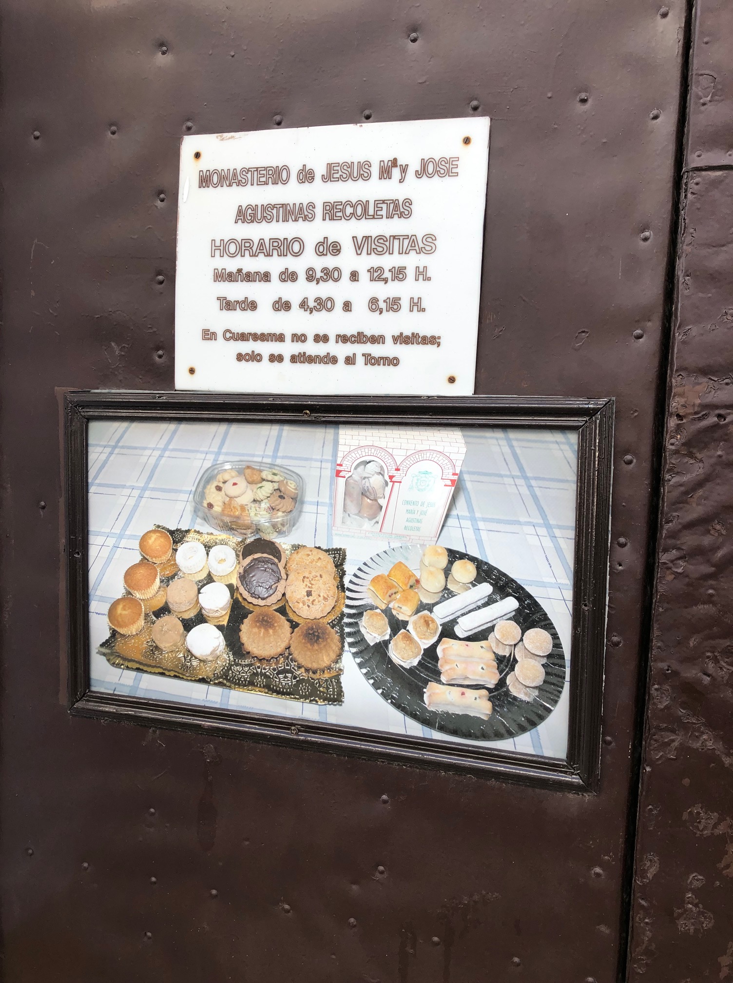
Next to the church, we were delighted to find that the Monasterio De Jesús, María Y José has a dulce turno. This is a lazy-susan type cabinet that allows you to purchase cookies and pastries made by the sequestered nuns who follow the convent’s centuries old recipes. It’s an interesting experience, talking in our inadequate Spanish through the wall to the invisible nun on the other side. We now seek out this opportunity wherever possible. The convent’s church has a noteworthy octagonal floor plan with its ceiling decorated with mural paintings.
Alcalá de los Gazules, a half hour away, was our next destination. Along with Medina-Sidonia and several other pueblos blancos, it is on the Ruta del Toro. This route through the open ranges of Cadiz Province highlights the region’s equestrian traditions on large fincas that raise Spain’s famous fighting bulls for the ring, as well as for their beef. Along the roadside here the iconic Osbourne Bull billboards playfully promote their brandy.
Rounding a curve, the hillside before us glittered with impressionistic white dots, which were nearly blinding in the midday sun. As we approached, their definition improved and revealed the old Arab village. The ancient footprint of the town hasn’t changed in centuries. The village is composed of multiple levels of terraced dwellings built above each other, along staircases, winding narrow lanes and alleys that traced the natural topography of the hill to its apex.
One of the advantages of shoulder season travel is that it is much easier to find a parking space. The disadvantage, though, is that some sites of interest have off-season hours, which was what we encountered with the Iglesia Parroquial de San Jorge and the Castillo de Alcala de los Gazules.
Since the Romans first laid stones for a fortress, the town has had a castle at its summit. It was the Moors though who built a small but substantial fortification that used the sloping wall technique, copied from the Templars, to build the Homage Tower. This impressive tower is all that is left after Napoleon’s troops blew apart the rest of the castillo as they exited following a brutal occupation of the town in 1810.
After the Reconquista, the towns’ Moorish past was erased with the construction of the Iglesia Parroquial de San Jorge above the old mosque. Its ornate gothic façade, carved from soft stone, now shows centuries of erosion. Later with the building of the Santo Domingo monastery, in 1506, the town was decreed to be a religious learning center. Although the monastery served as a training center for priests, it was also used for centuries to hold prisoners of the Spanish Inquisition.
A few minutes outside of the village, before continuing onto Castellar de la Frontera, we stopped for a late lunch/early dinner at los Corzos. It’s a large facility with a restaurant, café, grill and charcuterie shop, all featuring typical Andalusian fare. Though it appears to be geared for tourist buses that ply the route between Malaga and Cadiz, they take their cuisine very seriously and we had a splendid lunch.
The de la Frontera attached to many village names in Andalucia refers to a region officially called “Terra Nullius,” a ‘no man’s land.’ A fluctuating border area was established in the 1200s, when the first Reconquista, led by Ferdinand III of Castile-León, ran out of resources to continue their conquests farther. For two-hundred years this was an unclaimed land, in which Christian crusaders and Islamic jihadists continued to clash.
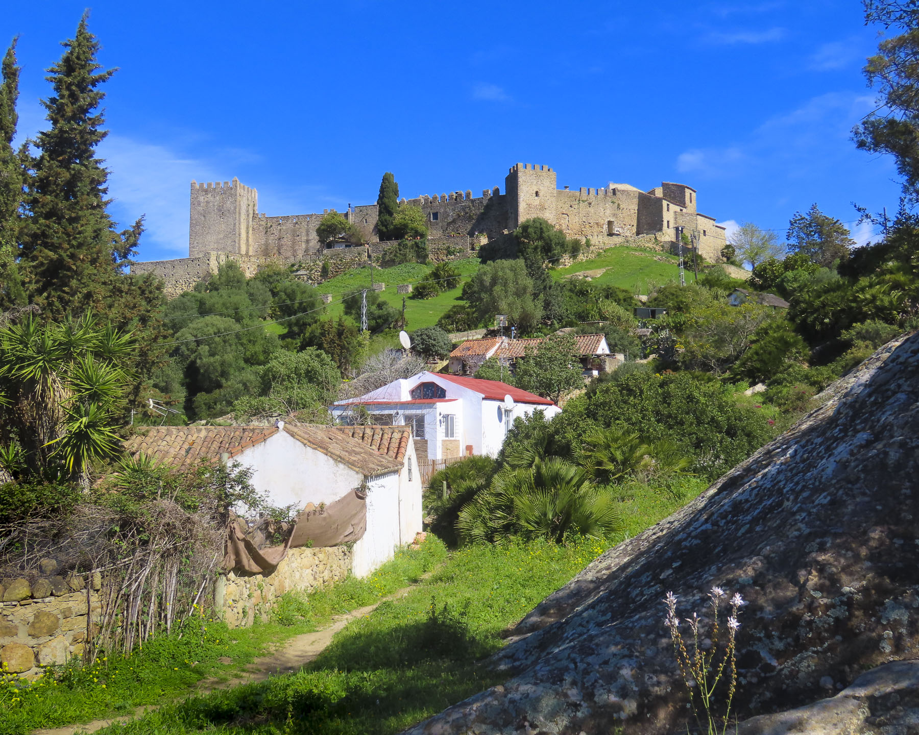
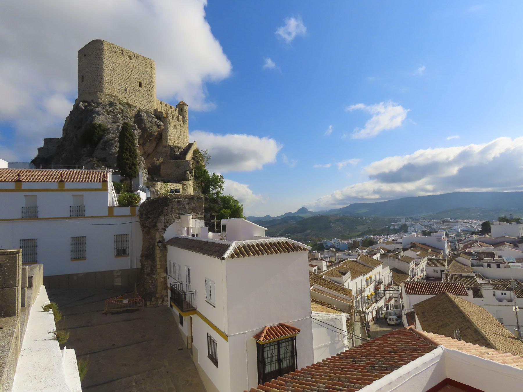
Castellar de la Frontera, still remotely isolated in the cork forests of Los Alcornocales Natural Park, truly exemplifies a wilderness fortress; with only one serpentine road in and out, it’s many miles off the main road. Today it is one of Europe’s best-preserved examples of a medieval village existing within a castle. But in the 1960’s it was a different story, when after centuries of neglect, and a dwindling population due to emigration, the remaining residents were relocated to a newly constructed town, Nuevo Castellar, ten miles away.
In the 1970s, northern European “hippies” discovered the fine Andalucian weather and the now abandoned village, squatting in some homes, and building rough shelters outside the castle walls. The old town was eventually obtained as an investment by the Rumasa Group, Spain’s largest conglomerate and the country’s leading hotel chain in the 1980’s. Later the company’s financial troubles led the Spanish Government to expropriate Castellar. They declared it a ‘Historical and Artistic Monument,’ and invested funding to restore the old castle and its village. Today rooms in the castle and several casas in the old village are reservable through Tugasa Castillo de Castellar Tugasa is a hotel organization formed by the Cadiz regional government and operates nine hotels and nine separate restaurants throughout the province.
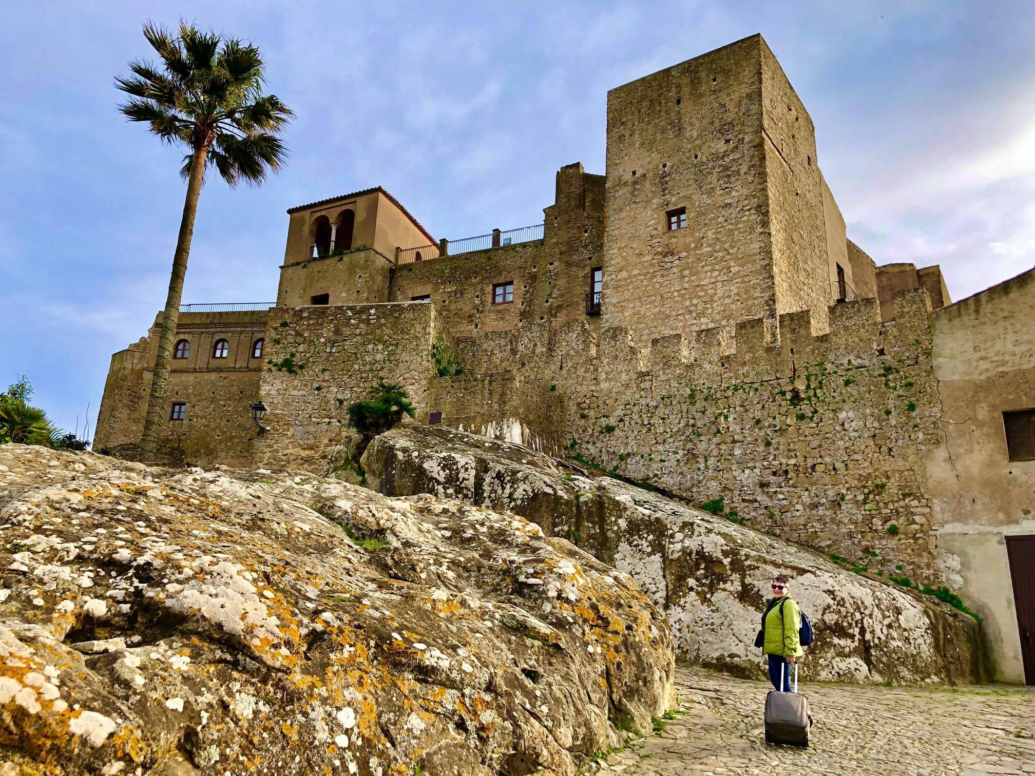
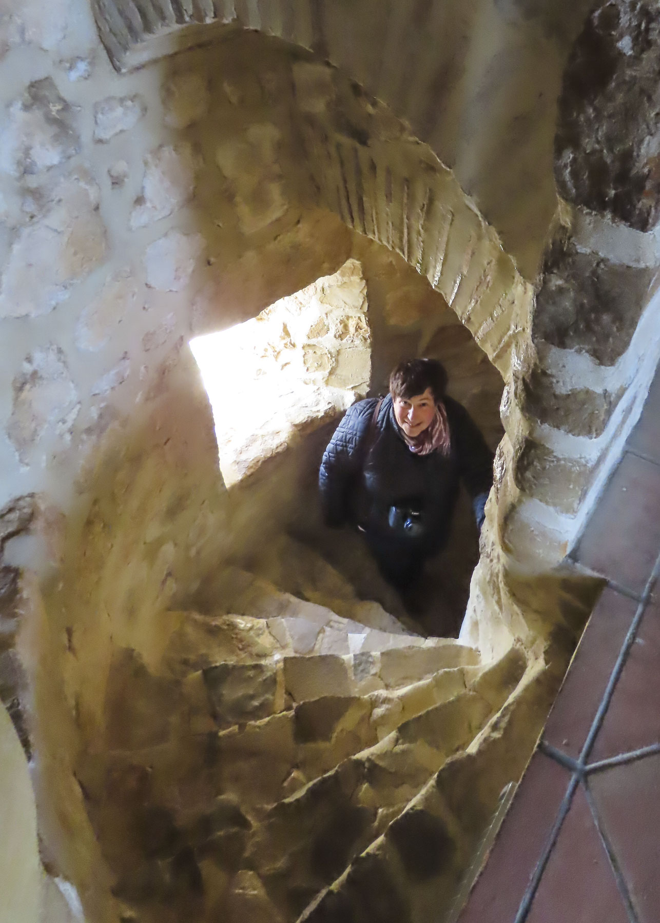
We didn’t realize our modestly priced (under €100) room would be ideally located in the Torre del Homenaje, the highest part of the castle with spectacular panoramic views. Getting to it was a bit of a challenge, even with the use of an elevator. The castle was built atop a huge multi-faceted rock protrusion, so that each ledge of the stone became one floor for rooms. While there are hallways from the elevator landings, they branch off and have short flights of stairs, up and down, to the rooms in various wings of castle. Signage was rather lacking, but after a few wrong turns we located No. 206.
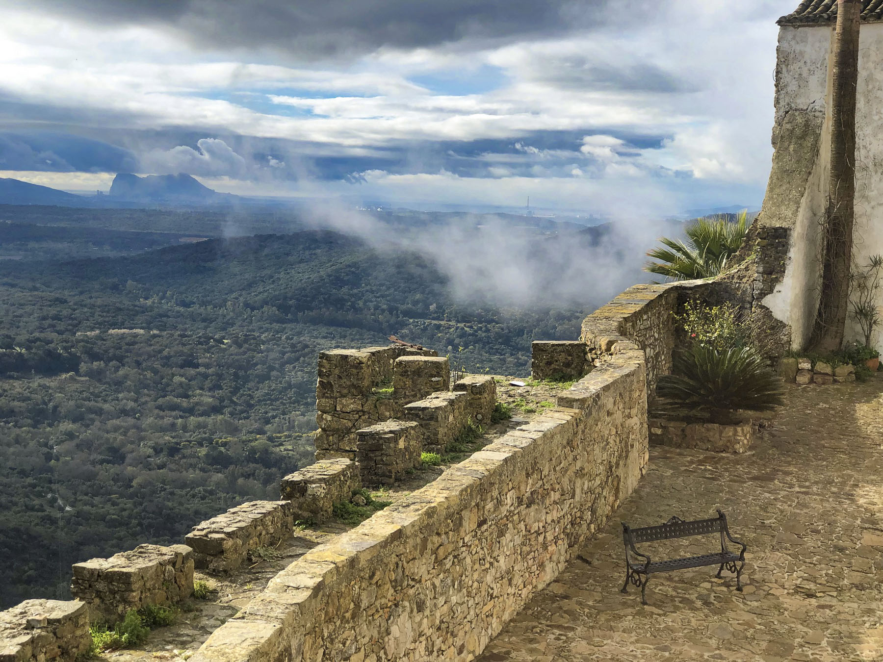
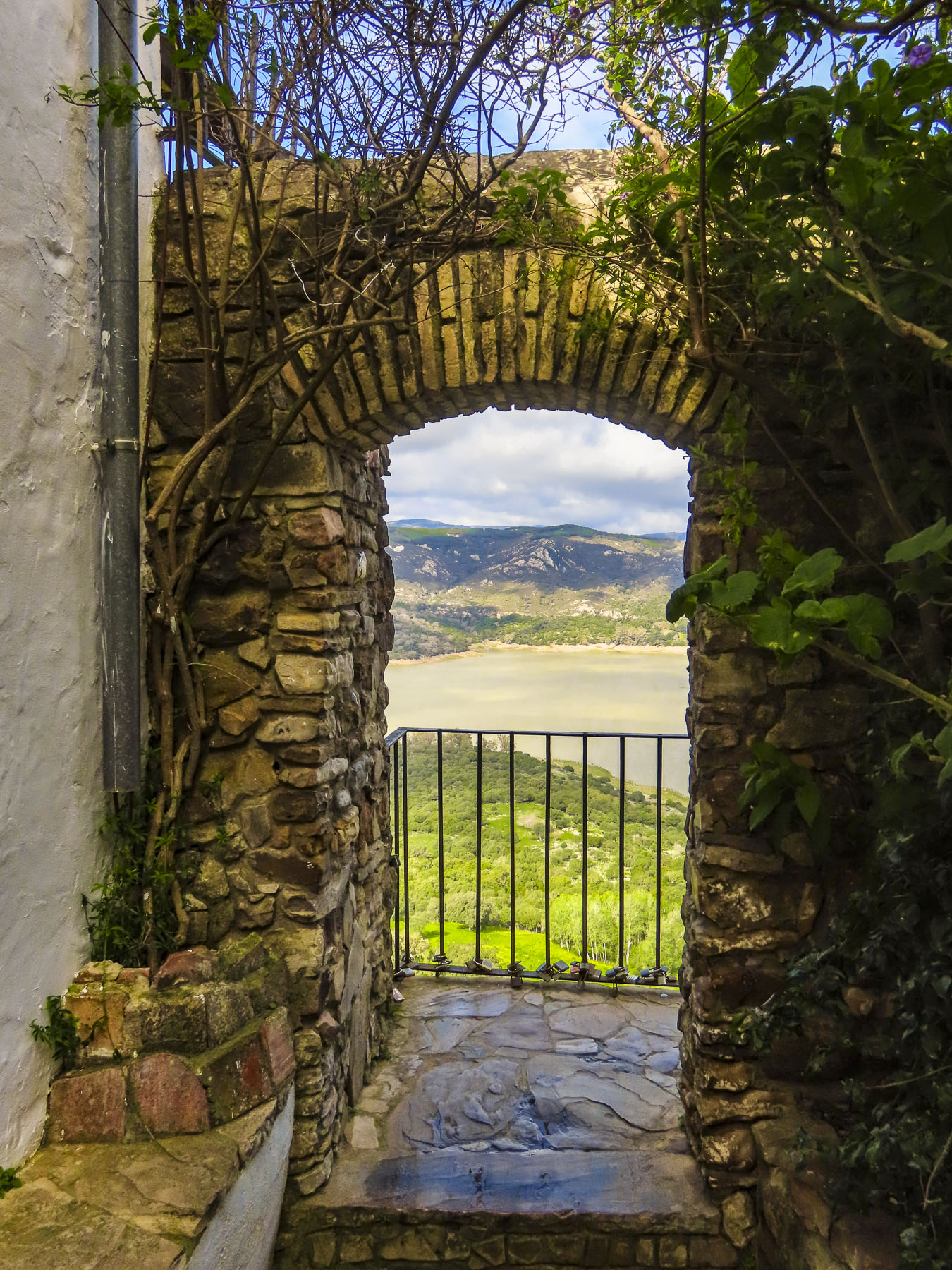
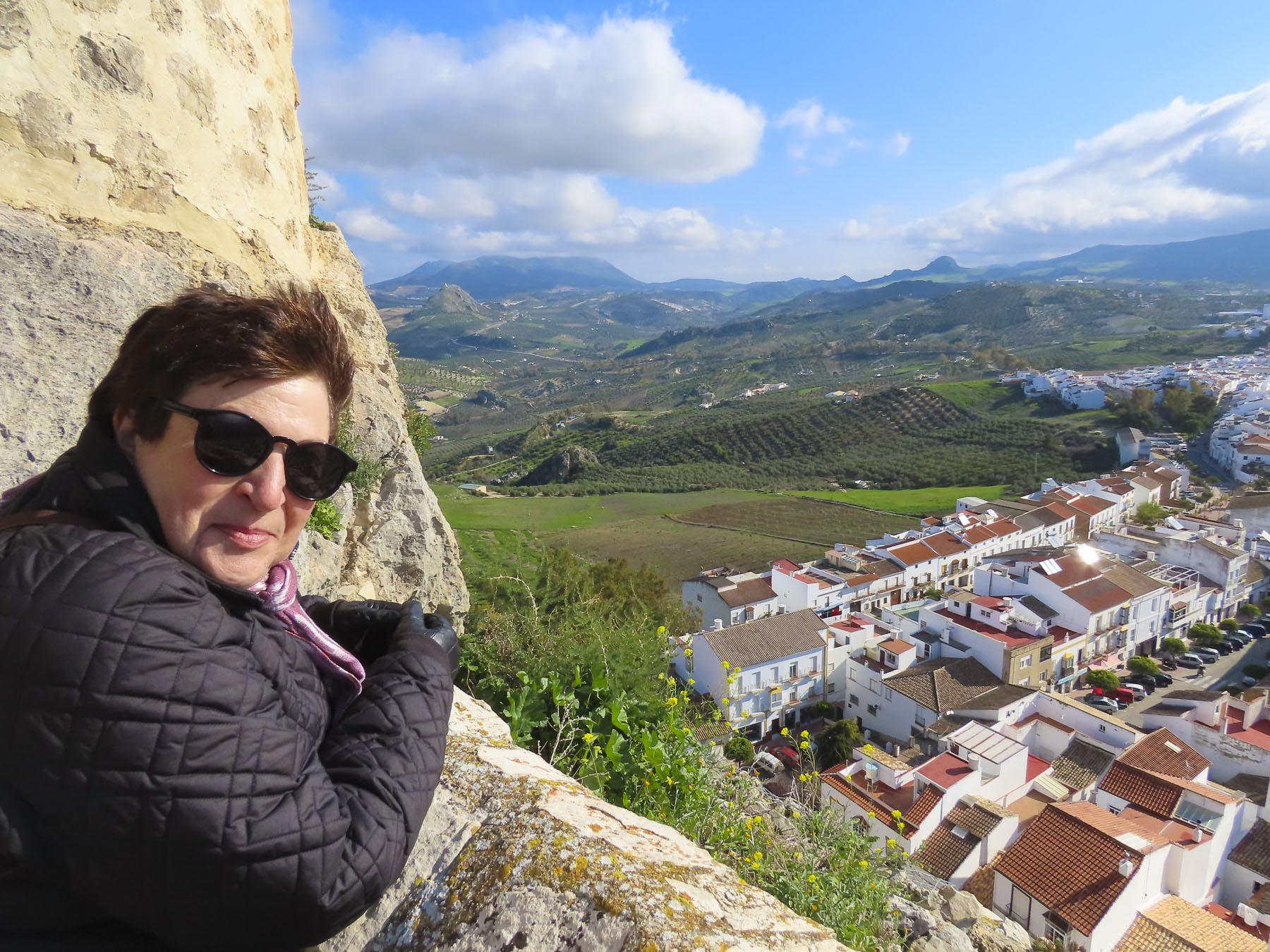
We were further surprised when we discovered that a narrow alcove in our room, with a twist and a turn, led to a sitting area with a small bedroom. Geez, if we had known we would have invited our kids. Better still, a set of stairs led to the top of the tower – our private mirador! To the manor born, for the next two days! We enjoyed incredible views: to the west over the Guadarranque reservoir, below the village, and southeast to the Rock of Gibraltar and the coast of Morocco beyond.
“Hey Rosa,” a lanky toothless patron smiled as he yelled, “tienes clientes,” you have customers, after we stood at the bar long enough to learn the gentleman was one of the original squatters of the 70’s. Two beers were all we could get from Rosa, as the kitchen was only open on weekends until the tourist season started later that Spring. Fortunately, we had purchased some bread, cheese, and sausage at los Corzos earlier, and we still had a vermut with us from Jerez de la Frontera, so we were set for a picnic dinner.
We rose for sunrise the next morning and watched kestrals zip along the castle’s walls. Over the reservoir a kettle of griffon vultures circled for a while before flying off. The medieval village within the castle’s wall is very compact and it was easy to wander through its attractive lanes. Outside the walls we spent a good bit of time walking about looking for the best vantage points to photograph this pretty village, which is recognized by Los Pueblos más Bonitos de Españaas being one of the nicest in Spain.
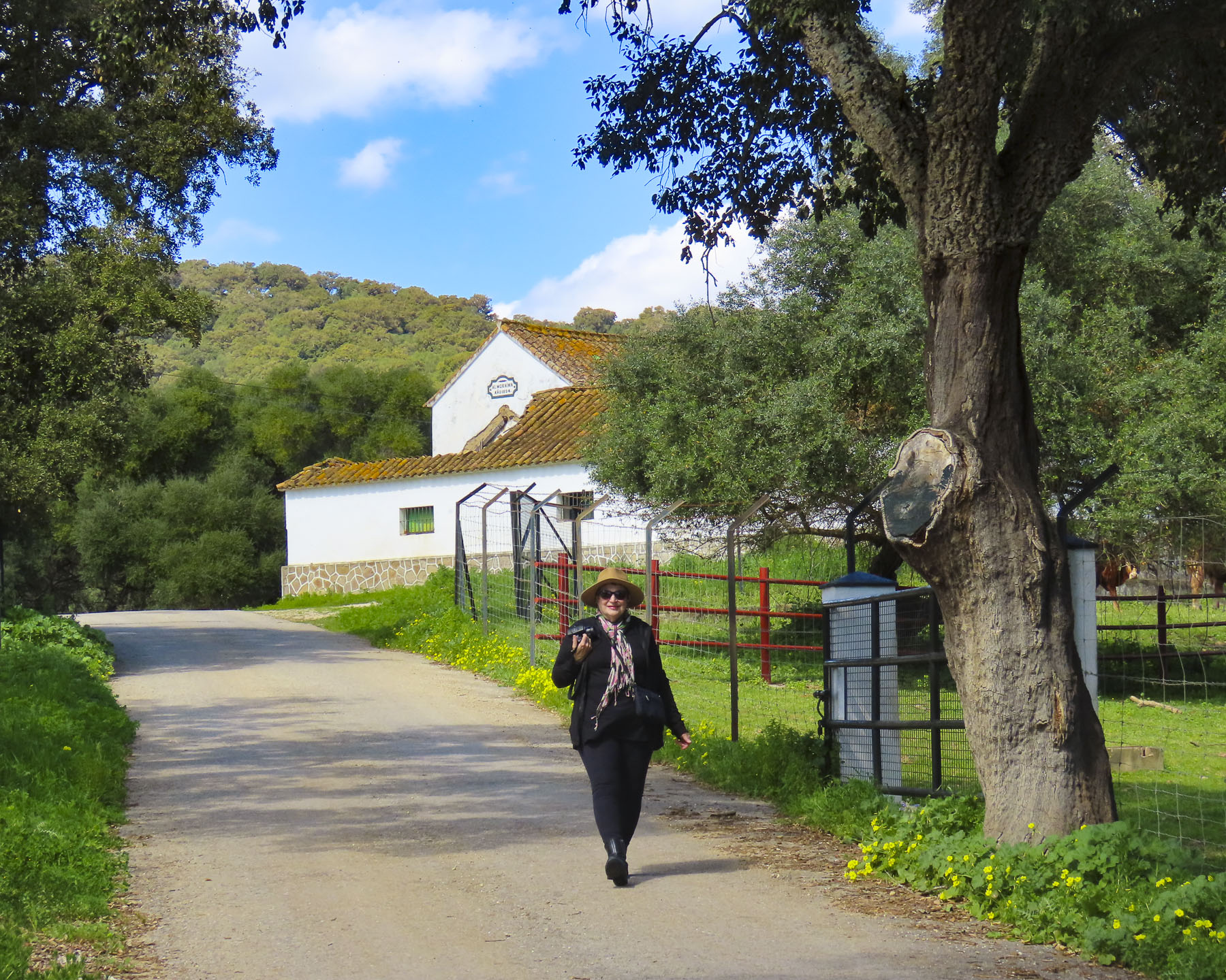
Later for coffee we stopped at the Hotel La Almoraima, located off the only road between the old town and Nuevo Castellar. The stunning hotel is set in what once was a 1600s convent and takes excellent advantage of the orange tree-filled courtyard and surrounding old cloisters, now renovated into chic rooms.
The convent’s original chapel has also been lovingly restored and is used regularly for weddings. The history of the architecturally distinctive tower that stands next to the cloister is vague, with some thinking it was an Arab watch tower, when this was the “Terra Nullius,” and existed before the religious complex was built. The old convent and its extensive lands, a vast 34,000-acre cork forest, eventually became the property of the Dukes of Medinaceli, who turned it into a palatial hunting estate, one of the largest in Spain.
By the 1890’s it was the destination for Spanish nobles and English aristocrats from Gibraltar, who participated in Royal Equestrian Hunts, and the Duke had a private station built on Henderson’s railway for their use. In 1922 Queen Victoria Eugenie of Spain exited at the Duke’s station and then traveled by horse drawn carriage to the estate and the ancient castillo for a brief visit. The eroded cart track to the castillo was finally improved and paved in 1924. In 1973 the 18th Duchess of Medinaceli sold the estate, which included the old hilltop castle, to the Rumasa Group. It was later seized by the Spanish government in the financially troubled 2010s and the Mexican actress Salma Hayek expressed interest in acquiring it before the government decided to manage the estate itself. I find these obscure histories fascinating!
Bar el Molino, a small taberna on the edge of Nuevo Castellar’s central plaza, was a wonderful untouristy spot. With shaded outside tables, cold beer and delicious food, our lunch was perfect. In an effort to experience as many different places as possible, we’ve started to take our after lunch or dinner coffee and dessert at a different establishment.
With this in mind we found Pasteleria Gastrokook, off by itself on the edge of town. Wow! We were so fortunate to stumble across this incredible pastry shop. This gourmet pastelería is reason enough to visit Castellar de la Frontera or even Spain. It is definitely worth a detour especially if you are near Gibraltar. We quickly conferred and declared a calorie-free day! I mean, what is the point of exploring all these distant locales without enjoying their cuisine. Geez, at our home in Georgia, USA, we can’t even find artisanal bread! I did gently chide the two cyclists that pedaled over from Gibraltar for ordering only black coffee. Surely, they would have burnt off all those calories by the time they returned to the rock. Sometimes, willpower is simply deprivation by choice.
For a moment I thought I was hallucinating, when the truck in front of us pulled away at the traffic circle and revealed a towering paranormal monster. A scene and song from GhostBusters! played through my mind. To say the least, this puffy creation was an odd introduction to a new destination, but Bibendum, or Bib, aka the “Michelin Man,” made us laugh.
After a long day of travel, our stomachs were now growling from hunger and Donna quickly located a small neighborhood restaurant, Rincón de Castro. It was only a few blocks away from Bib, down a side street, on the outskirts of Jerez de la Frontera. Shouldering our day packs, we entered the taverna and were obviously tourists – from the puzzled looks we received it was clear they didn’t get many foreign visitors through their doors. It turned out to be a delightful meal. We apologized for our minimal Spanish, and as the waitress seated us she asked Javier, who spoke very good English, to help us through the menu. He suggested the sherry, our first glasses in Spain, an appetizer, and a main. All the dishes were very good and we were enjoying the sherry. “And with your cafe, have you tried Tocino de Cielo? It’s a traditional Jerez dessert.” The name of the dessert roughly translates to ‘heaven’s bacon’, which reflects the dessert’s color only and is a total misnomer for this wonderful flan-like creation. The nuns of Convento del Espíritu Santo have been credited with the divine inspiration for this sweet treat, first baked 600 years ago. They created a recipe to use the huge quantity of leftover egg yolks donated to the convent from the sherry producers of Jerez, who only used the egg whites to clarify their wines. The oldest convent in the city, it dates from 1430, and still stands near the Cathedral of Jerez de la Frontera, between the Bodega Tio Pepe and Bodegas Fundador. Thus began our vacation. We were off to a good start.
We hadn’t heard any buzz about Jerez de la Frontera when we started planning our March Andalucia road-trip. This was a decision sparked by a great deal on airfare. Ultimately, we were headed to Cadiz, a destination highly recommended by our Italian friend Giulia several years ago. While planning the trip, we learned that Malaga, Seville, and Jerez de la Frontera all had good regional airports. We’d lived in Seville for a month several years ago and totally enjoyed immersing ourselves in the city’s life. But this would be a short two-week adventure and we didn’t want to repeat anything. Malaga, on the Mediterranean, seemed too far and we decided we would save that city for another time. And then there was Jerez de la Frontera, which looked surprisingly fascinating, when I started clicking around Google maps. We say surprisingly, because really it gets very little notice, even though it anchors the Sherry Triangle, an area that extends from Jerez northwest to Sanlúcar de Barrameda on the Atlantic coast, and south to El Puerto de Santa Maria, near Cadiz. It’s a quiet off-the-beaten-path destination, especially in the shoulder season. Larger than Cadiz, smaller than Seville, the city was the perfect size for a three-night, two-day stay, after arriving XRY. We don’t like to admit aging, but twenty hours of airports and flights takes a toll on us. So now that first afternoon after we land is spent recovering: airport, rental car, food, hotel in short order.
We emerged from the underground parking at the Plaza del Arenal, onto a large square centered with a bubbling equestrian statue, surrounded by empty tables. We would learn that come 8:00 every evening this would all change when folks filled the restaurants, tapas bars and side streets around the plaza with activity.
Following our host’s directions, we crossed the plaza and entered an arched alley that opened to the sky when it reached a small courtyard between the buildings. Shade netting strung across the alley created a picturesque play of light on the diners outside Bar Juanito.
The restaurant was just around the corner from our lodging at the Palacio del Virrey Laserna, a 13th century palace that has remained in the same family for several centuries. While the name is quite impressive, being a palace and all, and it does have some nice antiques along with some interesting décor in the guest wing, it feels a little tired. Perhaps this is an unfair criticism for an ancient family home. A tour of the private part of the palace was included in our room rate. Sadly, they restrict photos in this part of the palace, which is filled with fascinating ancient memorabilia and furniture collected from Spain’s various colonies at the apex of its empire. Interestingly, in 1264, it was one of forty Moorish properties given as a reward to the knights that valiantly served King Alfonso X during the Reconquista of Jerez. Located only a short distance from the Alcazar, the old Moorish fortress, its proximity and size indicated it was once the home of an important Moor.
As nice as the ambience was on the Plaza the del Arenal, prices were rather steep, so the next morning we walked down a side street off the square to Los Reyes Pastelería. One of everything would have been our first choice. Yum!
Later that morning we worked our way to the Mercado Central de Abastos, one of the oldest covered markets in Spain dating back to 1837. It has become part of our travel ritual to explore the central markets in the cities and towns we visit. The ones in Spanish cities close to the ocean are especially rewarding, as vendors display fresh seafood, shellfish, prawns and sea urchins. The Andalucia bounty doesn’t stop there. Olives, sausages, cheeses, and vegetables galore. And of course, jamon! The finest being named Pata Negra, in reference to their black hoofs. This jamon comes mostly from three villages, Jabugo, Cortegana, and Cumbres Mayores in the Sierra de Arecena mountains, two hours north of Jerez. Here the free-range pigs are raised on an organic diet of only acorns which imparts a unique flavor to the jamon. We made some purchases for a snack later.
Around the corner from the market the iconic Fundador sign sits atop a historic building which is home to an equally famous 100-year-old bar named the Gallo Azul, or Blue Rooster. Known for its 6th floor semi-circular bar, interesting interior, and view of Jerez from its windows, it was unfortunately under renovation when we were in the city but is now open.
Walk a little then café was our philosophy as we wandered our way across Jerez towards Plaza de la Yerba and Plaza de la Asunción. There seems to be an infinite number of eateries across the city to the point that it feels like are more restaurants than retail shops. The dilemma is that they all look so inviting.
We were in Jerez several weeks before Easter and signs of Holy Week preparations were evident at the Plaza de la Asunción, where reviewing stands surrounded the plaza in front of the ancient City Hall and Real Iglesia De San Dionisio Areopagita. Built in 1575, during the reign of Felipe II, the façade of the old town hall is covered in ornate relief carvings depicting popular Renaissance motifs and is considered one of the finest examples of Andalusian Renaissance architecture. Though now, its weathered stonework is in need of some tender-loving care.
The church across the plaza stands in austere beauty by comparison, its simple 15th-century Gothic-Mudejar architecture the perfect backdrop for the monument to la Virgen de la Asunción, centered in the plaza before it. Interestingly, the monument was a relatively new addition to the plaza in 1952. It was created by the legendary religious sculptor Juan Luis Vassallo, from Cadiz, whose many monumental pieces can be seen atop buildings and in public spaces across Spain.
The church’s belltower was originally a civilian construction in 1447 to serve as a watchtower to spot attackers or fires. Several years later the town’s first public clock was installed on it. The inside of the church features an 18th-century baroque interior. In preparation for Semana Santa, the statue of the Virgin stood in one corner dressed in her ceremonial attire. Maybe it’s just me, but I think there was a Barbie as Scarlett O’Hara, from Gone with the Wind, theme happening?
A huge church needs a significant name to match it and the Cathedral of Jerez de la Frontera / Colegiata de Nuestro Señor San Salvador successfully fills this obligation. It’s a massive structure supported with flying buttresses that we were able to get an aerial view of from the belltower across the way. It’s thought the belltower was reconfigured around a minaret that was part of the Great Mosque of Jerez before the reconquest.
With a special tax on sherry wine approved by the crown, construction of the cathedral was started in 1695. The first worship service was held sixty years later, but it would take another twenty years before the church was completed.
Inside the church is very austere, but voluminous. The soaring ceilings of the cavernous space is supported by monumental Corinthian columns, the width and height of giant sequoia trees. The huge doors on the ends of the naves dwarfed us. It was an enormous engineering feat.
The sacristy was interesting with a display of the church’s treasure. The old-world craftsmanship in the archaic religious objects was amazing. An odd detail was two doorknobs sculpted as dog heads. We asked the attendants if they knew the story behind them, but no. They were a playful insight into the mind of God’s representative in Jerez. In one corner a small alcove revealed a nautilus staircase that spiraled aloft. Disappointingly, it was roped off and Donna was unwilling to create a diversion for me to explore further.
Walking by along the bodegas of Gonzalez Byass, famous for its sherry aging warehouses, we made our way through a lovely, shaded park to Taberna La Sureña, a small tavern across from the Alcazar. “No se permite hablar de política, religión o deportes,” roughly translated as no talk of politics, religion or sports allowed, was wisely written in chalk above the bar. It’s a small space with only three tables inside and three on the sidewalk. We snacked on two local cheeses with sausage, crunchily addictive picos (a mini dry bread stick,) and our first taste of vermut, or vermouth, that wasn’t part of a martini. It was a wonderful, flavorful revelation. Though sherry and vermouth are considered fortified wines because brandy is added after fermentation, vermut additionally gets infused with spices and aromatic herbs. Flavorful and complex, the local vermut became our wine of choice during our trip through Andalucia.
Across the way the Alcazar of Jerez beckoned for exploration. The history of all the towns in Andalucia is complex, with loosely associated tribes, Phoenicians, Romans, Vandals and Visgoths. It wasn’t until the Moorish rule of the region between the 8th and 13th centuries that Jerez underwent a period of great urban development. It was during this time that the city was ringed with a defensive wall and the Alcazar was expanded to become a fortified palace and city-within-a-city, with its own separate economy, supported by a granary, warehouses and olive presses. With the Christian Reconquista in 1264 the Alcazar became the seat of the first Christian mayors of the city and the palace was used by royal visitors. The addition de la frontera (“of the frontier”) to cities’ name reflects that this was a hotly contested region, with an expanding and contracting border for many decades.
The discovery of the Americas in 1492 brought prosperity with the export of wine to Spain’s colonies in the New World. Interestingly a conquistador from Jerez, lvar Núñez Cabeza de Vaca, survived an ill-fated expedition which explored from the gulf coast of Florida to Texas. Surviving capture and enslavement by Indians, he and three compatriots trekked across the wilderness for eight years before being reunited with fellow Spaniards along the Gulf of Baja on the Pacific coast of Mexico. In his book La relacion y comentarios del gouernador Aluar Nuñez Cabeca de Vaca, the documenting of the native American tribes he encountered is so unique that he is regarded as the first ethnologist of the American southwest.
The ancient olive oil press at the Alcazar is huge. Touring the supporting production rooms with smaller presses and underground ceramic storage vats reinforced the importance of olive oil to the local economy centuries ago. A path through the gardens led to the old hammam. Centuries ago, it must have been quite an impressive structure with cool and hot baths, surely a luxury back then. The scale of the hammam is best seen from atop the fortress walls, some of which were constructed using a rammed earth technique.
We found the palace, renovated to a utilitarian boredom, the least interesting part of the grounds. Though it did have an intriguing set of wood doors carved with the profiles of famous citizens. And on the highest level there is a nice view of the Cathedral of Jerez across the park.
Later that evening as we strolled across town in search of elusive Alcauciles Fritos (Fried Baby Artichokes) we happened upon one of the cities’ brotherhoods practicing marching with a weighted platform before the big events of Holy Week. With military precision they followed their captain’s instructions and performed a switchback maneuver through restaurant tables that nearly blocked their route.
Down a side street near the central market, we found Tabanco La Reja, a small tapas bar far removed from the center of the city, that’s known for its local fare. The young seasonal artichokes are sprinkled with lemon juice and sea salt, then pan fried in oil over high heat until the stalks and hearts are tender, and the juices caramelized to set the flavor. They were sublime. Flamenco music from a tabanco across the calle drifted in, the vermut was good, the evening was perfect.
Strolling back to our hotel, concert music filled the street as we passed the Iglesia Conventual de San Francisco, drawing us inside. A Brotherhood band was playing to a full church. Another pre Semena Santa event that charmed us.
Churches, churches, churches. Spain, Italy, Portugal. Everywhere a church They share that history of religious influence that so dominated the emergence of European kingdoms during the Middle Ages and Renaissance. Princes and paupers donated for that access to the stairway to heaven, enriching the church with grand architecture, priceless art, and jeweled encrusted religious iconography. Which is exactly why we visit so many of them. “Follow the money, it’s where the art is,” is how I like to phrase it.
Covered in highly detailed baroque relief carvings, the Iglesia de San Miguel stood magnificently before us. Though much smaller than the Jerez Cathedral, the façade of this church and belltower are stunningly beautiful.
And the inside feels more intimate with a modest gilded altar. But we could only speculate on the hell fire and brimstone sermons that might have been delivered here based on a fiery retablo which dominates the church. Created by master sculptors Martínez Montañés and José de Arce, in the 17th Century, it depicts the Archangel Michael fighting very realistic devils.
Across from the church the sequestered nuns of the Convento San José Franciscanas Descalzas still operate a dulces turno, a lazy susan type cabinet, in the wall of the convent from which they sell pastries and cookies made from ancient church recipes to support themselves. It’s handy to have paper and pen to write down what you want from a list that hangs on the wall, or to use the translator app on your phone. It’s a wonderful centuries-old tradition that continues in many convents across Spain.
Scattered across Jerez are colorful ceramic advertising murals that usually highlight various sherries. They are all very artistic and seem to be unique to Jerez.
Touring a sherry bodega, a wine cellar, is a must in Jerez and there are several vintners in the city that offer tours, then tastings at their facilities. We chose Bodega Tio Pepe at Gonzalez Byass, basically for its convenience to other historic sites nearby. And we do admire their iconic Tio Pepe logo and advertising.
The bodega was started in 1835 by a young 23-year-old businessman, Manuel María González Ángel, who had no experience creating wine, but he enlisted the help of his beloved Uncle Pepe to show him the ropes. Their first sherry was well received, especially in England. In appreciation for his uncle’s expertise González named their sherry Tio Pepe, “Uncle Pepe.” The iconic logo was created in 1935 , and shows a bottle dressed with a wide-brimmed hat, Andalusian jacket, and Spanish guitar to celebrate the company’s 100th anniversary. It soon became one of the world’s most recognizable advertising logos. The sherry is exported to 115 countries around the world.
The tour through the old bodegas was very interesting, as the guide explained that tiered casks never get completely emptied. The ready-to-drink aged sherry is siphoned from the bottom barrel until it is one-third-full. It is then refilled with less aged sherry from the cask above. The procedure is repeated until new wine is added to the partially emptied top cask. From start to finish the aging of sherry takes four years. In keeping with the times, the tour ended in a very hip tasting area that features various configurations of the Tio Pepe logo.
Most worthy restaurants in Jerez don’t open until 8:00PM and then seem to instantly fill up, with patrons spilling onto the street. If you have a particular spot in mind, our suggestion is to arrive when it first opens, as many do not take reservations, or try dining there for lunch. The good news is Jerez takes its cuisine very seriously and there are few places geared toward tourists. The most popular street we found was Calle San Pablo, a narrow alley filled with lively tapas bars. It’s located between the Iglesia de San Miguel and Plaza del Arenal. A walk along Calle Consistorio which starts at the plaza will also lead you past many places that will whet your appetite.
Jerez de la Frontera has a wonderful tranquil ambience. Historic with a cosmopolitan flare, the city is often overlooked by folks visiting Andalucia. This is a blessing for those that enjoy its charms.
“If God had not made Jerez, how imperfect would his work be!” – Benito Perez Galdos.
The countryside on the way to Olvera was more verdant than the earth toned landscape we traversed on our way to Zahara de la Sierra at the beginning of our road trip. Now the hillsides were a mosaic of greens, light and soft, dark and vibrant, signaling the arrival of spring.
As the road curved, Olvera’s Castle and the belltowers of the town’s church broke the horizon. We are never quite sure where to park in small villages. Worried about getting fined for a parking violation, we always opt to play it safe and find a car lot. But the parking in Olvera was at the bottom of a steep incline below the historic castle and we just didn’t have the oomph that morning to walk from there uphill and then continue higher to the top of the tower. With some persistence we navigated the town’s labyrinth of narrow one-way lanes into the Plaza de la Iglesia. At the apex of the village, the plaza straddles the area between Olvera’s citadel and the town’s majestic church, Our Lady of the Incarnation Parish. Since it was still the off-season, we were in luck and found the last, barely viable parking spot on the plaza. It was a narrow space that required the driver’s side door to be parked tightly against a wall. Fortunately, I’m still limber enough to climb over the car’s center console and stick shift, with a limited amount of grunting and moaning.
The view from the mirador at the edge of the plaza was wonderful. Incredibly, the views across the village continued to get better and better as we climbed the different levels to the top of the Castillo de Olvera, perched atop a rocky outcrop at an altitude of 2000 feet. The climax was a spectacular view of the cathedral and panorama of whitewashed homes with red tiled roofs backed by a shimmering sea of silver green foiliage. Outside the village, the surrounding olive groves harbor nearly two million trees.
Constructed in the 12th century, the castle was part of a line of signal towers along the Moorish frontier in southern Spain. The castle was expanded in the 14th century when it was captured by King Alfonso XI during the Reconquista. The castilo is one of five in proximity to each other on The Castles Route, Witnesses of the Spanish Reconquest through the Moorish Strip, a no-man’s land that separated the ancient Christian Andalusia frontier from the Arab Kingdom of Granada. The other castles on the circuit are Castillo de las Aguzaderas, Castillo de Cote, Castillo de Morón de la Frontera, and the Castillo del Hierro.
With its size and architectural presence, Our Lady of the Incarnation Parish looks more like a cathedral than just a church. The neoclassical church was started in 1823 on the foundation of an earlier dismantled, gothic- mudéjar style church and dramatically counterbalances the castle on ridge above the village. Ordered built by The Dukes of Osuna, the feudal lords over Olvera, the vaulted interior is lined with marble imported from Italy and has many interesting religious icons. To fulfill this extravagance the Dukes diverted the town’s taxes, away from improving the village, to pay for it. They were the last feudal lords over Olvera and declared bankruptcy in 1843 when the church was completed. Then fled, never to be seen again.
A cloudless morning in Olvera turned overcast by the time we arrived in Setenil de las Bodegas only thirty minutes later. While considered a pueblo blanco, it’s totally different from Olvera and Zahara de la Sierra where the homes ascend the steep slopes under their town’s hilltop fortress. In Setenil de las Bodegas, whitewashed homes front caves under large stone overhangs which line both sides of a gorge, created eons ago from the erosion caused by the swift moving water.
The homes along the gorge use the mammoth natural stone ledge as their roofs. The once raging Rio Trejo is now a quiet stream in the narrow gorge, which widens into a shallow ravine where an ancient Moorish castle still guards the approach to the village. When the Romans colonized the area two thousand years ago folks had already been dwelling in the natural caves along the gorge for several millennia. Over the centuries the cave fronts were enclosed to create the unique village that still survives.
Before touring the village, we checked into the Hotel El Almendra to drop our bags, just oustside the historic district, with the intent of driving back and finding parking closer to the gorge. We were just about to pull out of the hotel parking lot when a group of police cars with lights flashing and sirens wailing roared past. A slower patrol car parked and blocked the hotel driveway. Folks were beginning to gather on the sidewalk. We had no idea why until a motorcycle carrying a cameraman facing backward led the first wave of bicycle racers that were a blur of pedaling color as they sped by. A continual surge of racers crested the knoll of the road and coursed downhill towards the village. The race was one leg of the annual Vuelta a Andalucia – Ruta del Sol. A five-day, 500 mile cross-country cycling event that summits 17 mountain passes in the region and attracts 600 riders. Leaving the car at the hotel, we decided to walk the half mile into the village.
By the time we reached Cuevas del Sol, Caves of the Sun, the narrow one-way road through the gorge lined with small taverns and inns, the sun was brightly shining again. Even though the road is open to cars, it was filled with folks walking and was almost pinched closed by tables from the restaurants narrowing its width. We found a table and enjoyed both the lunch and the warmth of the February sun.
Afterwards we walked the length of the lane through the deep chasm until a set of stairs led to the Mirador del Carmen and the small 18th century chapel Ermita de Ntra. Sra. Del Carmen. The view from the overlook encompassed a sweeping vista of the valley filled with whitewashed pueblos stacked atop one another filling the valley to its rim.
The Nazari Castle, the town’s 12th century Moorish fortress, still stands vigilantly on the edge of the valley, the invaders now camera-wielding tourists. Across from it the Gothic style Church of Our Lady of the Incarnation, itself an imposing fortress-like structure, was ordered built by the Spanish Crown. It was constructed in 1505, above the town’s previous mosque, to celebrate the liberation of the village from centuries of Arab rule. We walked back to our hotel along a lane above the gorge lined with newer buildings.
Heading back to Seville before sunrise the next morning we stopped high above the village on the road that followed the ridge opposite the Cuevas del Sol, in one last attempt to capture the iconic pueblos of the village as dawn cast its first rays of light across the gorge.
Till next time, Craig & Donna
PS. Our 226-mile weekend roundtrip from Seville only used slightly more than a half tank of gasoline.